

California map
San Francisco-Oakland-Fremont Metro Area map
The sheet's index lists 22 highways; I-580, US 101 and I-680 cross the most grid squares. Things to do inside the boundary: Alcatraz Island, Big Bus Tours San Francisco and Blue & Gold Fleet. Also on it: Antioch, Bay Point and Berkeley.
Open the map (PDF, US Letter)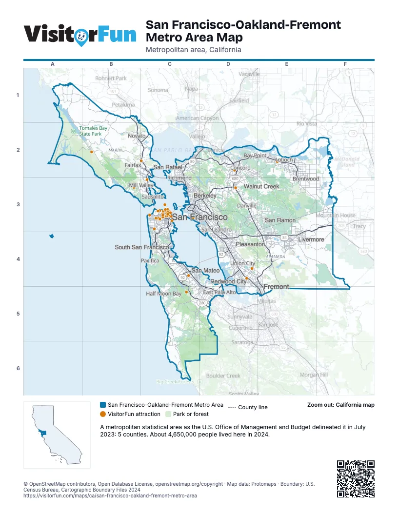
Highway index of San Francisco-Oakland-Fremont Metro Area
Each highway on the sheet and the grid squares it crosses.
- I-80C2, C3, D2
- I-205F3
- I-238D4
- I-280C3, C4, C5, D5
- I-380C4
- I-580C2, C3, D3, D4, E3, E4, F3
- I-680D2, D3, D4, E3, E4, E5
- I-880C3, D3, D4, E5
- I-980C3
- US 101B1, B2, C2, C3, C4, D4, D5
- CA 1C3, C4, C5, C6
- CA 4C2, D2, E2, E3, F3
- CA 13D3
- CA 24C3, D3
- CA 35C4
- CA 37C2
- CA 77D3
- CA 84D4, D5, E4
- CA 92C4, D4
- CA 160E2
- CA 242D2
- CA 262E4, E5
Things to do on the San Francisco-Oakland-Fremont Metro Area map
- Alcatraz Island
- Big Bus Tours San Francisco
- Blue & Gold Fleet
- California Academy of Sciences
- Chinatown
- Coit Tower
- Ghirardelli Square
- Golden Gate Park
- Grace Cathedral
- Gray Line San Francisco
- Haight-Ashbury
- Lombard Street
- Muir Woods National Monument
- Oracle Park
- Painted Ladies
- Palace of Fine Arts
- Point Reyes National Seashore
- Red and White Fleet
- San Francisco Cable Cars
- San Francisco Deluxe Tours
- San Francisco Museum of Modern Art
- San Francisco Zoo & Gardens
- The Fillmore
- Union Square
- American Bookbinders Museum
- Asian Art Museum
- Bike & View
- Blazing Saddles Bike Rentals and Tours
- Broadway Plaza
- City Cruises San Francisco
- Dandelion Chocolate
- de Young Museum
- Downtown Berkeley
- Filoli
- Hillsdale Shopping Center
- International Spy Shop
- Legion of Honor
- Local Tastes of the City Tours
- NewPark Mall
- Pacific Pinball Museum
- Ride California
- Ripley's Believe It or Not! San Francisco
- San Francisco City Guides
- San Francisco Historical Society
- San Francisco Railway Museum
- San Francisco Whale Tours
- Somersville Towne Center
- Stonestown Galleria
- Stretchy Pants Food Tours
- Sunvalley Mall
- The Mall at Northgate
- The Village at Corte Madera
- The Walt Disney Family Museum
- Tri-Valley
- Truhlsen-Marmor Museum of the Eye
Places on the map
- Antioch
- Bay Point
- Berkeley
- Brentwood
- Concord
- Danville
- East Palo Alto
- Fairfax
- Fremont
- Half Moon Bay
- Livermore
- Mill Valley
- Novato
- Pacifica
- Pleasanton
- Redwood City
- Richmond
- San Francisco
- San Leandro
- San Mateo
- San Rafael
- San Ramon
- Sausalito
- South San Francisco
- Union City
- Walnut Creek
© OpenStreetMap contributors, Open Database License, openstreetmap.org/copyright · Map data: Protomaps · Boundary: U.S. Census Bureau, Cartographic Boundary Files 2024















