

Colorado map
Denver map
About 729,019 people live here (Census Bureau, 2024 estimate). The sheet's index lists 205 streets; South Valley Highway, Peña Boulevard and Tuskegee Airmen Memorial Highway cross the most grid squares. Things to do inside the boundary: 16th Street, Ball Arena and Colorado State Capitol.
Open the map (PDF, US Letter)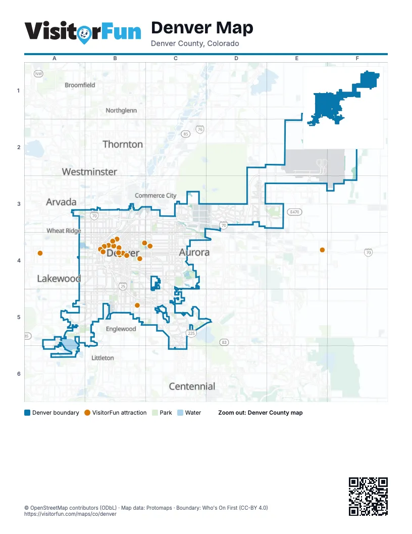
Street index of Denver
Each street on the sheet and the grid squares it crosses.
- North Tower RoadD2, D3
- Peña BoulevardD2, E2, D3
- E-470E2, E3
- North Jackson Gap StreetE2, E3
- Return to TerminalsE2
- Terminal EastE2, F2
- Terminal East Arrivals / Valet Parking / Short Term ParkingE2
- Terminal East DeparturesE2
- Terminal East ExitE2
- Terminal WestE2
- Terminal West Arrivals / Valet Parking / Short Term ParkingE2
- Terminal West DeparturesE2
- Terminal West ExitE2
- Heartland ExpresswayA3
- Sheridan BoulevardA3, A4
- West 48th AvenueA3
- West 52nd AvenueA3
- 38th StreetB3
- East 46th North AvenueB3, C3
- East 46th South AvenueB3, C3
- Federal BoulevardB3, B4
- Fox StreetB3
- Grand Army of the Republic HighwayB3
- Irving StreetB3, B4
- Lowell BoulevardB3, B4
- North Brighton BoulevardB3, B4
- North Downing StreetB3, B4
- North Josephine StreetB3, B4
- North Pecos StreetB3
- North Valley HighwayB3, B4
- North Vasquez BoulevardB3, C3
- North Washington StreetB3
- North York StreetB3, B4
- Park Avenue WestB3, B4
- Pecos StreetB3
- Tuskegee Airmen Memorial HighwayB3, C3, D3
- Walnut StreetB3, B4
- Washington StreetB3
- West 38th AvenueB3
- Zuni StreetB3, B4
- Dwight D. Eisenhower HighwayC3
- East 44th AvenueC3
- East 45th AvenueC3
- East 45th North DriveC3
- East 45th South DriveC3
- East 47th AvenueC3, D3
- East 56th AvenueC3, D3, E3
- East Northfield BoulevardC3
- Express Lane EntranceC3, D3
- Express Lanes EntranceC3
- Express Lanes ExitC3
- North Central Park BoulevardC3, C4
- North Colorado BoulevardC3, C4
- North Havana StreetC3, C4
- North Monaco StreetC3
- North Monaco Street ParkwayC3, C4
- North Northfield Quebec StreetC3
- North Quebec StreetC3, C4
- Sand Creek Drive SouthC3
- East 40th AvenueD3
- East 64th AvenueD3
- East Albrook DriveD3
- East Green Valley Ranch BoulevardD3, E3
- Express Lane ExitD3
- North Chambers RoadD3
- North Peoria CrossingD3
- North Peoria StreetD3
- Tower RoadD3
- East 38th AvenueE3
- East 48th AvenueE3
- North Picadilly RoadE3
- Morrison RoadA4, B4
- South Sheridan BoulevardA4, A5
- West 6th Avenue FreewayA4, B4
- West Alameda AvenueA4, B4
- 14th StreetB4
- 15th StreetB4
- 17th StreetB4
- 18th StreetB4
- 19th StreetB4
- 20th StreetB4
- 7th StreetB4
- Auraria ParkwayB4
- Blake StreetB4
- Champa StreetB4
- Cheyenne PlaceB4
- Chopper CircleB4
- East 13th AvenueB4, C4
- East 14th AvenueB4, C4
- East 17th AvenueB4, C4
- East 18th AvenueB4
- East 1st AvenueB4, C4
- East 22nd StreetB4
- East 31st AvenueB4
- East 6th AvenueB4, C4
- East 8th AvenueB4, C4
- East Alameda AvenueB4, C4
- East Buchtel North BoulevardB4, B5
- East Cherry Creek North DriveB4, C4
- East Cherry Creek South DriveB4, C4, C5
- East Colfax AvenueB4, C4
- East Martin Luther King Junior BoulevardB4, C4, D4
- East Mississippi AvenueB4, B5, C5
- East Ohio AvenueB4
- East Speer BoulevardB4
- East Walsh PlaceB4
- Galapago StreetB4
- Grant StreetB4
- Logan StreetB4
- Market StreetB4
- North BroadwayB4
- North Corona StreetB4
- North Downing Street ParkwayB4
- North Federal BoulevardB4
- North Kalamath StreetB4
- North Lincoln StreetB4
- North Santa Fe DriveB4
- North Speer BoulevardB4
- North Steele StreetB4
- North University BoulevardB4
- North Wyandot StreetB4
- Ogden StreetB4
- Osage StreetB4
- Park AvenueB4
- South BroadwayB4, B5
- South Downing StreetB4, B5
- South Downing Street ParkwayB4
- South Federal BoulevardB4, B5
- South Kalamath StreetB4
- South Lincoln StreetB4
- South Logan StreetB4, B5
- South Platte River DriveB4, B5
- South Santa Fe DriveB4, B5
- South Steele StreetB4
- South University BoulevardB4, B5
- South Valley HighwayB4, B5, C5, C6
- Stout StreetB4
- Welton StreetB4
- West 13th AvenueB4
- West 14th AvenueB4
- West 14th Avenue ParkwayB4
- West 22nd StreetB4
- West 23rd AvenueB4
- West 26th AvenueB4
- West 29th AvenueB4
- West 6th AvenueB4
- West 8th AvenueB4
- West 8th Avenue ViaductB4
- West Cedar AvenueB4
- West Colfax AvenueB4
- West Mississippi AvenueB4, B5
- West Mulberry PlaceB4
- Wewatta StreetB4
- East 17th Avenue ParkwayC4
- East 29th DriveC4
- East 6th Avenue ParkwayC4
- East Leetsdale DriveC4
- East Lowry BoulevardC4
- East Montview BoulevardC4
- East Virginia AvenueC4
- Montview BoulevardC4
- North Iola StreetC4
- North Uinta WayC4
- North Yosemite StreetC4
- South Colorado BoulevardC4, C5
- South Havana StreetC4, C5
- South Holly StreetC4, C5
- South Leetsdale DriveC4
- South Monaco ParkwayC4
- South Monaco Street ParkwayC4, C5
- South Parker RoadC4, C5, D5
- South Quebec StreetC4, C5, C6
- South Kipling StreetA5
- South Wadsworth BoulevardA5, A6
- West Evans AvenueA5, B5
- West Florida AvenueA5, B5
- West Hampden Avenue FreewayA5, B5
- West Jewell AvenueA5, B5
- West Quincy AvenueA5
- East Arkansas AvenueB5
- East Buchtel BoulevardB5, C5
- East Buchtel South BoulevardB5
- East Evans AvenueB5, C5
- East Yale AvenueB5, C5
- East Yale WayB5, C5
- South Platte River Drive WestB5
- West Dartmouth AvenueB5
- DTC BoulevardC5, C6
- East Dartmouth AvenueC5
- East Eastmoor DriveC5
- East Florida AvenueC5
- East Hampden AvenueC5
- East Iliff AvenueC5
- East Princeton AvenueC5
- East Quincy AvenueC5
- I-225 Frontage Road NorthC5
- I-225 Frontage Road SouthC5
- South Frontage RoadC5
- South Monaco StreetC5, C6
- South Syracuse WayC5
- South Tamarac DriveC5
- South Tamarac Street ParkwayC5
- South Yosemite StreetC5, C6
- West Belleview AvenueA6
- East Belleview AvenueC6
Things to do on the Denver map
- 16th Street
- Ball Arena
- Colorado State Capitol
- Coors Field
- Denver Art Museum
- Denver Botanic Gardens
- Denver Charter Fishing
- Denver Mint
- Denver Museum of Nature & Science
- Denver Zoo Conservation Alliance
- Elitch Gardens
- Empower Field at Mile High
- Larimer Square
- Meow Wolf Denver: Convergence Station
- Molly Brown House Museum
- Union Station Denver
Places on the map
- 16th Street Mall
- 39th Avenue Greenway
- Advenir at Cherry Creek North
- Advenir at French Quarter
- AdventHealth Porter Hospital
- Alamo/National
- Alta Springs Apartments
- Altaira at High Point
- Arapahoe Station
- Aria Denver
- Athmar Park
- Avion at Denver Connection
- Avion Townhomes
- Avis
- Baker
- Barnum
- Barnum Park South
- Barnum West
- Bear Creek Park and Trail
- Bear Creek Terrace
- Bear Valley Park
- Beaumont Place
- Beeler Park
- Belvedere
- Berkeley
- Berkeley Lake
- Berkeley Park
- Bible Park
- Bluff Lake Nature Center
- Broadway Marketplace
- Bungalows
- Burnham Rail Yard
- Canyon Club Condos
- Capitol Hill
- Carriage Park
- Carriage Place Apartment Homes
- Celebration
- Central Business District
- Central Park
- Chaffee Park
Next to Denver
- Arvada
- Aurora map
- Broomfield
- Centennial
- Commerce City
- Englewood
- Greenwood Village
- Lakewood
- Littleton
- Northglenn
- Thornton
- Westminster
- Wheat Ridge
© OpenStreetMap contributors (ODbL) · Map data: Protomaps · Boundary: Who's On First (CC-BY 4.0)