

New York map
Bronx County map
About 1,384,724 people live here (Census Bureau, 2024 estimate). The sheet's index lists 279 streets; Bruckner Boulevard, Bruckner Expressway and Major Deegan Expressway cross the most grid squares. Things to do inside the boundary: Bronx Music Hall, Bronx Zoo and New York Botanical Garden.
Open the map (PDF, US Letter)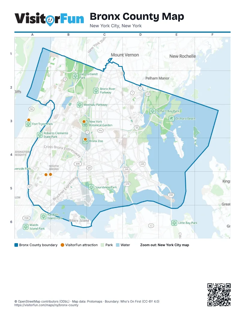
Street index of Bronx County
Each street on the sheet and the grid squares it crosses.
- BroadwayB1, B2
- Central Park AvenueB1
- David Sheridan PlazaB1
- Henry Hudson ParkwayB1, A2, B2
- Henry Hudson Parkway EastB1, A2, B2
- Henry Hudson Parkway WestB1, A2, B2
- Jerome AvenueB1, B2, B3, A4, B4
- Major Deegan ExpresswayB1, B2, A3, B3, A4, A5
- Mosholu AvenueB1
- Mosholu ParkwayB1, B2, B3
- New York State ThruwayB1
- Riverdale AvenueB1, B2
- South BroadwayB1
- West 254th StreetB1
- Baychester AvenueC1, C2, D2, D3
- Bronx River ParkwayC1, C2, C3, C4, C5
- East 241st StreetC1
- East 242nd StreetC1
- Murdock AvenueC1, C2
- Van Cortlandt Park EastC1, B2, C2
- West 3rd StreetC1
- White Plains RoadC1, C2, C3, C4, C5
- Mundy LaneD1, D2
- Independence AvenueA2
- Irwin AvenueA2, B2
- Johnson AvenueA2, B2
- Kappock StreetA2
- Bailey AvenueB2, B3
- Bainbridge AvenueB2, B3
- Delafield AvenueB2
- Dickinson AvenueB2
- East 233rd StreetB2, C2, D2
- East Gun Hill RoadB2, C2, C3, D3
- Grand ConcourseB2, B3, A4, B4, A5
- Grosvenor AvenueB2
- Manhattan College ParkwayB2
- Reservoir AvenueB2, B3
- Sedgwick AvenueB2, A3, B3, A4
- Van Cortlandt Avenue EastB2, B3
- Van Cortlandt Avenue WestB2
- Van Cortlandt Park SouthB2
- West 230th StreetB2, B3
- West 239th StreetB2
- West 242nd StreetB2
- West 253rd StreetB2
- West Gun Hill RoadB2
- West Mosholu Parkway SouthB2
- Barnes AvenueC2, C3
- Boston RoadC2, D2, C3, B4, B5
- Bronxwood AvenueC2, C3
- Bussing AvenueC2, D2
- East 222nd StreetC2, D2, D3
- East 229th StreetC2
- East 236th StreetC2
- Eastchester RoadC2, C3, C4
- Grace AvenueC2, D2, D3
- Laconia AvenueC2, C3
- Needham AvenueC2
- Nereid AvenueC2, D2
- Pitman AvenueC2
- Schieffelin AvenueC2
- Webster AvenueC2, B3, C3, A4, B4
- Bivona StreetD2
- Carver LoopD2
- Co-op City BoulevardD2, D3
- Conner StreetD2
- Dyre AvenueD2
- Givan AvenueD2
- Hollers AvenueD2
- Hutchinson AvenueD2
- Hutchinson River ParkwayD2, D3, D4, D5
- Light StreetD2
- New England ThruwayD2, E2, D3
- Peartree AvenueD2
- Pinkney AvenueD2
- Pratt AvenueD2
- Pratt StreetD2
- Provost AvenueD2
- Reeds Mill LaneD2
- Rombouts AvenueD2
- Ropes AvenueD2
- Secor AvenueD2
- Seton Avenue - Mundy LaneD2
- South 3rd AvenueD2
- Spring RoadD2
- Steenwick AvenueD2
- Tillotson AvenueD2
- Pelham Shore RoadE2
- Shore RoadE2, D3, E3
- University AvenueA3, B3, A4
- University Heights BridgeA3
- West 179th StreetA3
- West Burnside AvenueA3, B3
- West Fordham RoadA3, B3
- West Tremont AvenueA3, B3, A4
- Bedford Park BoulevardB3
- Bedford Park Boulevard WestB3
- Crotona AvenueB3, B4
- East 180th StreetB3, B4, C4
- East 187th StreetB3
- East 192nd StreetB3
- East 198th StreetB3
- East 204th StreetB3
- East Burnside AvenueB3, B4
- East Fordham RoadB3, C3
- East Kingsbridge RoadB3
- East Tremont AvenueB3, B4, C4, D4, D5
- Goulden AvenueB3
- Southern BoulevardB3, C3, B4, B5
- Third AvenueB3, B4, A5, B5
- Valentine AvenueB3, B4
- West 225th StreetB3
- West Kingsbridge RoadB3
- Allerton AvenueC3, D3
- Bronx Park EastC3
- Bronx River Parkway EntranceC3, C4
- Bronx River Parkway RoadC3
- Bronxdale AvenueC3, C4
- Burke AvenueC3
- EsplanadeC3
- Pelham ParkwayC3, D3
- Pelham Parkway NorthC3
- Pelham Parkway SouthC3, D3
- Williamsbridge RoadC3, C4
- Amendola PlaceD3
- Bartow AvenueD3
- Bartow Pell CircleD3
- Bay Plaza BoulevardD3
- Bay Plaza DriveD3
- Bruckner BoulevardD3, C4, D4, A5, B5, C5, A6
- Bruckner ExpresswayD3, C4, D4, A5, B5, C5, A6
- Charles J. Crimi RoadD3
- City Island RoadD3, E3
- DeReimer AvenueD3
- Edson AvenueD3
- Erskine PlaceD3
- Hammersley AvenueD3
- Hutchinson River Parkway EastD3
- Mall BoulevardD3
- Orchard Beach RoadD3, E3
- Palmer AvenueD3
- Stillwell AvenueD3
- Westchester AvenueD3, B4, C4, D4, A5, B5
- Wilkinson AvenueD3, D4
- City Island AvenueE3, E4
- City Island BridgeE3
- City Island CircleE3
- Park DriveE3
- Brook AvenueA4, A5
- Cross Bronx ExpresswayA4, B4, C4, D4, D5
- Depot PlaceA4
- East 161st StreetA4, A5
- East 165th StreetA4
- East 167th StreetA4, B4, B5
- East 170th StreetA4, B4
- Edward L. Grant HighwayA4
- Macombs Dam BridgeA4
- Macombs RoadA4
- Major Deegan Entrance NorthboundA4
- Melrose AvenueA4, A5
- Ogden AvenueA4
- River AvenueA4, A5
- Washington BridgeA4
- West 167th StreetA4
- West 170th StreetA4
- Arthur AvenueB4
- Boone AvenueB4
- Bronx River AvenueB4, C4, B5
- Claremont ParkwayB4
- Clay AvenueB4
- Cross Bronx Expressway Service RoadB4, C4, D4, D5
- Crotona Park NorthB4
- East 168th StreetB4
- East 169th StreetB4, B5
- East 172nd StreetB4, C4
- East 174th StreetB4, C4
- East 175th StreetB4
- East 177th StreetB4, C4
- Edgewater RoadB4, B5
- Franklin AvenueB4
- Louis Niñé BoulevardB4
- Prospect AvenueB4, B5
- Sheridan BoulevardB4, B5
- West Farms RoadB4, B5
- Whitlock AvenueB4, B5
- Wilkins AvenueB4
- Brush AvenueC4, D4, D5
- Castle Hill AvenueC4, C5
- Commerce AvenueC4, D4
- East Tremont Avenue / Westchester SquareC4
- Harrod AvenueC4
- Havemeyer AvenueC4
- Hugh J. Grant CircleC4
- Lane AvenueC4
- Metcalf AvenueC4, C5
- Metropolitan AvenueC4
- Metropolitan OvalC4
- Morris Park AvenueC4
- Rosedale AvenueC4, C5
- Silver StreetC4
- Unionport RoadC4
- Virginia AvenueC4
- Waters PlaceC4, D4
- Watson AvenueC4, B5, C5
- Zerega AvenueC4, C5
- Country Club RoadD4
- Crosby AvenueD4
- Dean AvenueD4
- Ellsworth AvenueD4, D5
- Hollywood AvenueD4
- Hutchinson River ExpresswayD4, D5
- Hutchinson River Parkway NorthD4
- Hutchinson River Parkway Service RoadD4, D5
- Jarvis AvenueD4
- Kearney AvenueD4
- Lafayette AvenueD4, B5, C5, D5
- Layton AvenueD4
- Logan AvenueD4
- MacDonough PlaceD4
- Middletown RoadD4
- Otis AvenueD4
- Randall AvenueD4, B5, C5, D5
- Saint Joseph's WayD4
- Stadium AvenueD4
- Throgs Neck ExpresswayD4, D5, E5
- Throgs Neck Expressway Service RoadD4, D5, E5
- 145th Street BridgeA5
- 3rd AvenueA5
- Bergen AvenueA5
- East 133rd StreetA5, A6
- East 134th StreetA5
- East 135th StreetA5
- East 138th StreetA5, B5, B6
- East 139th StreetA5
- East 147th StreetA5
- East 149th StreetA5, B5
- East 150th StreetA5
- East 163rd StreetA5, B5
- Elton AvenueA5, B5
- Exterior StreetA5
- Gerard AvenueA5
- Lincoln AvenueA5
- Madison Avenue BridgeA5
- Morris AvenueA5
- Saint Ann's AvenueA5
- Third Avenue BridgeA5
- Washington AvenueA5, B5
- Willis AvenueA5
- Willis Avenue BridgeA5
- Barry StreetB5
- Bryant AvenueB5
- East Bay AvenueB5
- Food Center DriveB5, C5
- Garrison AvenueB5
- Halleck StreetB5
- Hoe AvenueB5
- Hunts Point AvenueB5
- Leggett AvenueB5
- Longwood AvenueB5
- Oak Point AvenueB5
- Reverend James A. Polite AvenueB5
- Spofford AvenueB5
- Story AvenueB5, C5
- Tiffany StreetB5
- Viele AvenueB5
- Whittier StreetB5
- Barrett AvenueC5
- Lacombe AvenueC5
- Morrison AvenueC5
- Soundview AvenueC5
- Balcom AvenueD5
- Bronx-Whitestone BridgeD5
- Dewey AvenueD5
- Harding AvenueD5, E5
- Lawton AvenueD5
- Pennyfield AvenueD5, E5
- Schley AvenueD5
- Throgs Neck BridgeE5
- Robert F. Kennedy BridgeA6
Things to do on the Bronx County map
Places on the map
- 149th Street–Grand Concourse
- 153rd Street Garage
- 161st Street–Yankee Stadium
- 164th Street Garage
- 167th Street
- 174th-175th Streets
- 239th Street Yard
- Academy of Mount Saint Ursula
- Action Environmental Services
- Allerton Library
- Alumni Gymnasium
- Amalgamated Housing Cooperative
- Amazing Amphibians
- Aqueduct Walk
- Babe Ruth Plaza
- Bailey Playground
- Baldor Specialty Foods
- Ballfield 5
- Bally's Golf Links at Ferry Point
- Bay Plaza Shopping Center
- Baychester Houses
- Best Western Plus
- Bethany Lutheran Church
- Bill Rainey Park
- Block Group 2, Bronx, NY
- Borgia Butler Houses
- Boston Secor Houses
- Boulevard Post Office
- Bridge Park
- Bronx Borough Jail
- Bronx County
- Bronx High Point
- Bronx Library Center
- Bronx Park
- Bronx Point
- Bronx Psychiatric Center
- Bronx River Arts Center
- Bronx River Houses
- Bronx River Parkway
Next to Bronx County
- Harbor Hills
- Harlem
- Mount Vernon map
- New Rochelle map
- Pelham
- Pelham Manor
- Saddle Rock
- Washington Heights map
© OpenStreetMap contributors (ODbL) · Map data: Protomaps · Boundary: Who's On First (CC-BY 4.0)