

South Carolina map
Charleston map
About 157,665 people live here (Census Bureau, 2024 estimate). The sheet's index lists 300 streets; Mark Clark Expressway, Savannah Highway and Folly Road cross the most grid squares. Things to do inside the boundary: Angel Oak, Charles Towne Landing and Charleston City Market.
Open the map (PDF, US Letter)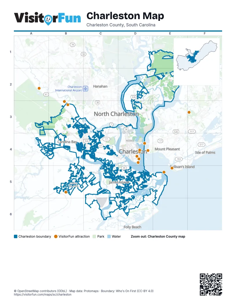
Street index of Charleston
Each street on the sheet and the grid squares it crosses.
- Mark Clark ExpresswayD2, C3, D3, E3, C4
- James Island ExpresswayD4, D5
- Arthur Ravenel Jr BridgeD4
- Septima Clark ExpresswayD4
- Clements Ferry Road SouthD2
- Clements Ferry Road NorthD2, D3
- Merritt RoadD4
- Savannah HighwayA4, B4, C4, D4
- Ashley River RoadB3, C3, C4
- Bees Ferry RoadB3, A4, B4
- King StreetD3, D4
- Meeting StreetD3, D4
- Folly RoadC4, C5, D5, D6
- Sam Rittenberg BoulevardC3, C4
- Saint Andrews BoulevardC4, D4
- Glenn McConnell ParkwayB3, B4
- Lockwood DriveD4
- Glen McConnell ParkwayB3, B4
- Paul Cantrell BoulevardB4, C4
- Calhoun StreetD4
- Old Towne RoadC4
- Septima P. Clark ParkwayD4
- Folly Road BoulevardC4, D4
- Cosgrove AvenueC3
- Spring StreetD4
- Cannon StreetD4
- Wesley DriveC4
- Clements Ferry RoadD2, E2, F2, D3
- Maybank HighwayB5, C5
- Riverland DriveC4, C5, D5
- Harbor View RoadC5, D5
- Daniel Island DriveD3
- Rutledge AvenueD4
- Fort Johnson RoadD5
- Hwy 41F1, F2
- Wappoo RoadC4
- Main RoadB4, B5
- Seven Farms DriveD3
- East Bay StreetD4
- Camp RoadC5, D5
- Morrison DriveD4
- River Landing DriveD3
- Fishburne StreetD4
- Orleans RoadC4
- Broad StreetD4
- Magwood DriveC3, B4, C4
- South Grimball RoadC5, D5, C6
- Country Club DriveC4, D4, C5
- West Oak Forest DriveC4
- Mount Pleasant StreetD4
- Playground RoadC4
- Tobias Gadson BoulevardC4
- Saint Thomas Island DriveD3
- Old Folly RoadC5
- Island Park DriveD2, E2, D3
- Cainhoy RoadE1, E2
- River RoadB4, B5, C5, C6
- Ashley AvenueD4
- Ashley Hall RoadC3, C4
- Secessionville RoadD5, D6
- Orange Grove RoadC3, C4
- Halfway Creek RoadF1
- Murray BoulevardD4
- Ashley Town Center DriveC4
- Henry Tecklenburg DriveB4, C4
- Dogwood RoadB3, C3, B4
- Savage RoadC4
- Coming StreetD4
- Fairchild StreetD3
- Dills Bluff RoadD5
- Huger StreetD4
- Central Park RoadC5
- George L Griffith BoulevardC5, D5
- Ashley Crossing DriveB3, C3, C4
- Smith StreetD4
- Tradd StreetD4
- President StreetD4
- Wappoo DriveC4, C5
- Albemarle RoadD4
- Moultrie StreetD4
- Church StreetD4
- Frontage RoadC4
- Beaufain StreetD4
- Queen StreetD4
- Concord StreetD4
- Hagood AvenueD4
- Battery Island DriveD6
- Raoul Wallenberg BoulevardC4
- West Wildcat BoulevardB4
- Austin AvenueD3
- Romney StreetD4
- Hagood StreetD3
- Bee StreetD4
- Columbus StreetD4
- Old Military RoadD6
- Reflectance RoadF1, F2
- Ellis Oak DriveD5
- Bohicket RoadB5
- Heriot StreetD4
- Grimball RoadD6
- Windermere BoulevardC4
- Courtenay DriveD4
- Essex Farms DriveB4
- Ripley Point DriveD4
- Ashley Point DriveD4
- Summerville AvenueD3
- Cumberland StreetD4
- South Market StreetD4
- North Market StreetD4
- Old Charleston RoadA4, B4
- Market StreetD4
- Doscher AvenueD3
- North Shore DriveD5
- Jonathan Lucas StreetD4
- Rutledge BoulevardD4
- Discher StreetD3
- Hughes RoadA4
- Skylark DriveC4
- Doughty StreetD4
- Oak Point RoadC5, D5
- Peonie StreetD3
- Mechanic StreetD4
- Lee AvenueD4
- Vendue RangeD4
- Petty StreetD4
- Shadowmoss ParkwayB3
- Ashley Gardens BoulevardB3
- Beech Hill DriveE1, E2
- Brick Church RoadE1, F1
- West Ashley CircleB3
- Royal Assembly DriveD2, E2
- Old Town Plantation RoadC4
- Headquarters Plantation DriveC4, C5
- Park Square SouthC4
- Brownswood RoadB5
- Carolina Bay DriveB4
- Rushland Landing RoadB4, C4, B5, C5
- Pierce StreetD3
- Blakeway StreetD3
- Chadwick DriveC4
- James Island ParkwayC5
- 5th AvenueC4, D4
- Magnolia RoadC4
- Cabrill DriveB3
- Parkway DriveC4
- Line StreetD4
- Bluewater WayB4
- Milford StreetD3
- Seaside Plantation DriveD5, D6
- Murraywood RoadB5
- Houghton DriveC5
- St. Philip StreetD4
- Barfield StreetD3
- Wentworth StreetD4
- Blue Bayou BoulevardC5
- Fort Lamar RoadD6
- Saint Johns Woods ParkwayB5
- Grove StreetD4
- Winners CircleB3
- Fleming RoadC5
- North Woodmere DriveC4
- Muirfield ParkwayB3
- Lockhaven DriveB4
- Stefan StreetC5
- Daniel Ellis DriveD5
- Proximity DriveB3
- Beresford Creek StreetD3
- Lesesne StreetD2, E2
- Mary Murray DriveD4
- William E. Murray BoulevardB3, B4
- Point Hope ParkwayE2
- Charleston Regional ParkwayD2
- Evans WayC6
- Fort Sumter DriveD5
- Coburg RoadC4
- Grand Park BoulevardD2
- Guerin Landing RoadF1
- Rutherford WayB4
- Farr StreetD3
- Gammon StreetB4
- Barbados DriveD2
- Forest Lakes BoulevardB3, B4
- Seven Oaks LaneC5
- Foxhall RoadB3
- Iron Bottom LaneD2, E2, D3, E3
- Fieldstone CircleB3
- Greenleaf RoadD3, D4
- Congress StreetD4
- Nautical Chart DriveB4
- Marginal RoadB4
- Jack Primus RoadE2
- Nassau StreetD4
- Pinehurst AvenueB3
- America StreetD4
- Kemmerlin StreetB5, C5
- Cane Slash RoadB5, C5
- Cainhoy Village RoadE2
- Moonlight DriveB4
- Forest Glen DriveB3
- Hanover StreetD4
- Smythe StreetD3
- Aqua LaneC5
- Hopewell DriveE2
- South BatteryD4
- Grand Oaks BoulevardB3
- Oakcrest DriveD5
- Pierpont AvenueC3
- Etiwan Park StreetD3
- Ashley Hall Plantation RoadC3, C4
- Bent Hickory RoadB3
- Farmfield AvenueC4
- Herbert StreetD3
- Manor BoulevardC4
- Saint Margaret StreetD4
- Boone Hall RoadC4
- Seabago DriveB4
- Winchester DriveC3, C4
- Conservancy LaneB4
- Colonel Harrison DriveC5
- Clearspring DriveD6
- Delahow StreetD2, D3
- Huguenin AvenueD4
- Rivershore RoadD2
- Fenwick Hall AlleeC5
- Watroo PointD2, D3
- West Bridge RoadB3
- Woodland Shores RoadC5
- Doncaster DriveB3
- Mary Alder AvenueB3, B4
- Southwick DriveB5
- Burden Creek RoadC5
- Bishop Gadsden WayC5
- Melrose DriveB4
- Sweetleaf LaneB5
- Westchase DriveC4
- Culver AvenueC4
- Betsy RoadC4
- Ship Builder StreetE2
- Brisbane DriveC3
- Gordon StreetD4
- Rebellion RoadC4
- Claybrook StreetB5
- Arlington DriveC4
- Island Estate DriveB5
- Cornsilk DriveB4
- Lake Frances DriveD5
- Chisolm RoadB4, B5
- Hainsworth DriveB3
- Sycamore AvenueC4
- Palm Cove DriveE2
- Bear Swamp RoadA3, A4
- Harriman LaneE2
- Waterstone LaneB4
- Sea Eagle WatchD5
- Trailmore DriveC4
- Bee Balm RoadB5
- Vincent Astor DriveB5
- Charlie Hall BoulevardB4, C4
- Wright Brothers DriveE1
- Clark Hills CircleB5
- Washington StreetD4
- Hunter Creek DriveB3
- Carter LaneC5
- Coker AvenueC4
- Terrabrook LaneC5
- Cain Hoy Plantation DriveE1, D2, E2
- Oyster Point RowD5
- Piper DriveC4
- Roustabout WayB4
- Elliot's Cut DriveD5
- White Chapel CircleD5
- Dunwick DriveB5
- Moore DriveC4
- Ashley Crossing LaneC4
- South Shore DriveC4
- Sugarberry LaneB5
- Barons DriveB3
- Whispering Marsh DriveD5
- Wayah DriveB4
- Balfour DriveD2, D3
- Old Plantation RoadD5
- South Park CircleC4
- Island Club DriveE2
- Parish House CircleB5
- Burningtree RoadD5
- Clayton DriveC4
- Jobee DriveB3
- Pristine View RoadB4
- Castlewood BoulevardC4
- Battle Ground RoadD6
- August RoadB5
- Johnson StreetD4
- Sanford RoadC4
- Montagu StreetD4
- Dunneman AvenueD4
- Ferguson RoadC5
- Maple StreetC4, D4
- Sawyer CircleE2
- Aruba CircleC5
- Cessna AvenueC4
Things to do on the Charleston map
Places on the map
- 10 WestEdge
- 22 WestEdge
- 511 Meeting
- Angel Oak
- Ansonborough House
- Ashley Marina
- Bishop England High School
- Caroline Apartments
- Charles Towne Landing State Historic Site
- Charleston City Hall
- Charleston County Courthouse
- Charleston Municipal Golf Course
- Charleston Nine Memorial Park
- Cigar Factory
- Citadel Mall
- College of Charleston
- Country Club of Charleston
- Daniel Island Club
- Drayton Hall Plantation
- Duck Island
- Element 29
- Fort Sumter House
- Goat Island
- Greystar Building
- Harborview Office Tower
- Hoffler Place
- Island Plaza
- J.C. Long Building
- James Island County Park
- Johns Island
- Kahal Kadosh Beth Elohim
- Kress Building
- LC Line & Low
- Liberty Center
- Magnolia Cemetery
- Masonic Temple Building
- Meeting Street Lofts
- Murray Boulevard
- Safe Harbor Marina
- Shadowmoss Golf & Country Club
Next to Charleston
- Folly Beach
- Hanahan
- Isle of Palms
- James Island
- Mount Pleasant map
- North Charleston map
- Sullivan's Island
© OpenStreetMap contributors, Open Database License, openstreetmap.org/copyright · Map data: Protomaps · Boundary: Who's On First (CC-BY 4.0)