

Texas map
Austin-Round Rock-San Marcos Metro Area map
The sheet's index lists 19 highways; I-35, US 183 and US 290 cross the most grid squares. Things to do inside the boundary: ACL Live at the Moody Theater, Barton Springs Pool and Blanton Museum of Art. Also on it: Austin, Bastrop and Buda.
Open the map (PDF, US Letter)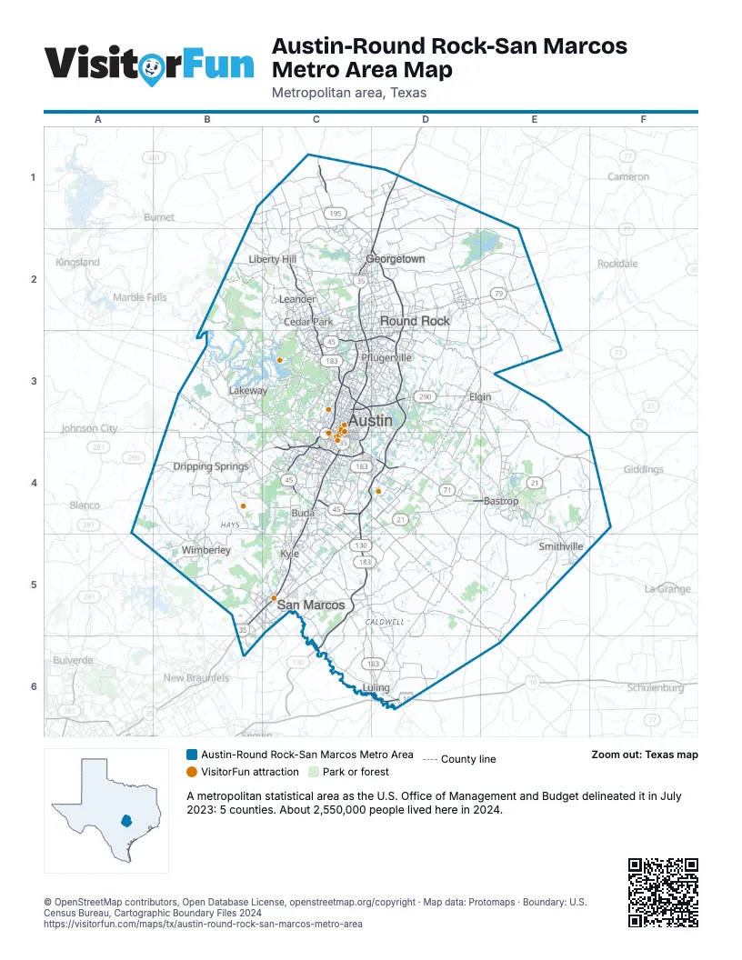
Highway index of Austin-Round Rock-San Marcos Metro Area
Each highway on the sheet and the grid squares it crosses.
- I-10D6
- I-35B5, C2, C3, C4, C5, D1, D2
- US 79C2, D2, E2
- US 90D6
- US 183C1, C2, C3, C4, C5, C6, D6
- US 290B4, C3, C4, D3, E3, E4, F4
- FM 20C5
- TX 21C5, D4, E4, F4
- TX 45C3, C4, D3, D4
- TX 71C4, D4, E4, E5
- TX 80C5, D6
- TX 95D3, E3, E4
- TX 130C4, C5, C6, D2, D3, D4
- TX 142C5
- SH 195C1
- TX 195C1, C2, D2
- FM 397D2
- FM 1660D2
- RM 2222C3
Things to do on the Austin-Round Rock-San Marcos Metro Area map
- ACL Live at the Moody Theater
- Barton Springs Pool
- Blanton Museum of Art
- Buescher State Park
- Bullock Texas State History Museum
- Circuit of The Americas
- Congress Avenue Bridge Bats
- Elisabet Ney Museum
- Franklin Barbecue
- Hippie Hollow Park
- Lady Bird Lake Hike-and-Bike Trail
- Lake Travis Zipline Adventures
- LBJ Presidential Library
- Lone Star Riverboat Bat Cruise
- Lundberg Bakery
- McKinney Falls State Park
- Meadows Center for Water and the Environment
- Mount Bonnell
- Museum of the Weird
- Neill-Cochran House Museum
- Salt Lick BBQ
- Sixth Street Entertainment District
- South Congress Avenue
- Tanger Outlets San Marcos
- Texas Historical Commission State Historic Sites
- Texas Military Forces Museum
- Texas State Capitol
- Texas State Cemetery
- Texas Travel Information Center
- The Contemporary Austin
- The Domain
- Zilker Park
Places on the map
- Austin
- Bastrop
- Buda
- Cedar Park
- Dripping Springs
- Elgin
- Georgetown
- Kyle
- Lakeway
- Leander
- Liberty Hill
- Luling
- Pflugerville
- Round Rock
- San Marcos
- Smithville
- Wimberley
© OpenStreetMap contributors, Open Database License, openstreetmap.org/copyright · Map data: Protomaps · Boundary: U.S. Census Bureau, Cartographic Boundary Files 2024