

Texas map
Fort Worth map
About 1,008,106 people live here (Census Bureau, 2024 estimate). The sheet's index lists 21 streets; I 35W TEXpress, North Freeway and Ronald Reagan Memorial Highway cross the most grid squares. Things to do inside the boundary: Amon Carter Museum of American Art, Bass Performance Hall and Billy Bob's Texas.
Open the map (PDF, US Letter)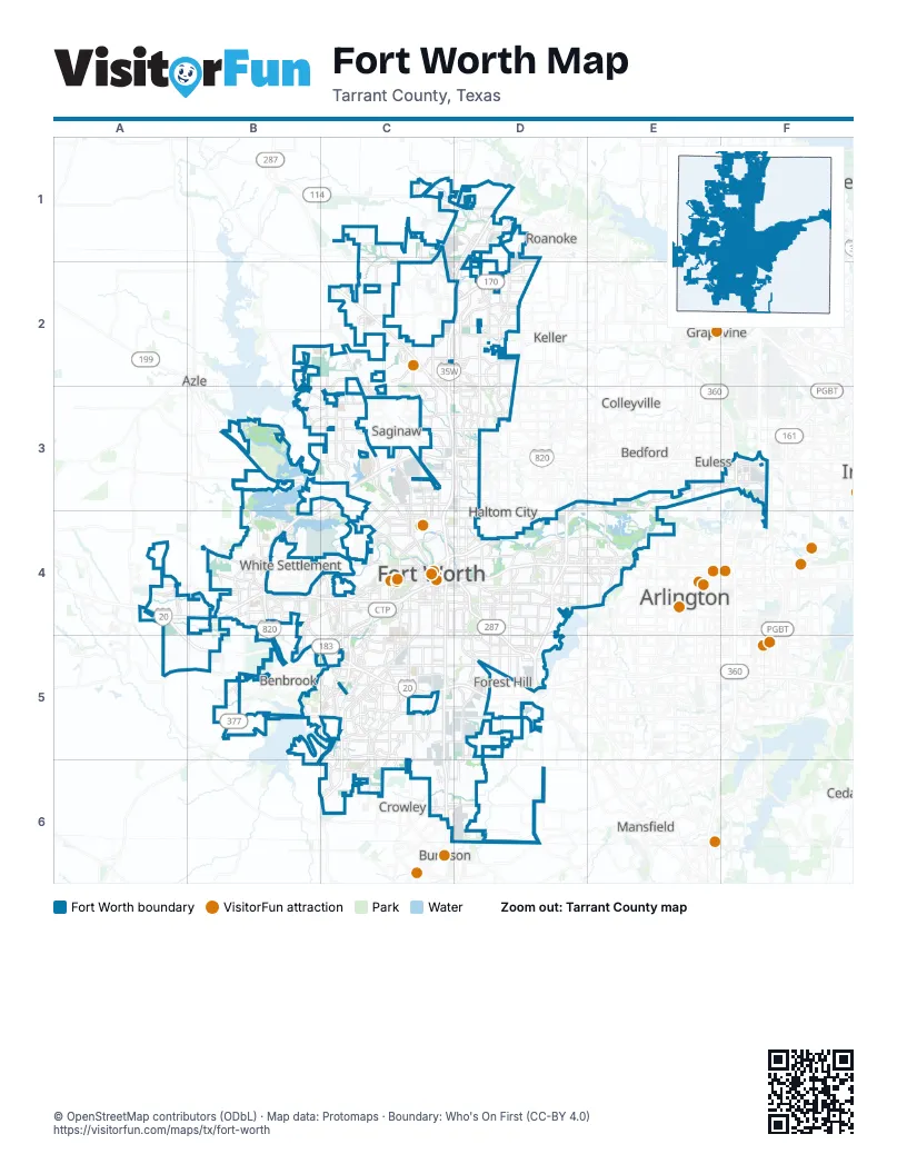
Street index of Fort Worth
Each street on the sheet and the grid squares it crosses.
- I 35W TEXpressD1, C2, D2, C3, D3, C4
- North FreewayD1, C2, D2, C3, D3, C4
- North Freeway Frontage RoadC2
- Alliance Gateway FreewayD2
- Jacksboro HighwayB3
- I 820 TEXpressC3, D3
- Jim Wright FreewayC3, B4
- Northeast LoopC3, D3
- Airport FreewayF3, C4, D4
- International ParkwayF3
- SH 183 TEXpressF3
- Ronald Reagan Memorial HighwayA4, A5, B5, C5, D5
- West FreewayA4, B4, C4
- Chisholm Trail ParkwayC4, C5, C6
- East Belknap StreetC4
- East Weatherford StreetC4
- Martin Luther King Jr FreewayC4, D4, D5
- North South FreewayC4
- South FreewayC4, C5, C6
- Tom Landry FreewayC4, D4, E4
- Southwest BoulevardB5, C5
Things to do on the Fort Worth map
- Amon Carter Museum of American Art
- Bass Performance Hall
- Bureau of Engraving and Printing Fort Worth
- DFW Car and Toy Museum
- Fort Worth Cultural District
- Fort Worth Stockyards National Historic District
- Fort Worth Water Gardens
- Fort Worth Zoo
- Kimbell Art Museum
- Modern Art Museum of Fort Worth
- National Multicultural Western Heritage Museum
Places on the map
- Alliance Intermodal Facility
- Alliance Town Center
- Arcadia Trail Park
- Beechwood Creeks
- BNSF Corporate HQ
- Bomber Heights
- Buck Sansom Park
- Camelot
- Candleridge Park
- Carter Park
- Chadwick Farms
- Chapel Hill
- Chisholm Trail Ranch
- Circle Drive
- Cobb Park
- Colonial Country Club
- Coventry
- Creekwood
- Dorado Ranch
- Eagle Ranch
- Far Southwest
- Fort Worth
- Fort Worth Nature Center & Refuge
- Fort Worth Southeast Landfill
- Fort Worth Water Gardens
- Fort Worth Yard
- Gateway Park
- Hallmark
- Hulen Heights
- Hyde Ranch Logistics Park
- La Prelle
- Lake Worth
- Lakes of River Trails North
- Lost Creek Golf Club
- Madero (Future Development)
- Mallard Cove Park
- Marine Creek Lake
- Marine Creek Lake Park
- Marion Sansom Park
- Mosque Point Park
Next to Fort Worth
- Arlington map
- Azle
- Bedford
- Benbrook
- Burleson
- Colleyville
- Coppell
- Crowley
- Euless
- Flower Mound
- Forest Hill
- Grand Prairie
- Grapevine
- Haltom City
- Hurst
- Keller
- Lewisville
- Mansfield
- North Richland Hills
- Roanoke
- Saginaw
- Southlake
- Westlake
- White Settlement
© OpenStreetMap contributors (ODbL) · Map data: Protomaps · Boundary: Who's On First (CC-BY 4.0)