

Texas map
Galveston map
About 53,538 people live here (Census Bureau, 2024 estimate). The sheet's index lists 300 streets; San Luis Pass Road, Seawall Boulevard and Stewart Road cross the most grid squares. Things to do inside the boundary: Moody Gardens, Galveston Helicopters and Galveston Island Historic Pleasure Pier.
Open the map (PDF, US Letter)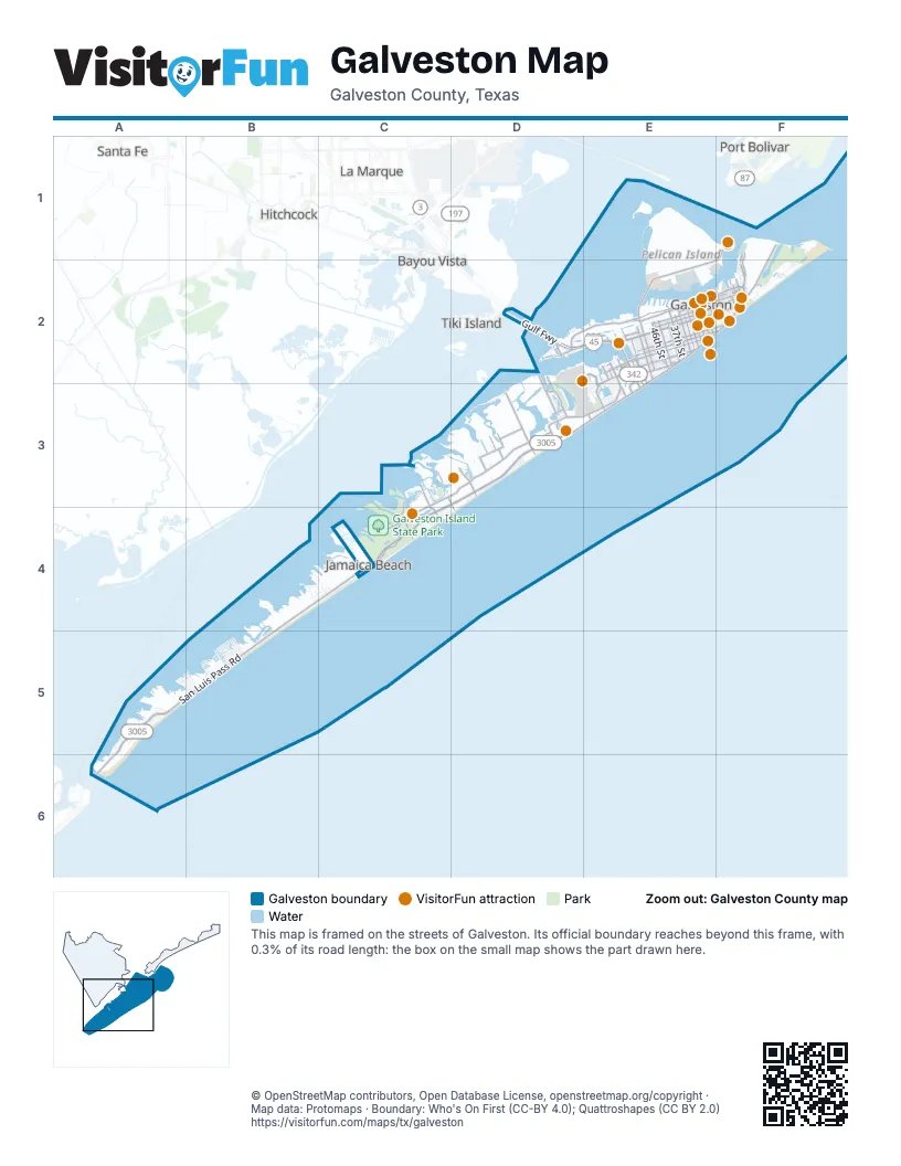
Street index of Galveston
Each street on the sheet and the grid squares it crosses.
- Gulf FreewayD2, E2
- San Luis Pass RoadD3, B4, C4, A5, B5, A6
- Termini San Luis Pass RoadD3, C4
- Seawall BoulevardF1, E2, F2, D3, E3
- Broadway - Avenue JE2, F2
- Harborside DriveD2, E2, F2
- 61st StreetE2, E3
- Rosenberg Avenue - 25th StreetE2
- Ferry RoadF1, F2
- Port Industrial RoadE2
- San Luis Pass-Vacek Toll BridgeA6
- University Boulevard - 6th StreetF2
- 61st StretE2
- Stewart RoadE2, C3, D3, E3, C4
- Broadway StreetD2, E2
- Avenue OE2, F2
- Seawolf ParkwayF1, E2, F2
- Avenue PE2
- Avenue SE2
- 37th StreetE2
- Mary Moody Northern Boulevard - 53rd StreetE2
- Market StreetE2, F2
- 45th StreetE2
- Pelican Island CausewayE2
- Martin Luther King Boulevard - 29th StreetE2
- 51st StreetE2
- Mike Gaido Boulevard - 39th StreetE2
- Moody Avenue - 21st StreetE2
- 31st StreetE2
- 14th StreetF2
- Jones DriveE2, E3
- Bernardo De Galvez AvenueE2, F2
- 81st StreetD2, E3
- Broadway AvenueE2
- Church Street - Avenue FE2, F2
- Park Road 66C3, C4
- Avenue QE2
- Ball Street - Avenue HE2
- 8 Mile RoadD3
- 33rd StreetE2
- 43rd StreetE2
- 59th StreetE2, E3
- 57th StreetE2
- 35th StreetE2
- Tremont Avenue - 23rd StreetE2
- 103rd StreetD2, D3
- 27th StreetE2
- Avenue UE2
- Cove View BoulevardD3
- Hope BoulevardE2, E3
- The StrandE2, F2
- 46th StreetE2
- 19th StreetE2, F2
- Heards LaneE2
- Teichman RoadD2
- Central City BoulevardE2, E3
- 15th StreetF2
- 99th StreetD3
- 65th StreetE2
- 69th StreetE2, E3
- 11 Mile RoadC3, D3, D4
- Buccaneer BoulevardC3, C4
- 9 Mile RoadD3
- Ostermeyer RoadD3
- Highway 168F1, F2
- Homrighaus RoadD3
- 13 Mile RoadC4
- Spanish Main BoulevardD3
- Market Street - Avenue DE2
- Blume DriveD2
- Travel Air RoadD2, D3
- Saint Mary's Boulevard - 8th StreetF2
- 73rd StreetE2
- Pabst RoadD3
- 10 Mile RoadD3
- Zingelman RoadD3
- 71st StreetE2
- Holiday Drive - 4th StreetF2
- 12 Mile RoadC3
- Avenue T ½E2
- Holiday DriveF2
- Schaper RoadD3
- Carthegena WayC3
- 7 ½ Mile RoadD3
- 7 Mile RoadD3
- Cloud LaneD3
- Saladia StreetE2
- Darrell Royal AvenueF2
- Texas AvenueF2
- Lewis LaneD2
- Santa Fe PlaceE2
- 89th StreetE3
- Avenue LE2, F2
- Avenue KE2, F2
- Sealy Street - Avenue IE2, F2
- Avenue ME2, F2
- Avenue Q ½E2
- Winnie Street - Avenue GE2, F2
- Avenue RE2
- Apffel Park RoadF2
- Avenue O ½E2, F2
- Avenue N ½E2, F2
- Avenue M ½E2, F2
- Avenue P ½E2
- Postoffice StreetE2, F2
- Avenue R ½E2
- Ursuline StreetE2, F2
- East Beach DriveF2
- Gulf DriveB5
- Mechanic Street - Avenue CE2, F2
- Avenue S ½E2
- Bob Smith RoadC4
- Jack Johnson Boulevard - 41st StreetE2
- 52nd StreetE2
- 32nd StreetE2
- 28th StreetE2
- Sportsman RoadD3
- 54th StreetE2
- Kempner Avenue - 22nd StreetE2
- 30th StreetE2
- Avenue HE2, F2
- 20th StreetE2, F2
- 18th StreetE2, F2
- Shores DriveB4, B5
- 17th StreetE2, F2
- Boddecker RoadF1
- 40th StreetE2
- 16th StreetE2, F2
- Avenue TE2
- 38th StreetE2
- 48th StreetE2
- 83rd StreetE2, E3
- Indian Beach DriveB4, C4
- 26th StreetE2
- 47th StreetE2
- 50th StreetE2
- Beluche DriveE2, E3
- 13th StreetF2
- 55th StreetE2
- 44th StreetE2
- 34th StreetE2
- Dominique DriveE3
- 77th StreetD2, E2, E3
- 49th StreetE2
- 42nd StreetE2
- Bay Water DriveA5
- Shaman DriveB4, C4
- 12th StreetF2
- 5th StreetF2, A5, B5
- Fort Bend DriveB5
- 36th StreetE2
- 56th StreetE2
- Pirates Beach BoulevardC4
- Estuary DriveA5, A6
- 11th StreetF2
- Settegast RoadC3, D3
- Jolly Roger RoadC4
- Sydnor LaneD3
- Fort Crockett BoulevardE2
- Postoffice Street - Avenue EE2
- 1st StreetF2, B5
- Grand TerreC4, D4
- San Domingo DriveC4
- Kiva RoadB4
- Mutiny LaneC4
- Ursuline Street - Avenue NE2, F2
- 24th StreetE2
- Bayou Shore DriveE2
- Las Palmas StreetC4
- Marine DriveF2
- Nueces DriveB5
- Pine StreetE2, E3
- Grambo BoulevardC3
- Warrior RoadB4, C4
- 9th StreetF2
- 10th StreetF2
- Wharf RoadE2, F2
- Island PassageD3
- South Sunset Bay DriveB4, B5
- Marina BoulevardC4
- Terminal DriveE2, E3
- 7th StreetF2, A5, B5
- Mitote DriveB4, C4
- Eckert DriveC3
- San Jacinto DriveF2, B5
- Mitchell Avenue - 24th StreetE2
- Todd RoadE2
- Bermuda Beach RoadD3
- Sherman BoulevardE2
- Driftwood LaneE2
- 6th StreetA5, B5
- Galceran DriveA5, B5
- 4th StreetA5, B5
- Bay Breeze DriveA5
- Zachary DriveB5
- Verano DriveB5
- Christmas Tree Point RoadC3
- BeachsideD3
- 91st StreetD2
- Camino StreetB5
- Cove LaneC3
- Terramar DriveB5
- Lampasas DriveB5
- Colony Park CircleE2, E3
- Fresca StreetB5
- John Reynolds RoadD3
- Cat TrailA5
- Rattlesnake RoadE2
- Bradner RoadE2
- Frio DriveB5
- 3rd StreetB5
- 2nd StreetB5
- Grand Beach BoulevardF2
- Deaf Smith DriveB5
- Guadalupe DriveB5
- Windlass CircleC3
- Cedar Lawn CircleE2
- Lockheed RoadE2, E3
- Adler CircleE2
- Woodrow AvenueE2
- 63rd StreetE2
- Spotted Sandpiper DriveA5
- Intrepid LaneA5
- Monterry DriveA5
- Mendocino DriveA5
- Borden AvenueE2
- East Sunset Bay DriveB4, B5
- East Kahala DriveB4
- Matagorda DriveB5
- Harbor View DriveF2
- Buena StreetB5
- Isla del Sol DriveB5
- Concho KeyB5
- Airport BoulevardE3
- Silver Reef CourtC4
- Evia MainD3
- Beech StreetE2, E3
- Navarro DriveB5
- Panola DriveB5
- Reeves DriveB5
- Denver DriveE2
- West Sunset Bay DriveB5
- Flamingo DriveA5
- Cessna DriveE3
- Campeche DriveD3
- Caduceus PlaceE2
- Kleinmann AvenueE3
- East de Vaca LaneC4
- 67th StreetE2
- Mason DriveB5
- Backbay CircleE2
- Surf DriveC4
- GafftoppersD3
- Beaudelaire CircleE3
- Jenkins RoadD3
- Chantilly CircleE3
- Ector DriveB5
- Grayson DriveB5
- Foremast DriveC3
- NOAAE2
- Vista BoulevardC4
- Great Blue Heron DriveA5
- Hardin DriveB5
- Jackson DriveB5
- Kent DriveB5
- Teramar BeachB5
- SwashbuckleC4
- Dana DriveC4
- Salt Prairie DriveA5
- Bayou Homes DriveE2
- Porch StreetD3
- El LagoC4
- Pennzoil RoadE2
- Tradewinds DriveD3, A5, B5
- Glossy Ibis WayA5
- Grand AvenueD3
- Lakeview DriveE3
- Sky Master RoadE2, E3
- Lafitte's PointC3
- Sausalito DriveA5
- Sea ButterflyD3
- Sunbather LaneD3
- 75th StreetE3
- Shelby Drive SouthB5
- Shelby Drive NorthB5
- Liberty DriveB5
- Crockett BoulevardE2
- Menard AvenueE2
- Golf Crest DriveE2
- Port Trinidad RoadB5
- Biovu DriveE2
- Quintana DriveD3
- Homer RoadD3
- Lebrun CourtE3
- North Cedar Lawn DriveE2
- South Cedar Lawn DriveE2
- Fairway DriveE2
- Hamilton RoadC3
- Pruitt DriveD2
- San Marino DriveF2
Things to do on the Galveston map
- Moody Gardens
- Galveston Helicopters
- Artist Boat
- Benno's Cajun Seafood
- Bishop's Palace
- Edward and Helen Oppenheimer Bird Observatory
- Galveston Duck Tours
- Galveston Naval Museum (USS Cavalla)
- Galveston Party Boats
- Galveston Railroad Museum
- Hal Newsom's Airboat Tours
- Juneteenth and Beyond Guided Tours
- Seawolf Park
- The Bryan Museum
- The Grand 1894 Opera House
- The Strand Historic District
- Wave Dancer Charters
Places on the map
- 1892 Bishop's Palace
- Babe's Beach
- Ball High School
- Broadway Center
- Calvary Cemetery
- Campeche Lake
- Coast Guard Mooring Basin
- Courville Stadium
- Crane Hill Soccer Complex
- Dellanera RV Park
- East Beach
- East End Lagoon Nature Perserve
- Galveston Beach
- Galveston City Hall
- Galveston Island KOA Holiday
- Galveston Island State Park
- Galveston Place
- Galveston Yacht Marina, A-Dock
- Galveston Yacht Marina, B-Dock
- Galveston Yacht Marina, C-Dock
- Galveston Yacht Marina, D-Dock
- Galveston-Port Bolivar Ferry
- Galvez Shopping Center
- Holiday Inn Club Vacations Galveston Seaside Resort
- Jamaica Beach RV Resort
- John Sealy Hospital
- Lake Madeline
- Moody Gardens
- Moody Gardens Golf Course
- Pirates' Beach
- Porretto Beach
- Port of Galveston
- San Jacinto PA
- San Luis Beach
- Schreiber Park
- Stella Mare RV Resort
- Stewart Beach
- Sunny Beach
- Texas Campgrounds Club
- West Beach
Next to Galveston
- Arcadia
- Bayou Vista
- Hitchcock
- Jamaica Beach
- La Marque map
- Port Bolivar
- Santa Fe map
- Tiki Island
© OpenStreetMap contributors, Open Database License, openstreetmap.org/copyright · Map data: Protomaps · Boundary: Who's On First (CC-BY 4.0); Quattroshapes (CC BY 2.0)















