

Texas map
Travis County map
About 1,363,767 people live here (Census Bureau, 2024 estimate). The sheet's index lists 16 streets; Pickle Parkway, Purple Heart Trail and North Mopac Expressway cross the most grid squares. Things to do inside the boundary: ACL Live at the Moody Theater, Barton Springs Pool and Blanton Museum of Art.
Open the map (PDF, US Letter)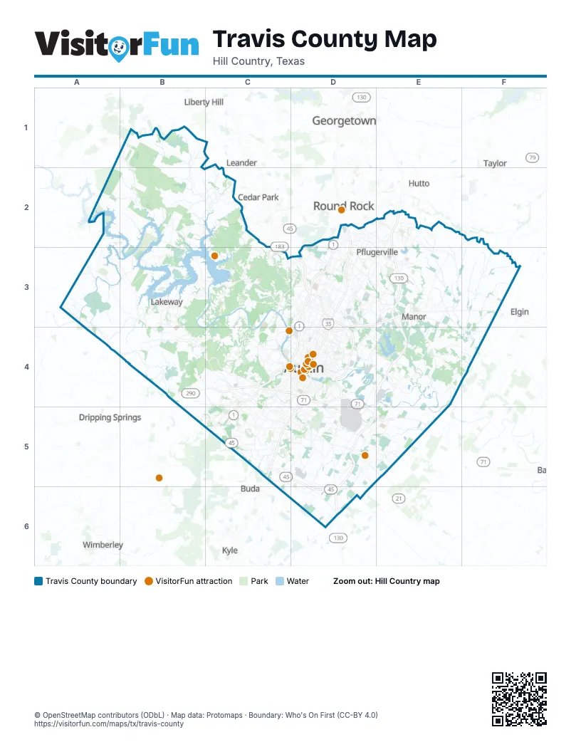
Maps inside Travis County
1 map inside, from the street map of Travis County down.
Street index of Travis County
Each street on the sheet and the grid squares it crosses.
- North Mopac ExpresswayD2, D3, C4, D4
- Purple Heart TrailD2, D3, D4, C5, D5
- State Highway 45 NorthD2, E2
- Pickle ParkwayE2, E3, D4, E4, D5, E5, D6
- Manor ExpresswayD3, E3, D4
- East US Highway 290E3
- South Capital of Texas HighwayC4
- South Mopac ExpresswayC4, C5
- West US Highway 290C4
- Bastrop HighwayD4, E5
- Bergstrom ExpresswayD4
- East Ben White BoulevardD4
- 45 Southwest Toll RoadC5
- State Highway 45 SoutheastC5, D5, D6
- Bastrop FreewayD5, E5
- Texas State Highway 71E5
Things to do on the Travis County map
- ACL Live at the Moody Theater
- Barton Springs Pool
- Blanton Museum of Art
- Bullock Texas State History Museum
- Circuit of The Americas
- Congress Avenue Bridge Bats
- Franklin Barbecue
- Lady Bird Lake Hike-and-Bike Trail
- Lake Travis Zipline Adventures
- LBJ Presidential Library
- Lone Star Riverboat Bat Cruise
- Mount Bonnell
- Museum of the Weird
- Sixth Street Entertainment District
- South Congress Avenue
- Texas Historical Commission State Historic Sites
- Texas State Capitol
- Texas Travel Information Center
- Zilker Park
Places on the map
- Angus Valley
- Arkansas Bend Park
- Arroyo Doble
- Arroyo Doble Estates
- Austin
- Austin Golf Course
- Austin State Hospital
- Austin Wood Recycling
- Austin-Bergstrom International Airport
- Austin's Colony
- Baker Sanctuary
- Balcones Canyonlands National Wildlife Refuge
- Balcones Country Club
- Barker Ranch at Shady Hollow
- Barkley Meadows Park
- Barton Creek Fazio Canyons
- Barton Creek Fazio Foothills
- Barton Creek Habitat Preserve
- Barton Creek Square
- Barton Hills
- Bauerle Ranch
- Beaconridge
- Bear Creek Management Unit
- Bee Cave
- Bellingham Meadows
- Blackhawk Golf Club
- Blackhawk Greenbelt
- Bohl's Place
- Boulder Ridge
- Bradshaw Crossing
- Briarcliff
- Briarcreek
- Briarwood
- Bridges of Bear Creek
- Bright Leaf Natural Area
- Bryant Park at Easton Park
- Buckingham Estates
- Buckingham Ridge
- Camp Mabry
- Cantarra
Next to Travis County
- Buda
- Cedar Park
- Dripping Springs
- Elgin
- Georgetown
- Hutto
- Kyle
- Leander
- Liberty Hill
- Round Rock
- Taylor
- Wimberley
© OpenStreetMap contributors (ODbL) · Map data: Protomaps · Boundary: Who's On First (CC-BY 4.0)