

Utah map
Salt Lake City map
About 217,783 people live here (Census Bureau, 2024 estimate). The sheet's index lists 48 streets; Dwight D. Eisenhower Highway, Belt Route and Terminal Drive cross the most grid squares. Things to do inside the boundary: City Sights Tours, Clark Planetarium and Delta Center.
Open the map (PDF, US Letter)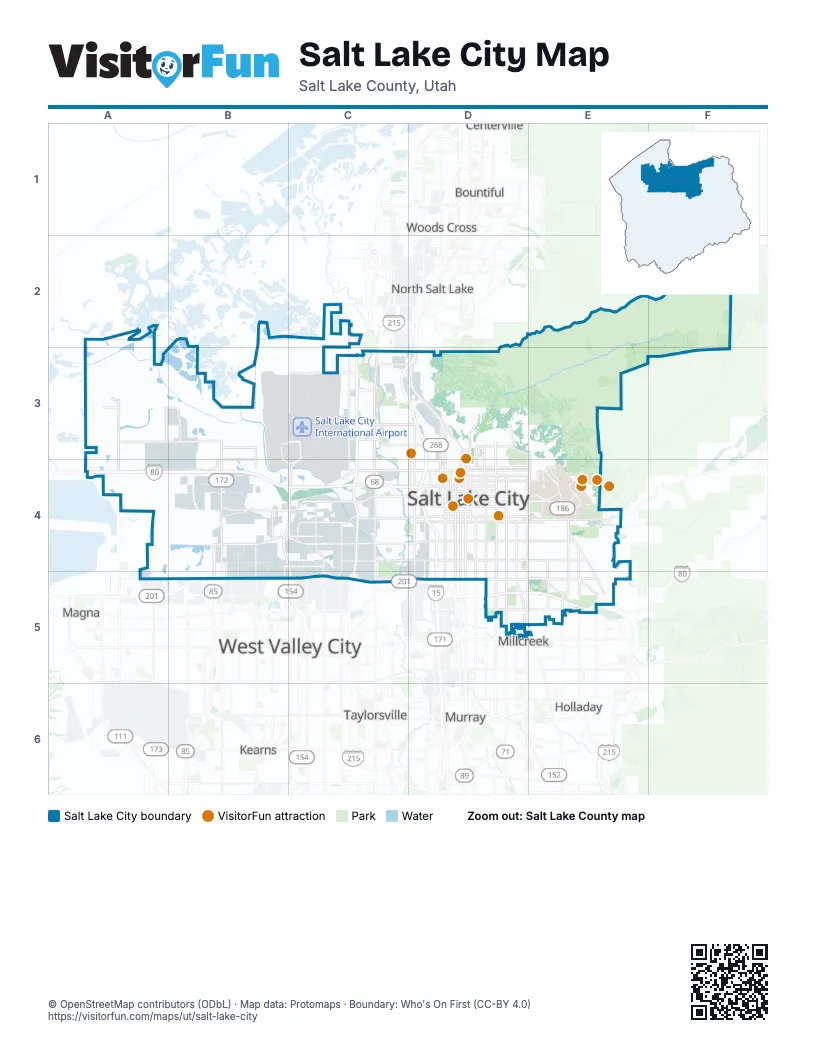
Street index of Salt Lake City
Each street on the sheet and the grid squares it crosses.
- Belt RouteC2, C3, C4, C5
- Terminal DriveB3, C3, B4, C4
- 600 NorthC3, D3
- 700 NorthC3
- Redwood RoadC3, C4, C5
- Veterans Memorial HighwayC3, D3, D4, D5
- 300 WestD3, D4, D5
- 900 WestD3, D4, D5
- Beck StreetD3
- Columbus StreetD3, D4
- Highway 89D3
- Victory RoadD3
- Dwight D. Eisenhower HighwayA4, B4, C4, D4, D5, E5
- 5600 WestB4, B5
- Bangerter HighwayB4, C4, C5
- California AvenueB4, C4, D4
- Mountain View CorridorB4, B5
- 400 SouthC4, D4
- North TempleC4, D4
- Pioneer RoadC4, C5
- 100 SouthD4, E4
- 1300 EastD4, D5, E5
- 1300 SouthD4
- 300 NorthD4
- 500 SouthD4, E4
- 600 SouthD4
- 700 EastD4, D5
- 800 SouthD4, E4
- Jefferson StreetD4
- South TempleD4
- State StreetD4
- West TempleD4
- 2100 EastE4
- Emigration Canyon RoadE4
- Foothill DriveE4, E5
- Mario Capecchi DriveE4
- North Campus DriveE4
- Sunnyside AvenueE4
- 2100 South FreewayB5, C5
- 2100 SouthC5, D5, E5
- 2760 WestC5
- 3230 WestC5
- 3300 SouthD5
- Highland DriveD5
- Richmond StreetD5
- 2300 EastE5
- Parleys WayE5
- Vimont AvenueE5
Things to do on the Salt Lake City map
Places on the map
- 300 West Town Center
- All Seasons
- AMSCO Windows
- Baileys Lake
- Ballpark
- Bonneville Golf Course
- Brickyard Condominiums
- Brickyard Shopping Plaza
- Brighton Canal
- Capitol Hill
- Central City
- Central Ninth
- City Creek Center
- Concourse A
- Concourse B
- Copart
- Downtown
- East Bench
- East Central
- East High School
- East Liberty Park
- Ensign Peak
- Fairpark
- Foothill / Sunnyside
- Foothill Place Apartments
- Foothill Village
- Forest Dale Golf Course
- Fort Douglas (historic)
- Gadsby Power Plant
- Glendale
- Glendale Golf Course
- Glendale Park Expansion
- Granary District
- Greater Avenues
- Hogle Zoo
- Huntsman Cancer Hospital
- J. Willard Marriott Library
- Jordan Meadows
- Jordan Park
Next to Salt Lake City
- Bountiful
- Centerville
- Holladay
- Kearns
- Magna
- Millcreek
- Murray
- North Salt Lake
- South Salt Lake
- Taylorsville
- West Valley City
- Woods Cross
© OpenStreetMap contributors (ODbL) · Map data: Protomaps · Boundary: Who's On First (CC-BY 4.0)