

Virginia map
Virginia Beach-Chesapeake-Norfolk Metro Area map
The sheet's index lists 29 highways; US 17, I-64 and US 13 cross the most grid squares. Things to do inside the boundary: Barry Art Museum, Busch Gardens Williamsburg and Cape Henry Lighthouse. Also on it: Chesapeake, Gloucester and Newport News.
Open the map (PDF, US Letter)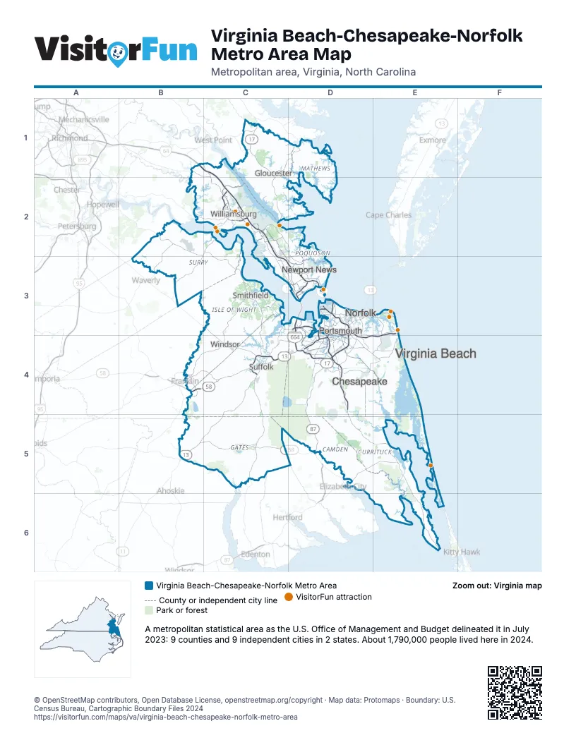
Highway index of Virginia Beach-Chesapeake-Norfolk Metro Area
Each highway on the sheet and the grid squares it crosses.
- I-64B1, C1, C2, C3, D3, D4
- I-264D3, D4, E3, E4
- I-464D4
- I-564D3
- I-664D3, D4
- US 13B5, C4, C5, D3, D4
- US 17C1, C2, C3, D2, D3, D4, D5
- US 58B4, C4, D3, D4
- US 60D3, E3
- US 158B5, C5, D5, E5, E6
- US 258B4, C3, D3
- US 460C3, C4, D3, D4
- VA 5B2, C2
- VA 10B2, C2, C3, C4
- VA 14C1
- VA 31B2, C2
- VA 32C3, C4, D3
- VA 33C1
- VA 44E3
- VA 134D3
- VA 164D3, D4
- VA 165D4, E4
- VA 166D3
- NC 168D5, E5
- VA 168D3, D4, D5
- VA 189B4, C4
- VA 199C2
- VA 225D3, D4
- VA 337D3, D4
Things to do on the Virginia Beach-Chesapeake-Norfolk Metro Area map
- Barry Art Museum
- Busch Gardens Williamsburg
- Cape Henry Lighthouse
- Chesapeake Square Mall
- Children's Museum of Virginia
- Chippokes State Park
- Chrysler Museum of Art
- Colonial Williamsburg
- False Cape State Park
- First Landing State Park
- Fort Boykin
- Fort Huger
- Fort Monroe
- Hampton National Cemetery
- Hampton University Museum
- Historic Jamestowne
- Isle of Wight County Museum
- Jamestown Settlement
- Lynnhaven Mall
- MacArthur Memorial
- Machicomoco State Park
- Military Aviation Museum
- Moses Myers House
- Muscarelle Museum of Art
- Norfolk Botanical Garden
- The Mariners' Museum and Park
- Virginia Air and Space Science Center
- Virginia Aquarium & Marine Science Center
- Virginia Beach Boardwalk
- Virginia Beach Surf & Rescue Museum
- Virginia Living Museum
- Virginia Zoological Park
- York River State Park
- Yorktown Battlefield
- Yorktown National Cemetery
Places on the map
- Chesapeake
- Gloucester
- Newport News
- Norfolk
- Portsmouth
- Smithfield
- Suffolk
- Virginia Beach
- Williamsburg
- Windsor
© OpenStreetMap contributors, Open Database License, openstreetmap.org/copyright · Map data: Protomaps · Boundary: U.S. Census Bureau, Cartographic Boundary Files 2024