

Georgia map
Historic Heartland map
The sheet's index lists 37 highways; US 129, US 441 and I-75 cross the most grid squares. Things to do inside the boundary: Andalusia, Cannonball House and Dauset Trails Nature Center. Also on it: Athens, Barnesville and Conyers.
Open the map (PDF, US Letter)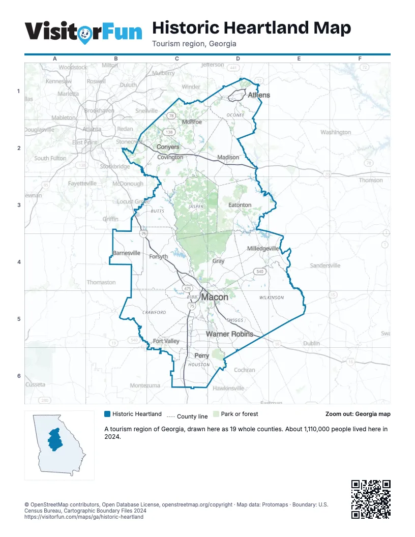
Highway index of Historic Heartland
Each highway on the sheet and the grid squares it crosses.
- I-16C4, C5, D5
- I-20B2, C2, D2
- I-75B3, B4, C4, C5, C6
- I-475C4, C5
- US 23C4, D4, D5
- US 29D1
- US 41C6
- US 78C1, C2, D1
- US 80C4, D4, D5
- US 129C4, D1, D2, D3, D4, D5
- US 278B2, C2
- US 341C6, D6
- US 441D1, D2, D3, D4, E4, E5
- GA 7C6
- GA 8D1
- GA 10C1, C2, D1
- GA 11C4, C6, D4, D6
- GA 12B2, C2
- GA 15D1
- GA 18D4
- GA 19C4, D4, D5
- GA 20C2
- GA 22C4, D4
- GA 24D1, D2, D3, D4, E4
- GA 29D4, E4, E5
- GA 44D3, D4
- GA 49C4, C5
- GA 57D4, D5
- GA 72D1
- GA 81C1
- GA 87C4, D4, D5
- GA 96C5, D5
- GA 127C6
- GA 138B2, C2
- GA 224C6
- GA 316D1
- GA 540C4, C5, D4, D5, E4
Things to do on the Historic Heartland map
- Andalusia
- Cannonball House
- Georgia's Old Capital Heritage Center at The Depot
- Heritage Hall
- Indian Springs State Park
- Monroe Museum
- Museum of Arts and Sciences
- Museum of Aviation
- Ocmulgee Mounds National Historical Park
- Old Governor's Mansion
- Panola Mountain State Park
- Rock Eagle Effigy Mound
- Rock Hawk Effigy & Trails
- Telling Our Story Black History Museum
- The Shoppes at River Crossing
- Tubman African American Museum
- Uncle Remus Museum
- William P. Wall Museum of Natural History
Places on the map
- Athens
- Barnesville
- Conyers
- Covington
- Eatonton
- Forsyth
- Fort Valley
- Gray
- Macon
- Madison
- Milledgeville
- Monroe
- Perry
- Warner Robins
Next to Historic Heartland
© OpenStreetMap contributors, Open Database License, openstreetmap.org/copyright · Map data: Protomaps · Boundary: U.S. Census Bureau, Cartographic Boundary Files 2024