

Georgia map
Presidential Pathways map
The sheet's index lists 30 highways; US 27, US 280 and GA 1 cross the most grid squares. Things to do inside the boundary: Andersonville National Cemetery, Andersonville National Historic Site and Callaway Resort & Gardens. Also on it: Americus, Columbus and Cordele.
Open the map (PDF, US Letter)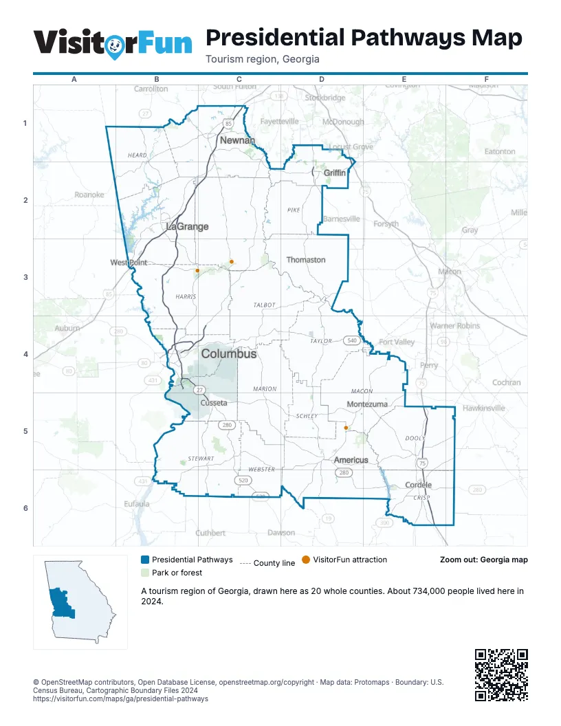
Highway index of Presidential Pathways
Each highway on the sheet and the grid squares it crosses.
- I-75D2, E5, E6
- I-85B2, B3, C1, C2
- I-185B2, B3, B4
- US 19D1, D2, D3, D4, D5, D6
- US 27B1, B2, B3, B4, C4, C5, C6
- US 29B2
- US 41D1, D2
- US 80B4, C4, D3
- US 280B4, C4, C5, D5, D6, E6, F6
- GA 1B1, B2, B3, B4, C4, C5, C6
- GA 3D1, D2, D3, D4, D5, D6
- GA 14B2
- GA 22B4, C4, D3
- GA 27C5, D5, D6
- GA 30D5, D6, E6, F6
- GA 41C4
- GA 49D5
- GA 85B4, C4
- GA 90C4, D4, E6
- GA 92D2
- GA 96C4, D4, E4
- GA 100B2
- GA 109B2, D2
- GA 127D4
- GA 137D4
- GA 195D6
- GA 219B2
- GA 300E6
- GA 520B4, C4, C5, C6
- GA 540B4, C4, D4, E4
Things to do on the Presidential Pathways map
- Andersonville National Cemetery
- Andersonville National Historic Site
- Callaway Resort & Gardens
- Drummer Boy Civil War Museum
- F. D. Roosevelt State Park
- Florence Marina State Park
- National Civil War Naval Museum at Port Columbus
- National Infantry Museum & Soldier Center
- Peachtree Mall
- Providence Canyon State Park
- Roosevelt's Little White House
- Sprewell Bluff Park
Places on the map
- Americus
- Columbus
- Cordele
- Cusseta
- Griffin
- LaGrange
- Montezuma
- Newnan
- Thomaston
- West Point
Next to Presidential Pathways
- Central Alabama
- South Alabama
- Atlanta Metro map
- Historic Heartland map
- Magnolia Midlands map
- Northwest Georgia map
- Scenic Southwest Georgia map
© OpenStreetMap contributors, Open Database License, openstreetmap.org/copyright · Map data: Protomaps · Boundary: U.S. Census Bureau, Cartographic Boundary Files 2024