

Georgia map
Savannah map
About 148,808 people live here (Census Bureau, 2024 estimate). The sheet's index lists 86 streets; Ogeechee Road, William F. Lynes Parkway and Abercorn Street cross the most grid squares. Things to do inside the boundary: Bonaventure Cemetery, Cathedral Basilica of St. John the Baptist and Forsyth Park.
Open the map (PDF, US Letter)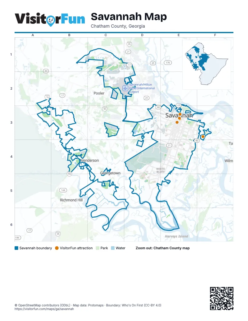
Street index of Savannah
Each street on the sheet and the grid squares it crosses.
- Jimmy Deloach ParkwayC1, D1
- Airways AvenueC2
- Gulfstream RoadC2, D2
- Pooler ParkwayC2
- Bourne AvenueD2
- Dean Forest RoadD2, C3, D3
- Main StreetD2
- Robert B Miller Jr RoadD2
- Robert B Miller RoadD2
- Robert B. Miller RoadD2
- West Bay StreetD2, D3, E3
- John Carter RoadA3
- Little Neck RoadB3
- Old Little Neck RoadB3
- Jim Gillis Historic Savannah ParkwayC3, D3, E3
- Alfred StreetD3
- Augusta AvenueD3, E3
- Chatham ParkwayD3
- Collins StreetD3, E3
- Fair StreetD3
- Louisville RoadD3, E3
- Mills B Lane BoulevardD3, E3
- Mills LaneD3
- Ogeechee RoadD3, E3, B4, C4
- West Gwinnett StreetD3, E3
- William F. Lynes ParkwayD3, E3, D4, E4
- 52nd St Access RoadE3
- Abercorn StreetE3, D4, E4, D5
- Atlantic Coastal HighwayE3
- Bee RoadE3, E4
- Bouhan StreetE3
- Drayton StreetE3
- East 31st StreetE3
- East 37th StreetE3
- East 52nd StreetE3, E4
- East Anderson StreetE3
- East Bay StreetE3
- East Broad StreetE3
- East Gwinnett StreetE3
- East Henry StreetE3
- East Lathrop AvenueE3
- East Liberty StreetE3
- East Oglethorpe AvenueE3
- East President StreetE3
- East Victory DriveE3
- Exchange StreetE3
- General McIntosh BoulevardE3
- Harmon StreetE3
- Harry Truman ParkwayE3, E4, D5, E5
- Martin Luther King Jr BoulevardE3
- Martin Luther King Junior BoulevardE3
- Montgomery StreetE3, E4
- Northbound Frontage RoadE3
- Pennsylvania AvenueE3
- Price StreetE3
- Skidaway RoadE3, E4
- Wallin StreetE3
- Waters AvenueE3, E4
- West 37th StreetE3
- West 52nd StreetE3
- West Anderson StreetE3
- West Boundary StreetE3
- West Henry StreetE3
- West Liberty StreetE3
- West Oglethorpe AvenueE3
- West Victory DriveE3
- Wheaton StreetE3
- Whitaker StreetE3
- Fort Argyle RoadB4
- Middleground RoadD4, D5
- Tibet AvenueD4, E4
- West Montgomery Cross RoadD4, E4
- White Bluff RoadD4, E4, D5
- Beaumont DriveE4
- Charles StreetE4
- Delesseps AvenueE4
- East Derenne AvenueE4
- East Montgomery Cross RoadE4
- Eisenhower DriveE4
- La Roche AvenueE4
- Waters DriveE4
- West de Renne AvenueE4
- West Derenne AvenueE4
- Wild Heron RoadC5
- Abercorn–White Bluff ConnectorD5
- New Coffee Bluff RoadD5
Things to do on the Savannah map
Places on the map
- Abercorn Commons
- Bacon Park Golf Course
- Blue Sky Preserve
- Bonaventure Cemetery
- Bradley Pointe Apartments
- Bradley Pointe South
- Catholic Cemetery
- Chatham County Jail
- Coastal State Prison
- Colonial Grand at Godley Lake
- Crosswinds Golf Club
- Daffin Park
- Dairy District
- Dean Forest Landfill
- Eastern Wharf
- Ella Island
- Encompass Health Rehab Hospital Of Savannah
- Forrest Hill
- Forsyth Park
- Frank O. Williamson Lake
- Georgia Regional Hospital
- Godley Station Middle School
- Greenwich Cemetery
- Greyfield Circle
- Highlands Crossing at Godley
- Hillcrest Abbey
- Horse Pen Swamp
- Hunter Army Airfield
- Jennifer Ross Sports Complex
- Joseph Tribble Park
- Lake Mayer Community Park
- Laurel Grove North Cemetery
- Laurel Grove South Cemetery
- Liberty Terminals
- Longshore Commons Apartments
- MAA Benton
- Marion Lakes
- Martin Marietta
- Mary Telfair Women's Hospital
- Mohawk Lake
Next to Savannah
- Dutch Island
- Georgetown
- Henderson
- Pooler
- Richmond Hill
© OpenStreetMap contributors (ODbL) · Map data: Protomaps · Boundary: Who's On First (CC-BY 4.0)