

Minnesota map
Ramsey County map
About 542,015 people live here (Census Bureau, 2024 estimate). The sheet's index lists 145 streets; Rice Street, Lexington Avenue North and County Road E East cross the most grid squares. Things to do inside the boundary: Bell Museum, Cathedral of Saint Paul and Como Park Zoo & Conservatory.
Open the map (PDF, US Letter)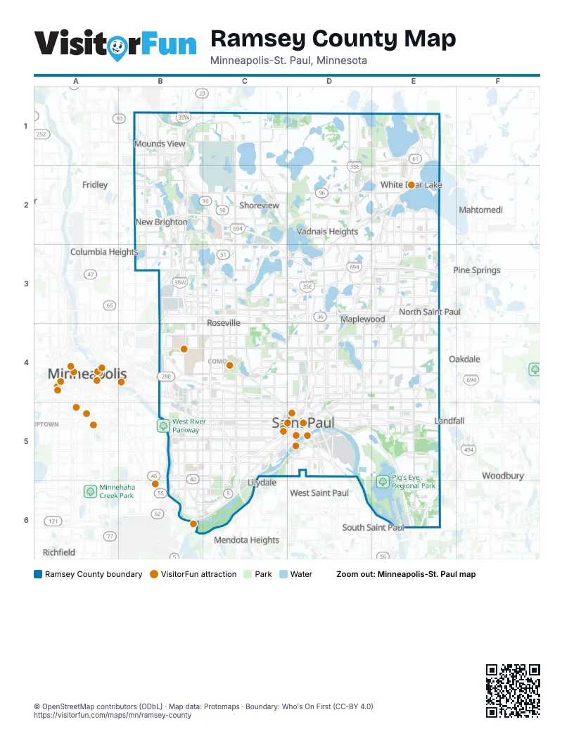
Maps inside Ramsey County
1 map inside, from the street map of Ramsey County down.
Street index of Ramsey County
Each street on the sheet and the grid squares it crosses.
- County Highway 10B1
- Mounds View BoulevardB1, B2
- Silver Lake RoadB1, B2, B3
- Hodgson RoadC1, C2
- Lexington Avenue NorthC1, C2, C3, C4
- Centerville RoadD1, D2
- Dellwood Road NorthE1
- Lake AvenueE1, E2
- County Highway 96B2, C2, D2
- Prior AvenueB2
- Silver Lake Road NorthwestB2, B3
- Grey Fox RoadC2
- Hamline Avenue NorthC2, C3
- Rice StreetC2, C3, D3, C4, D4, C5, D5
- County Road E EastD2, E2, D3, E3
- North Highway 61E2
- White Bear AvenueE2, E3
- 29th Avenue NortheastB3
- 37th Avenue NortheastB3
- County Road 88B3
- County Road D WestB3
- County Road D WestB3
- New Brighton BoulevardB3
- North Cleveland AvenueB3, B4, B5
- Saint Croix StreetB3
- Silver Lake Road NortheastB3
- Silver Lake Road SouthwestB3
- West County Road CB3, C3
- County Road CC3, D3
- Dale Street NorthC3, C4
- Snelling Avenue NorthC3, C4
- Connor AvenueD3
- East County Road CD3
- Little Canada Road EastD3
- Maplewood DriveD3
- North Maplewood DriveD3, D4
- Voyageur HighwayD3
- East County Line RoadE3
- Geneva Avenue NorthE3
- North Century AvenueE3, E4
- White Bear Avenue NorthE3, E4, E5
- Broadway StreetB4
- Como AvenueB4, C4, C5, D5
- Cromwell AvenueB4
- East Hennepin AvenueB4
- Larpenteur Avenue WestB4, C4, D4
- North Eustis StreetB4
- North Hunting Valley RoadB4
- Northeast Broadway StreetB4
- Pierce Butler RouteB4, C4
- Transfer RoadB4, B5
- University Avenue WestB4, B5, C5, D5
- Dale StreetC4, C5
- Lexington Parkway NorthC4, C5
- Maryland Avenue WestC4, D4
- Minnehaha AvenueC4
- North Lexington ParkwayC4
- Snelling AvenueC4, C5
- 7th Street EastD4, D5
- Arcade StreetD4
- Arcade Street NorthD4
- East Cayuga StreetD4
- East Pennsylvania AvenueD4, D5
- Frontage RoadD4
- Larpenteur Avenue EastD4
- Maryland AvenueD4
- Maryland Avenue EastD4, E4
- Minnehaha Avenue EastD4, E4
- Neid LaneD4
- Phalen BoulevardD4, D5
- 10th Street NorthE4
- 34th Street NorthE4
- Century Avenue NorthE4, E5
- McKnight Road NorthE4, E5
- Stillwater RoadE4
- Cleveland AvenueB5, B6
- Cretin Avenue NorthB5
- Cretin Avenue SouthB5
- East Lake StreetB5
- Ford ParkwayB5, C5
- Grand AvenueB5, C5
- Marshall AvenueB5, C5
- Randolph AvenueB5, C5
- University AvenueB5, C5
- Vandalia StreetB5
- 7th Street WestC5, D5, B6, C6
- Ayd Mill RoadC5
- Concordia AvenueC5
- Kellogg Boulevard WestC5, D5
- Lexington Parkway SouthC5
- North Dale StreetC5
- North Marion StreetC5
- Rondo AvenueC5
- Saint Anthony AvenueC5
- Selby AvenueC5
- Shepard RoadC5, D5, B6, C6
- Smith Avenue SouthC5, D5
- Snelling Avenue SouthC5, C6
- South Dale StreetC5
- West Pennsylvania AvenueC5, D5
- 11th Street EastD5
- 11th Street WestD5
- 12th Street WestD5
- 6th Street WestD5
- Cesar Chavez StreetD5
- Concord StreetD5
- Concord Street NorthD5
- East 12th StreetD5
- East George StreetD5
- East Kellogg BoulevardD5
- East Lafayette Frontage RoadD5
- Jackson StreetD5
- Kellogg Boulevard EastD5
- Lafayette BridgeD5
- Lafayette FreewayD5
- Lafayette RoadD5
- North Kittson StreetD5
- North Mounds BoulevardD5
- Old 6th StreetD5
- Plato BoulevardD5
- Robert Street NorthD5
- Robert Street SouthD5
- Saint Peter StreetD5
- Sibley StreetD5
- University Avenue EastD5
- Wabasha Street NorthD5
- Wabasha Street SouthD5
- Warner RoadD5
- West 5th StreetD5
- West Lafayette Frontage RoadD5
- Century Avenue SouthE5
- Lower Afton RoadE5
- Lower Afton Road EastE5
- McKnight Road SouthE5
- North McKnight RoadE5
- South McKnight RoadE5
- Valley Creek RoadE5
- Edgcumbe RoadB6
- Fort RoadB6
- Gannon RoadB6
- Saint Paul AvenueB6
- South Mississippi River BoulevardB6
- Montreal AvenueC6
- Bailey RoadE6
- Maxwell AvenueE6
Things to do on the Ramsey County map
Places on the map
- 3M Headquarters
- Acorn Park
- Applewood Park
- Arden Hills
- Arden Hills Army Training Site
- Area C
- Bald Eagle Lake
- Bald Eagle-Otter Lake Park
- Bandana Square
- Basswood Lake
- Battle Creek
- Battle Creek Dog Park
- Battle Creek Regional Park
- Beam Pond (Markham)
- Beaver Lake
- Bell Lumber and Pole Company
- Benson Airport
- Benson Park
- Bethel University
- Birch Bay
- Birch Lake
- Boston Scientific
- Brandlwood Park
- Breck Woods
- Bridgewood Glen
- Bridgewood Park
- Calvary Cemetery
- Cardigan
- Carver Ridge
- Casey Lake
- Casey Lake Park
- Central Park
- Central Park North
- Central Village
- Charley Lake
- Chatham Trails Park
- Chelsea Heights
- Cherokee Regional Park
- Commercial Bay
- Commons
Next to Ramsey County
- Birchwood Village
- Columbia Heights
- Dellwood
- Dinkytown
- Fridley
- Gateway District
- Hilltop
- Landfall
- Lilydale
- Mahtomedi
- Mendota
- Mendota Heights
- Minneapolis map
- Oakdale
- Pine Springs
- Richfield
- South Saint Paul
- Stadium Village
- Uptown
- West Saint Paul
- Woodbury
© OpenStreetMap contributors (ODbL) · Map data: Protomaps · Boundary: Who's On First (CC-BY 4.0)