

New York map
Rochester map
About 207,282 people live here (Census Bureau, 2024 estimate). The sheet's index lists 198 streets; Culver Road, Outer Loop and Lake Avenue cross the most grid squares. Things to do inside the boundary: The Strong National Museum of Play.
Open the map (PDF, US Letter)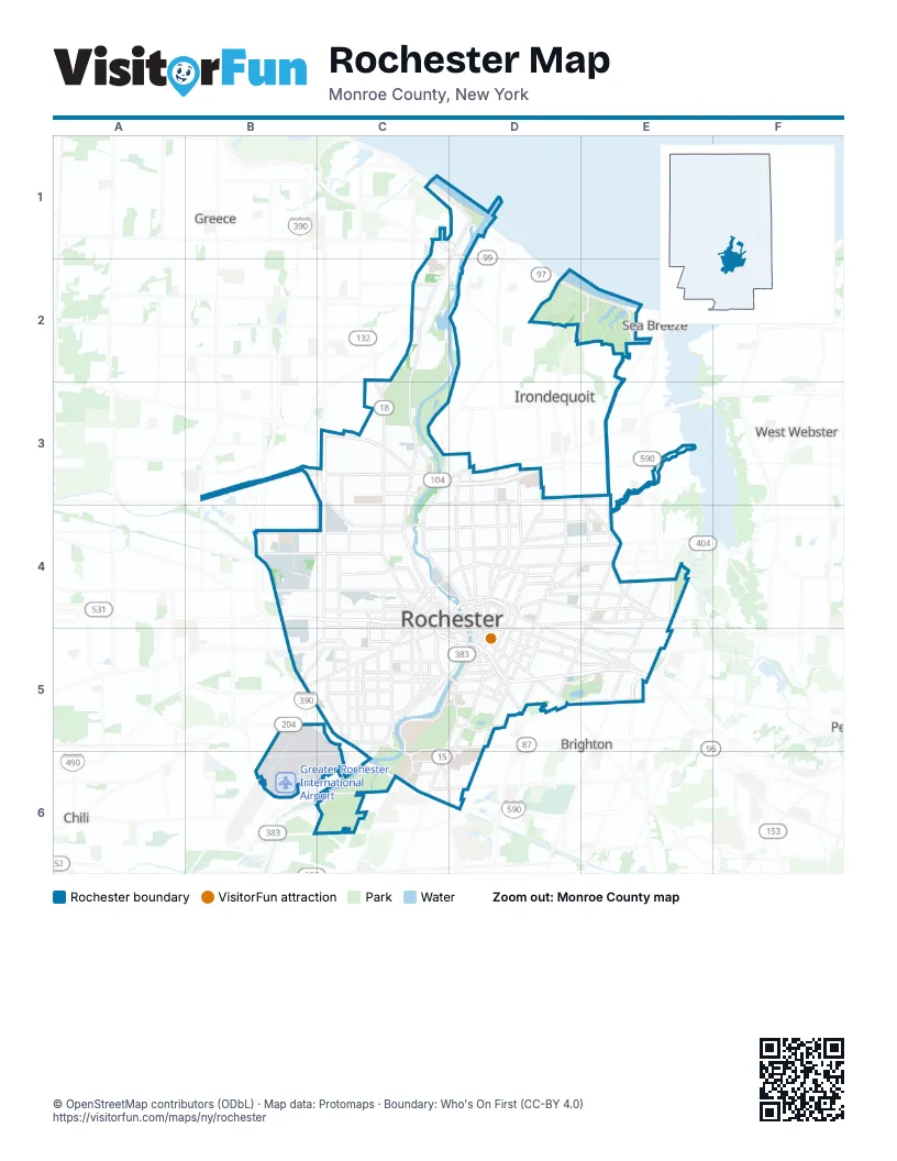
Street index of Rochester
Each street on the sheet and the grid squares it crosses.
- Beach AvenueC1, D1
- Lake Ontario State ParkwayC1, D1
- Latta RoadC1, D1
- Lake AvenueD1, C2, C3, C4
- Pattonwood DriveD1
- Saint Paul BoulevardD1, C3
- Bennington DriveC2, C3
- Britton RoadC2
- Denise RoadC2
- Stonewood AvenueC2
- Lake Shore BoulevardD2, E2
- North Kings HighwayD2, E2
- Culver RoadE2, E3, E4, D5, E5
- Durand BoulevardE2
- Sweet Fern RoadE2
- Outer LoopB3, E4, C5, E5, C6
- Ridgeway AvenueB3, C3
- Bridge View DriveC3
- Dewey AvenueC3, C4
- Driving Park AvenueC3, C4
- East Ridge RoadC3, D3, E3
- Eastman AvenueC3
- Keeler Street ExpresswayC3, D3
- La Grange AvenueC3, C4
- Maplewood DriveC3
- Mount Read BoulevardC3, C4, C5
- Norton StreetC3, D3, E3
- Saint Paul StreetC3, C4, D4
- Seneca ParkwayC3
- West Outer DriveC3
- West Ridge RoadC3
- Carter StreetD3, D4
- Hudson AvenueD3, D4
- Joseph AvenueD3, D4
- North Clinton AvenueD3, D4
- North Goodman StreetD3, D4, D5
- North StreetD3, D4
- Portland AvenueD3, D4
- Seneca AvenueD3
- Waring RoadD3, E4
- Emerson StreetB4, C4
- Lee RoadB4
- Lexington AvenueB4, C4
- Lyell AvenueB4, C4
- Western ExpresswayB4, C4, C5
- Allen StreetC4, D4
- Ames StreetC4, C5
- Avenue DC4, D4
- Avenue EC4
- Bausch Memorial BridgeC4
- Bausch StreetC4
- Bloss StreetC4
- Brown StreetC4, C5
- Campbell StreetC4
- Child StreetC4, C5
- Clifford AvenueC4, D4, E4
- Felix StreetC4
- Glide StreetC4, C5
- Grape StreetC4
- Inner LoopC4, D4
- Jay StreetC4
- King StreetC4, C5
- Maple StreetC4, C5
- Morrie Silver WayC4
- Norman StreetC4
- North Plymouth AvenueC4, D4, D5
- Otis StreetC4
- Platt StreetC4
- Saxton StreetC4, C5
- Smith StreetC4
- South Vincent StreetC4
- State StreetC4, D4
- Upper Falls BoulevardC4, D4
- West Broad StreetC4, C5, D5
- Wilder StreetC4
- Alexander StreetD4, D5
- Andrews StreetD4
- Atlantic AvenueD4, E4
- Bay StreetD4, E4
- BroadwayD4, D5
- Central AvenueD4
- Central ParkD4
- Chestnut StreetD4, D5
- Circle StreetD4
- Cleveland StreetD4
- Cumberland StreetD4
- Delevan StreetD4
- Draper StreetD4
- East AvenueD4, D5, E5
- East Main StreetD4, E4
- Exchange BoulevardD4, D5
- Ferndale CrescentD4
- Fernwood AvenueD4
- Franklin StreetD4
- Garson AvenueD4, E4
- Lyndhurst StreetD4
- Niagara StreetD4
- North Chestnut StreetD4
- North Union StreetD4
- North Water StreetD4
- Northland AvenueD4, E4
- Oxford StreetD4, D5
- Parsells AvenueD4, E4
- Pennsylvania AvenueD4
- Randolph StreetD4
- Scio StreetD4
- South AvenueD4, D5, C6, D6
- South Clinton AvenueD4, D5
- South Union StreetD4, D5
- University AvenueD4, D5, E5
- Webster AvenueD4, E4
- West Main StreetD4, C5
- Akron StreetE4
- Browncroft BoulevardE4
- Culver ParkwayE4
- Empire BoulevardE4
- Fernwood ParkE4
- Harwick RoadE4
- Humboldt StreetE4, E5
- Lyceum StreetE4
- Merchants RoadE4
- North Winton RoadE4, E5
- Shelford RoadE4
- Spencer RoadE4
- Wisconsin StreetE4
- Woodman ParkE4
- Wyand CrescentE4
- Brooks AvenueB5, C5
- Buell RoadB5
- Buffalo RoadB5, C5
- Cairn StreetB5, C5
- Chili AvenueB5, C5
- Aberdeen StreetC5
- Arnett BoulevardC5
- Bartlett StreetC5
- Boys Club PlaceC5
- Columbia AvenueC5
- Danforth StreetC5
- Doctor Samuel McCree WayC5
- Elmwood AvenueC5, D5, C6
- Exchange StreetC5, D5
- Flint StreetC5
- Forbes StreetC5
- Ford StreetC5, D5
- Frost AvenueC5
- Gardiner AvenueC5
- Genesee Park BoulevardC5
- Genesee StreetC5
- Jefferson AvenueC5
- Joseph C. Wilson BoulevardC5, D5, C6
- Lincoln AvenueC5
- Mount Hope AvenueC5, D5, C6
- Pioneer StreetC5
- Post AvenueC5
- Ravenwood AvenueC5
- Reynolds StreetC5
- Sawyer StreetC5
- Scottsville RoadC5, B6, C6
- Seward StreetC5
- South Plymouth AvenueC5, D5
- South Washington StreetC5, D5
- Thurston RoadC5
- Virginia AvenueC5
- Wellington AvenueC5
- West AvenueC5
- Woodbine AvenueC5
- Averill AvenueD5
- Berkeley StreetD5
- Brighton StreetD5
- Byron StreetD5
- Caroline StreetD5
- Court StreetD5
- East Broad StreetD5
- Eastern ExpresswayD5, E5
- Field StreetD5
- Gregory StreetD5
- Highland AvenueD5, E5
- Howell StreetD5
- Linden StreetD5
- Meigs StreetD5
- Monroe AvenueD5
- Norris DriveD5, E5
- Park AvenueD5, E5
- South Goodman StreetD5
- Spring StreetD5
- Woodbury BoulevardD5
- Blossom RoadE5
- East Highland DriveE5
- South Winton RoadE5
- Beahan RoadB6
- Crittenden BoulevardC6
- Crittenden RoadC6
- East Henrietta RoadC6, D6
- East River RoadC6
- Kendrick RoadC6
- Lattimore RoadC6
- West Henrietta RoadC6
- Westfall RoadC6, D6
Things to do on the Rochester map
Places on the map
- Abelard Reynolds School No. 42
- Alex Park
- All City High
- Aquinas Institute
- Austin Steward Plaza
- Avenue D Recreation Center
- Bausch & Lomb Riverside Park
- Beechwood
- Brown Square Park
- Browncroft
- Camp Eastman
- Canal Side Business Center
- Charlotte Post Office
- Charlotte Whitney Allen Library
- City of Rochester
- CityGate
- Civic Center Plaza
- Cobb's Hill Park
- Cobbs Hill
- College Town
- Corn Hill
- Crittenden Road Ball Diamonds
- Delta Sonic Car Wash
- Durand Eastman Golf Course
- Durand Eastman Park
- Durand Lake
- East End Garage
- East High School
- Eastman Lake
- Eastman Quadrangle
- Edgerton
- Edgerton Park
- Edison Tech High School
- EMMA
- Erie Harbor Apartments
- ESL Ballpark
- Fairfield Village
- Fernwood Park Apartments
Next to Rochester
- Brighton
- Chili
- Greece
- Irondequoit
- Sea Breeze
- West Webster
© OpenStreetMap contributors (ODbL) · Map data: Protomaps · Boundary: Who's On First (CC-BY 4.0)