

South Dakota map
Rapid City Metro Area map
The sheet's index lists 11 highways; I-90, SD 34 and US 14 cross the most grid squares. Things to do inside the boundary: 1880 Train, Badlands National Park and Bear Butte State Park. Also on it: Custer, Faith and Hill City.
Open the map (PDF, US Letter)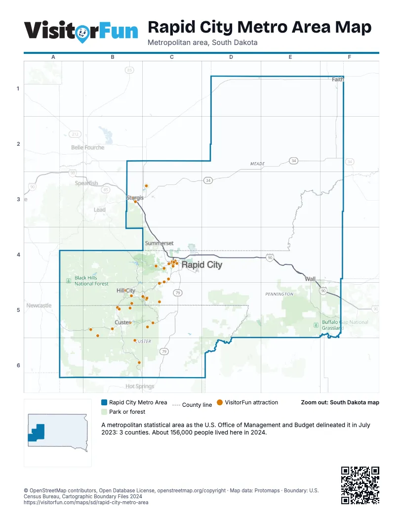
Highway index of Rapid City Metro Area
Each highway on the sheet and the grid squares it crosses.
- I-90B3, C3, C4, D4, E4, E5, F5
- I-190C4
- US 14B3, C3, C4, D4, E4
- US 14AB3
- US 16B5, C4, C5
- US 385B5
- SD 34B3, C3, D2, D3, E2, F2
- SD 40C5
- SD 44C4
- SD 73F2
- SD 79B3, C3, C4, C5, C6
Things to do on the Rapid City Metro Area map
- 1880 Train
- Badlands National Park
- Bear Butte State Park
- Bear Country USA
- Belle Joli Winery
- Big Thunder Gold Mine
- Black Elk Peak
- Black Hills Above & Beyond Tours
- Black Hills Aerial Adventures
- Black Hills Balloons
- Black Hills Bronco Adventures
- Black Hills Caverns
- Black Hills Glass Blowers
- Black Hills Helicopters
- Black Hills Wilderness Edge
- Chapel in the Hills
- Crazy Horse Memorial
- Custer State Park
- Custer State Park Resort
- Custer's Gulch RV Park and Campground
- Dinosaur Park
- Firehouse Brewing Company
- Flags & Wheels Indoor Racing
- Fort Meade
- Four Mile Old West Town Museum
- Gold Diggers Black Hills Gold
- Jewel Cave National Monument
- Keystone Historical Walking Tour
- Mount Rushmore Black Hills Gold
- Mount Rushmore Bookstores
- Mount Rushmore KOA Resort at Palmer Gulch
- Mount Rushmore National Memorial
- Museum at Black Hills Institute
- Museum of Geology
- National Presidential Wax Museum
- Needles Highway
- Old MacDonald's Farm
- Prairie Edge Galleries
- Putz n Glo
- Reptile Gardens
- Rush Mountain Adventure Park
- Rushmore Borglum Story
- Rushmore Tramway Adventures
- Signature Black Hills Tours
- Sioux Indian Museum
- Sprockets Fun Foundry
- Stagecoach West Tours
- Storybook Island
- Sturgis Car Museum
- Sturgis Motorcycle Museum & Hall of Fame
- Wall Drug Store
- Wind Cave National Park
- Wonderland Cave
Places on the map
- Custer
- Faith
- Hill City
- Rapid City
- Sturgis
- Summerset
- Wall
© OpenStreetMap contributors, Open Database License, openstreetmap.org/copyright · Map data: Protomaps · Boundary: U.S. Census Bureau, Cartographic Boundary Files 2024