

Indiana map
Indianapolis map
About 891,484 people live here (Census Bureau, 2024 estimate). The sheet's index lists 247 streets; Dwight D Eisenhower Highway, Lafayette Road and West 10th Street cross the most grid squares. Things to do inside the boundary: Benjamin Harrison Presidential Site, Eiteljorg Museum and Gainbridge Fieldhouse.
Open the map (PDF, US Letter)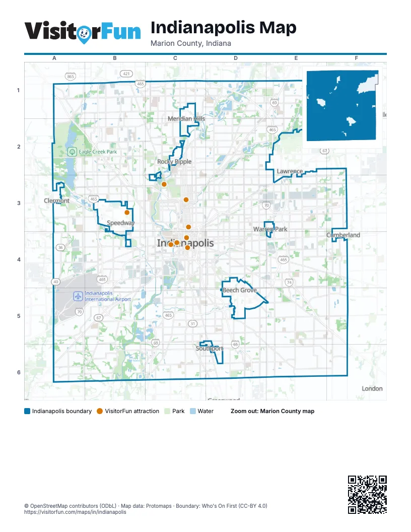
Street index of Indianapolis
Each street on the sheet and the grid squares it crosses.
- Lafayette RoadA1, A2, B2, B3, C3
- West 86th StreetA1, B1, C1
- Georgetown RoadB1, B2, B3
- Michigan RoadB1, B2, C2, C3
- West 79th StreetB1, C1
- West 96th StreetB1, C1
- Zionsville RoadB1, B2
- Ditch RoadC1, C2
- East 86th StreetC1, D1
- East 86th Street;West 86th StreetC1
- East 96th StreetC1, D1, E1, F1
- North College AvenueC1, C2, C3, C4
- North Meridian StreetC1, C2, C3, C4
- Township Line RoadC1, C2
- Westfield BoulevardC1, D1
- Allisonville RoadD1, D2
- Astronaut David Wolf BridgeD1
- Binford BoulevardD1, E1, D2
- Center Run DriveD1
- East 82nd StreetD1, E1
- I-465 WBD1, E1
- Keystone ParkwayD1
- North Keystone AvenueD1, D2, D3
- Fall Creek RoadE1, F1, D2, E2
- North Shadeland AvenueE1, E2, E3, E4
- Carroll RoadF1
- Fox RoadF1
- Sunnyside RoadF1
- Eagle Creek ParkwayA2, A3, B3
- East County Road 600 NorthA2
- Reed RoadA2
- West 46th StreetA2, C2
- West 56th StreetA2, B2
- West 71st StreetA2, B2
- Cooper RoadB2
- Kenneth "Babyface" Edmonds HighwayB2, B3, C3
- Kessler Boulevard North DriveB2, B3
- Kessler Boulevard West DriveB2, C2
- Westlane RoadB2, C2
- Central AvenueC2, C3
- East 46th StreetC2, D2, E2
- East 71st StreetC2, D2, E2
- East Westfield BoulevardC2
- Grandview DriveC2
- Kessler Boulevard East DriveC2, D2
- North Capitol AvenueC2, C3, C4
- West 73rd StreetC2
- West Westfield BoulevardC2
- East 56th StreetD2, E2
- East Fall Creek Parkway North DriveD2, C3, D3
- Emerson WayD2
- North Arlington AvenueD2, D3, D4
- North Emerson AvenueD2, D3, D4
- North Sherman DriveD2, D3, D4
- North Mitthoefer RoadE2, E3, E4
- North German Church RoadF2, F3, F4
- Country Club RoadA3, A4
- Crawfordsville RoadA3, B3
- Dandy TrailA3
- East County Road 200 NorthA3
- North Girls School RoadA3, A4
- North Raceway RoadA3, A4
- West 38th StreetA3, B3, C3
- Moller RoadB3
- North Concord StreetB3, B4
- North Holt RoadB3, B4
- Pike Plaza RoadB3
- West 10th StreetB3, C3, A4, B4, C4
- West 16th StreetB3, C3
- West 30th StreetB3, C3
- Bellefontaine StreetC3, C4
- Dr Andrew J Brown AvenueC3
- Dr Martin Luther King Jr StreetC3, C4
- Dr Martin Luther King StreetC3
- Dwight D Eisenhower HighwayC3, D3, E3, F3, B4, C4, A5, B5
- East 10th StreetC3, D3, E3, F3
- East 16th StreetC3, D3
- East 22nd StreetC3
- East 29th StreetC3
- East 30th StreetC3, D3, E3, F3
- East 34th StreetC3, D3, E3
- East 38th StreetC3, D3, E3, F3
- East Fall Creek Parkway, North DriveC3
- East Riverside DriveC3
- Fall Creek Parkway North DriveC3
- Indiana AvenueC3, C4
- Martindale AvenueC3
- North Alabama StreetC3, C4
- North Delaware StreetC3, C4
- North East StreetC3, C4
- North Illinois StreetC3, C4
- North Pennsylvania StreetC3, C4
- North Pershing AvenueC3
- North West StreetC3, C4
- North White River Parkway West DriveC3, C4
- Oscar Robertson BoulevardC3
- Sutherland AvenueC3
- West 11th StreetC3
- West 21st StreetC3
- West 22nd StreetC3
- West 29th StreetC3
- West Fall Creek Parkway North DriveC3
- West Fall Creek Parkway, North DriveC3
- Brookside Parkway South DriveD3
- Commerce AvenueD3
- East 21st StreetD3, E3, F3
- Massachusetts AvenueD3, E3, C4
- North Rural StreetD3, D4
- Nowland AvenueD3
- Accident Investigation SiteE3
- Franklin WayE3
- North Franklin RoadE3, E4
- North Mitthoeffer RoadE3
- North Post RoadE3, E4
- Pendleton PikeE3
- County Line RoadA4
- Rockville RoadA4, B4
- South Girls School RoadA4
- South Raceway RoadA4
- West Washington StreetA4, B4, C4
- Cossell RoadB4
- Holt RoadB4
- Maywood RoadB4, B5
- Michigan StreetB4
- North Lynhurst DriveB4
- Plainfield AvenueB4
- Sam Jones ExpresswayB4
- South Holt RoadB4, B5
- South Lynhurst DriveB4, B5
- South Tibbs AvenueB4
- Vandalia AvenueB4
- West Bradbury AvenueB4
- West Michigan StreetB4, C4
- West Morris StreetB4, C4
- West Raymond StreetB4, C4
- Westbrook AvenueB4
- Bluff RoadC4, C5, C6
- Calvary StreetC4
- Carson AvenueC4, C5, D5
- East Maryland StreetC4
- East McCarty StreetC4
- East Michigan StreetC4, D4
- East Morris StreetC4
- East New York StreetC4, D4
- East North StreetC4
- East Ohio StreetC4
- East Raymond StreetC4, D4, E4
- East Saint Clair StreetC4
- East South StreetC4
- East Washington StreetC4, D4, E4, F4
- English AvenueC4, D4
- Fletcher AvenueC4
- Kentucky AvenueC4, A5, B5, A6
- Madison AvenueC4, C5, D5, D6
- North Belmont AvenueC4
- North Davidson StreetC4
- North New Jersey StreetC4
- North Pine StreetC4
- Prospect StreetC4, D4
- Russell AvenueC4
- Shelby StreetC4, C5
- South Alabama StreetC4
- South Belmont AvenueC4
- South Capitol AvenueC4
- South College AvenueC4
- South Delaware StreetC4
- South East StreetC4, C5, C6
- South Harding StreetC4, C5
- South Illinois StreetC4
- South Meridian StreetC4, C5, C6
- South Missouri StreetC4
- South Pennsylvania StreetC4
- South Warman AvenueC4
- South West StreetC4
- South White River Parkway East DriveC4
- Southeastern AvenueC4, D4, F5
- West Maryland StreetC4
- West Mc Carty StreetC4
- West McCarty StreetC4
- West New York StreetC4
- West North StreetC4
- West Ohio StreetC4
- West Ray StreetC4
- West South StreetC4
- Brookville RoadD4, E4, F4
- Churchman AvenueD4
- East Pleasant Run Parkway North DriveD4
- East Pleasant Run Parkway South DriveD4
- Hoyt AvenueD4
- Leeds AvenueD4
- South Arlington AvenueD4, D5, D6
- South Emerson AvenueD4, D5, D6
- South Keystone AvenueD4, D5
- South Rural StreetD4
- South Sherman DriveD4, D5
- Davis RoadE4
- Shadeland AvenueE4
- South Franklin RoadE4, E5, E6
- South Mitthoefer RoadE4
- South Post RoadE4, E5
- South Shadeland AvenueE4
- Senour RoadF4, F5
- South German Church RoadF4
- Ameriplex ParkwayA5
- Colonel H. Weir Cook Memorial DriveA5
- Colonel H. Weir Cook Memorial Drive SouthA5
- Mann RoadB5, B6
- South High School RoadB5
- South Mooresville RoadB5, A6, B6
- West Mooresville RoadB5, A6
- West Thompson RoadB5, C5
- East Edgewood AvenueC5, D5, E5, F5
- East Hanna AvenueC5, D5
- East Thompson RoadC5, D5, E5, F5
- East Troy AvenueC5, D5
- Harding StreetC5
- Old State Road 37C5
- West Edgewood AvenueC5
- West Epler AvenueC5
- West Hanna AvenueC5
- West Troy AvenueC5
- Albany StreetD5
- EThompson RoadD5
- Gray RoadD5
- Shelbyville RoadD5, E6
- Sherman DriveD5
- Troy AvenueD5
- Acton RoadF5, F6
- Frontage RoadF5
- Camby RoadA6, B6
- Mooresville RoadB6
- West Southport RoadB6, C6
- County Road 300 WestC6
- East Southport RoadC6, D6, E6, F6
- East Stop 11 RoadC6, D6, E6
- Meridian School RoadC6
- Morgantown RoadC6
- North Morgantown RoadC6
- West County Line RoadC6, D6
- West County Line Road SouthC6
- West Meridian School RoadC6
- West Stop 11 RoadC6
- East County Line RoadD6
- East County Line Road SouthD6, E6
- Frye RoadE6
- Mathews RoadE6
- Maze RoadE6, F6
Things to do on the Indianapolis map
Places on the map
- 7 Pointe Apartments
- 82nd Flats at the Crossing
- Abbington
- Abby Road
- Adler Grove
- Admiral's Point
- Allison Ponte
- American Village
- Arlington Meadows
- Arrowhead at Southern Dunes
- Arsenal Heights
- Arsenal Technical High School
- Ascension St. Vincent Hospital - Indianapolis
- Ashland
- Ashland Pointe
- Assurance Health Psychiatric Hospital
- Autumn Creek
- Autumn Creek East
- Avalon Crossing
- Avalon Estates
- Avalon Hills
- Avery Point
- Bates-Hendricks
- Bayshore Villas
- Bayside Woods
- Beam Reach
- Bean Creek
- Beaumont on the Green
- Belmoore
- Ben Davis Park
- Bently Commons
- Bently Farms
- Bethel Creek
- Big Run
- Birchwood Park
- Blackburn Terrace
- Blickman Trail Park
- Bolander Woods
- Bosart-Brown
- Bottleworks District
Next to Indianapolis
- Beech Grove
- Clermont
- Cumberland
- Lawrence
- London
- McCordsville
- Meridian Hills
- Rocky Ripple
- Speedway
- Warren Park
© OpenStreetMap contributors (ODbL) · Map data: Protomaps · Boundary: Who's On First (CC-BY 4.0)