

North Carolina map
Asheville & the Foothills map
The sheet's index lists 26 highways; US 64, US 74 and I-40 cross the most grid squares. Things to do inside the boundary: Asheville Art Museum, Biltmore Estate and Black Mountain College Museum + Arts Center. Also on it: Asheville, Brevard and Columbus.
Open the map (PDF, US Letter)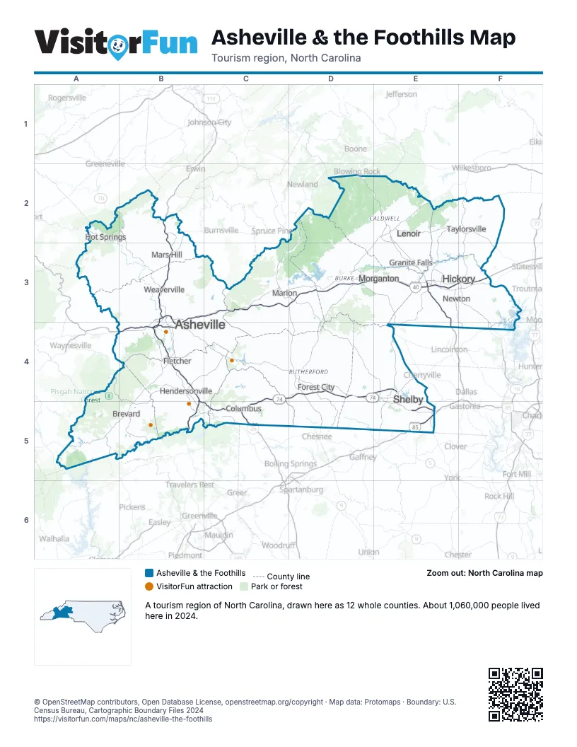
Highway index of Asheville & the Foothills
Each highway on the sheet and the grid squares it crosses.
- I-26B2, B3, B4, B5, C5
- I-40B3, B4, C3, D3, E3, F3
- I-85E5
- I-240B3, B4
- US 19B2, B3
- US 23B2, B3
- US 25B2, B3, B4, B5
- US 29E5
- US 64A5, B4, B5, D4, E2, F2, F3
- US 70B2, B3, C3, E3, F3
- US 74B4, B5, C4, C5, D4, E4, E5
- US 74AB3, B4, D4
- US 221C3, D2, D3, D4, D5
- US 276B5
- US 321D2, E2, E3, E4
- NC 16F2, F3, F4
- NC 18E2
- NC 90E2, F2
- NC 150E4
- NC 191B4
- NC 208A2, B2
- NC 213B3
- NC 226C3, D3, E4, E5
- NC 280B4, B5
- NC 281A5
- SR 9000D4, E4
Things to do on the Asheville & the Foothills map
- Asheville Art Museum
- Biltmore Estate
- Black Mountain College Museum + Arts Center
- Blue Ridge Parkway
- Carl Sandburg Home National Historic Site
- Chimney Rock at Chimney Rock State Park
- DuPont State Recreational Forest
- Folk Art Center
- Gorges State Park
- Kings Mountain Historical Museum
- Lake James State Park
- Linville Caverns
- North Carolina Arboretum
- South Mountains State Park
- Valley Hills Mall
Places on the map
- Asheville
- Brevard
- Columbus
- Fletcher
- Forest City
- Granite Falls
- Hendersonville
- Hickory
- Hot Springs
- Lenoir
- Marion
- Mars Hill
- Morganton
- Newton
- Shelby
- Taylorsville
- Weaverville
Next to Asheville & the Foothills
- Charlotte Region map
- High Country map
- Smoky Mountains & Cherokee map
- Lake Hartwell Country
- Olde English District
- The Upcountry
- East Tennessee
© OpenStreetMap contributors, Open Database License, openstreetmap.org/copyright · Map data: Protomaps · Boundary: U.S. Census Bureau, Cartographic Boundary Files 2024