

Nevada map
Las Vegas-Henderson-North Las Vegas Metro Area map
The sheet's index lists 13 highways; US 95, I-15 and US 93 cross the most grid squares. Things to do inside the boundary: 5 Star Helicopter Tours, Adventuredome and Allegiant Stadium. Also on it: Henderson, Las Vegas and Mesquite.
Open the map (PDF, US Letter)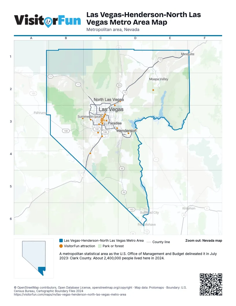
Highway index of Las Vegas-Henderson-North Las Vegas Metro Area
Each highway on the sheet and the grid squares it crosses.
- I-11C2, C3, D3
- I-15C3, C4, D1, D2, E1, F1
- I-215C3
- US 93C3, D1, D2, D3
- US 95A2, B2, C2, C3, D3, D4, D5, D6
- FR 8D2
- SR 146C3
- SR 160B3, C3
- SR 163D6
- SR 173D3
- CC 215C2, C3
- SR 564C3
- SR 613C3
Things to do on the Las Vegas-Henderson-North Las Vegas Metro Area map
- 5 Star Helicopter Tours
- Adventuredome
- Allegiant Stadium
- Ameri-Trip
- AREA15
- Aria Resort & Casino
- Atomic Museum
- Bacchanal Buffet at Caesars Palace
- Battlefield Vegas
- Bellagio
- Binion's Gambling Hall
- Bistecca Italian Steakhouse
- Blazin Paddles
- Blue Man Group at Luxor
- Caesars Palace
- Caffè Bottega
- Circa Resort & Casino
- Circus Circus Las Vegas
- Cirque du Soleil: O
- Comedy on Deck Tours
- Dig This
- Dirt Dog
- Donkey History Museum
- Downtown Container Park
- Durango Casino & Resort
- Eiffel Tower Viewing Deck at Paris Las Vegas
- Encore Las Vegas
- Escape Adventures
- Excalibur Hotel and Casino
- Fashion Show Las Vegas
- Flamingo Las Vegas
- Fontainebleau Las Vegas
- Fountains of Bellagio
- Four Queens
- Fremont Hotel & Casino
- Fremont Street Experience
- Galleria at Sunset
- Giordano's
- Gold & Silver Pawn Shop
- Golden Gate Hotel & Casino
- Golden Nugget Las Vegas
- Grand Canal Shoppes
- Green Valley Ranch Resort
- Harrah's Las Vegas
- High Roller Observation Wheel
- Hollywood Cars Museum
- Hoover Dam
- Hoover Dam Lodge
- Horseshoe Las Vegas
- Hypnosis Unleashed
- iSmash Las Vegas
- Jerry's Nugget
- Lake Mead Cruises
- Lake Mead National Recreation Area
- Las Vegas Boat Harbor
- Las Vegas Distillery
- Las Vegas Guided Tours
- Las Vegas Motor Speedway
- Las Vegas North Premium Outlets
- Las Vegas Outdoor Adventures
- Las Vegas Outdoor Fun
- Las Vegas South Premium Outlets
- Las Vegas Strip
- Luxor Las Vegas
- M Resort Spa Casino
- Madame Tussauds Las Vegas
- Mandalay Bay
- Marilyn's Cafe
- Maverick Helicopters
- Metro Pizza
- MGM Grand
- Mike O'Callaghan–Pat Tillman Memorial Bridge
- Miracle Mile Shops
- New York-New York Hotel & Casino
- Nostalgia Street Rods
- Palace Station
- Palms Casino Resort
- Paris Las Vegas
- Park MGM
- Piff the Magic Dragon
- Pinball Hall of Fame
- Pink Jeep Tours Las Vegas
- Planet Hollywood Las Vegas
- PUB 365
- Red Rock Canyon National Conservation Area
- Red Rock Casino Resort & Spa
- Resorts World Las Vegas
- Rio Hotel & Casino
- Rouge
- Sahara Las Vegas
- Seven Magic Mountains
- Shark Reef Aquarium at Mandalay Bay
- Silverton Casino Hotel
- Skydive Las Vegas
- South Point Hotel, Casino & Spa
- Sphere
- Springs Preserve
- Spy Ninjas HQ
- T-Mobile Arena
- The Boulevard Mall
- The Cosmopolitan of Las Vegas
- The D Las Vegas
- The Forum Shops at Caesars
- The LINQ Hotel + Experience
- The Mob Museum
- The Neon Museum
- The Orleans Hotel & Casino
- The Platinum Hotel & Spa
- The Rat Pack Is Back
- The Shops at Crystals
- The STRAT
- The Venetian Gondola Rides
- The Venetian Resort Las Vegas
- Town Square Las Vegas
- Treasure Island Las Vegas
- Universal Horror Unleashed
- Valley of Fire State Park
- Vegas Specialty Tours
- Village Pub & Cafe
- Virgin Hotels Las Vegas
- Wahlburgers
- Welcome to Fabulous Las Vegas Sign
- WOW - The Vegas Spectacular
- Wynn Las Vegas
Places on the map
- Henderson
- Las Vegas
- Mesquite
- Moapa Valley
- North Las Vegas
- Paradise
- Summerlin South
© OpenStreetMap contributors, Open Database License, openstreetmap.org/copyright · Map data: Protomaps · Boundary: U.S. Census Bureau, Cartographic Boundary Files 2024