

New York map
Nassau County map
A printable two-page map of Nassau County (Long Island, New York), drawn by VisitorFun from OpenStreetMap. Page two is the street index: every street on the sheet with its grid square, the same list as below.
Open the map (PDF, US Letter)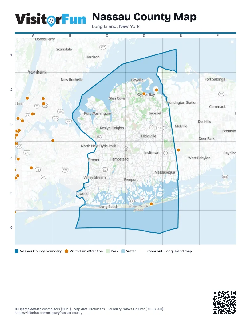
Street index of Nassau County
Each street on the sheet and the grid squares it crosses.
- Grand Central ParkwayC3
- Long Island ExpresswayC3, D3, E3
- Northern State ParkwayC3, D3, E3
- Seaford-Oyster Bay ExpresswayD3, D4, E4, D5
- Wantagh State ParkwayD3, D4, D5
- Belt ParkwayB4, C4
- Cross Island ParkwayB4, C4
- Southern State ParkwayB4, C4, D4, E4
- Meadowbrook State ParkwayC4, D4, D5
- Loop ParkwayD5
Things to do on the Nassau County map
Places on the map
- Albertson
- Baldwin
- Baldwin Harbor
- Baldwin Park
- Bar Beach
- Barnum Island
- Baxter Estates
- Bay Park
- Beach Haven
- Beacon Hill
- Beaver Lake
- Bellerose Terrace
- Bellmore
- Belmont Park
- Bethpage
- Bethpage State Park Golf Courses
- Birchwood at Jericho
- Bowling Green Estates
- Broadway Mall
- Brookfield Estates, Section 1
- Brookville Colonial Gardens
- Brookville Country Club
- Brookville Meadows
- Cantiague Park
- Carle Place
- Cathedral Gardens
- Cedar Creek Park
- Cedar Swamp Creek
- Centre Island Beach
- Centre Island Estuary
- Cherry Valley Golf Course
- Christopher Morley Park
- City of Glen Cove
- City of Long Beach
- Clearview Village
- Country Estates at East Hills
- Country Estates at Flower Hill
- Country Pointe at Plainview
- Creek Club
- Crossways Park
Maps inside Nassau County
Next to Nassau County
- Bay Shore
- Brentwood
- Centerport
- Commack
- Deer Park
- Dix Hills
- Dobbs Ferry
- East Northport
- Englewood
- Fort Lee
- Fort Salonga
- Greenlawn
- Harrison
- Huntington Station
- Melville
- Mount Vernon map
- New Rochelle map
- North Amityville
- Port Chester
- Rye
- Scarsdale
- South Huntington
- Tuckahoe
- West Babylon
- West Islip
- Wyandanch
- Yonkers map
© OpenStreetMap contributors (ODbL) · Map data: Protomaps · Boundary: Who's On First (CC-BY 4.0)