

Ohio road map
Lake Erie Coastal Ohio Trail map
The Lake Erie Coastal Ohio Trail has been a National Scenic Byway since 2005, named for its historic qualities: about 292 miles in Ohio. It meets 47 highways, among them I-75, I-80 and I-90. Towns along it: Cleveland, Toledo and Lorain.
Open the map (PDF, US Letter)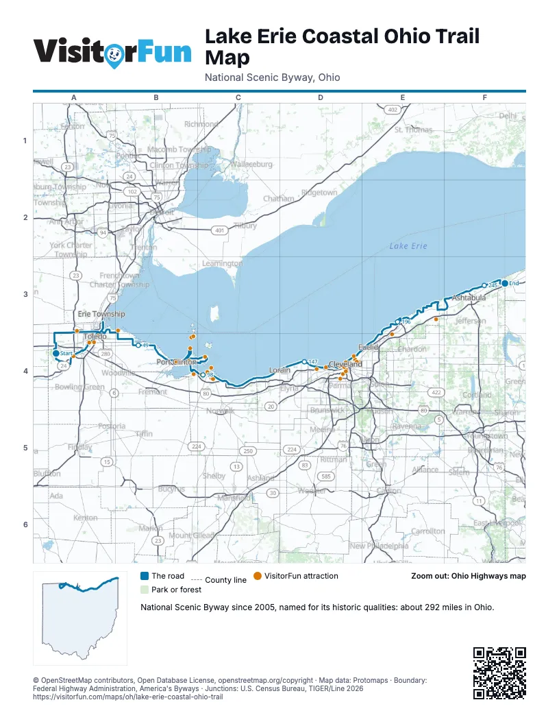
Highways it meets
Each highway it meets and the grid squares where they meet.
- OH 295A4
- OH 64A4
- US 24A4
- I-475A4
- US 23A4
- US 20A4
- OH 25A4
- I-90A4
- I-80A4
- I-75A4
- OH 2A4
- OH 51A4
- OH 65A4
- OH 120A4
- I-280A4
- OH 590B4
- OH 19B4
- OH 358B4
- OH 163B4
- OH 53B4
- OH 269B4
- US 6C4
- OH 4C4
- OH 61C4
- OH 60C4
- OH 611C4
- OH 58C4
- OH 57C4
- OH 301D4
- OH 83D4
- OH 252D4
- OH 113D4
- OH 237D4
- OH 283D4
- OH 175E4
- OH 640E4
- OH 91E4
- OH 306E3
- OH 44E3
- OH 535E3
- OH 534F3
- OH 531F3
- OH 45F3
- OH 11F3
- OH 46F3
- OH 193F3
- OH 7F3
Towns along the Lake Erie Coastal Ohio Trail
In mile order, with the grid square of each.
- Whitehousemile 3, A4
- Watervillemile 6, A4
- Perrysburgmile 10, A4
- Maumeemile 11, A4
- Toledomile 17, A4
- Rossfordmile 21, A4
- Oregonmile 29, A3
- Curticemile 39, B4
- Port Clintonmile 67, B4
- Lakesidemile 80, C4
- Marbleheadmile 81, C4
- Sanduskymile 96, C4
- Huronmile 108, C4
- Mitiwangamile 116, C4
- Beulah Beachmile 118, C4
- Vermilionmile 122, C4
- Lorainmile 128, C4
- Amherstmile 129, C4
- Sheffieldmile 138, D4
- Sheffield Lakemile 139, D4
- Avon Lakemile 142, D4
- Bay Villagemile 149, D4
- Westlakemile 151, D4
- Rocky Rivermile 155, D4
- Lakewoodmile 157, D4
- Clevelandmile 160, D4
- Bratenahlmile 171, D4
- East Clevelandmile 173, D4
- Euclidmile 177, E4
- Wickliffemile 181, E4
- Willowickmile 182, E4
- Eastlakemile 184, E4
- Lakelinemile 185, E4
- Timberlakemile 186, E4
- Willoughbymile 187, E4
- Mentormile 190, E3
- Mentor-on-the-Lakemile 191, E3
- Grand Rivermile 197, E3
- Fairport Harbormile 199, E3
- Painesvillemile 199, E3
- Perrymile 206, E3
- North Perrymile 208, E3
- North Madisonmile 212, E3
- Genevamile 222, F3
- Geneva-on-the-Lakemile 227, F3
- Saybrook-on-the-Lakemile 230, F3
- Ashtabulamile 234, F3
- North Kingsvillemile 242, F3
- Conneautmile 247, F3
- Ottawa Hillsmile 271, A3
- Sylvaniamile 277, A3
Things to do on the Lake Erie Coastal Ohio Trail map
- Fallen Timbers Battlefield and Fort Miamis National Historic Site
- Wildwood Preserve Metropark
- Toledo Zoo & Aquarium
- Hollywood Casino Toledo
- Imagination Station
- National Museum of the Great Lakes
- Jet Express
- Fast Eddie's Sports Park - Bar & Kitchen
- Portage River Paddling Company
- African Safari Wildlife Park
- Miller Ferry
- Kelleys Island Ferry Boat Line
- Toft's Dairy Ice Cream Parlor
- Cameo Pizza
- Merry-Go-Round Museum
- The Marketplace Downtown
- Goofy Golf
- Dave & Buster's Westlake - Cleveland
- Beachcliff Market Square
- Edgewater Park
- Great Lakes Brewing Company
- West Side Market
- Greater Cleveland Aquarium
- JACK Cleveland Casino
- Lady Caroline Cruises
- The Funny Bus Cleveland
- Cleveland Mall
- The Arcade Cleveland
- Great Lakes Science Center
- Rock & Roll Hall of Fame
- Goodtime III Sightseeing Cruise
- USS Cod Submarine Memorial
- Playhouse Square
- Cleveland Lakefront Nature Preserve
© OpenStreetMap contributors, Open Database License, openstreetmap.org/copyright · Map data: Protomaps · Boundary: Federal Highway Administration, America's Byways · Junctions: U.S. Census Bureau, TIGER/Line 2026