

Oklahoma map
Osage County map
About 46,495 people live here (Census Bureau, 2024 estimate). The sheet's index lists 300 streets; 1st Street, 2nd Street and 3rd Street cross the most grid squares. Things to do inside the boundary: Bartlesville, Gilcrease Museum and Osage Casino Hotel - Skiatook.
Open the map (PDF, US Letter)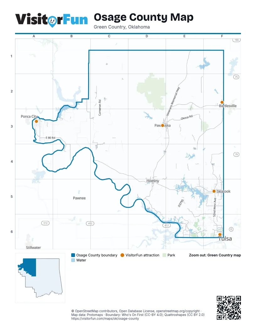
Street index of Osage County
Each street on the sheet and the grid squares it crosses.
- Keystone ExpresswayE6
- L. L. Tisdale ParkwayF6
- Veterans Memorial HighwayE1, E2, E3, D4, D5
- Bartlesville RoadE2, F2
- East Main StreetD3, E3, E4, D5
- West Main StreetD3, E4, D5
- East Harding RoadA3
- Western DriveF2, F5
- WesternF2
- Southwest Adams BoulevardF2
- Major General Clarence L. Tinker Memorial HighwayC4, D4, D5, E5, F5
- Frank Phillips Memorial HighwayF2, E3, F3, E4
- 1st StreetC2, C3, D3, C4, D4, E4, F4, D5, E6
- West W.C. Rogers BoulevardF5
- Main StreetC1, C3, C4, D4, F4, D5, E6
- Sergeant Bucky Eisenberger Memorial HighwayE3, D4, E4
- West Edison Street NorthF6
- West 36th Street NorthF6
- 5th StreetC2, D3, D4, E4, D5
- North Eastern AvenueD4, D5
- West 1st StreetD4, D5, F5
- Cosden AvenueC2
- South Main StreetC4
- South Eastern AvenueD5
- East 1st StreetD3, D5
- Anita Bryant AvenueE4
- East Apache StreetF6
- Antwine AvenueD4
- North Main StreetC4
- BroadwayC1
- Spruce AvenueE4
- East Coleman RoadB2
- East W.C. Rogers BoulevardF5
- T. N. Barnsdall Memorial BridgeE4
- Okesa RoadE3
- North 52nd West AvenueF5, F6
- Rock School RoadE5, F5, E6, F6
- Lake RoadF5
- North Javine Hill RoadF4, F5
- Shell Creek RoadE6, F6
- New Prue RoadD5, E6
- Apperson RoadB2, B3
- East 80 RoadA3, B3
- Glasgow RoadA3
- Denoya RoadC2, A3
- North Osage DriveF5, F6
- West Oak StreetD5, F5
- Old River RoadA3
- County Road 3551E2
- Prue RoadD5
- North 41st West AvenueF6
- County Road 2300F4
- Wulf RoadB3, B4
- Lombard LaneF4, F5
- D3795 RoadE5
- Lynn AvenueD3, E3
- South Lombard LaneF5
- Ranchland RoadE4, E5
- 3rd StreetC1, C2, C3, D3, D4, E4, F4, D5
- Country Club RoadC3, C4, D4
- Country Road 6301B4
- Old State Highway 11F4
- North Lombard LaneF5
- D3790E5
- Osage Hills Park RoadE2, E3
- West 103rd Street NorthF5
- North 53rd West AvenueF6
- 43rd Street NorthF6
- 14 Mile RoadB3, B4
- County Road 2561E3
- Fairfax Lake RoadC3
- Country Road 2431E3
- County Road 2130D4, E4, D5
- City View RoadA3
- Anderson RoadE6
- West Country RoadF5
- D0516 RoadE5
- 209 West AvenueE6
- D3815 RoadE4
- Grandview AvenueD3
- D0410 RoadD4, D5
- 11 Mile RoadB3
- Lynn RoadD3, E3
- Old Towne RoadE6
- Kaw Dam RoadB3
- Gilcrease ExpresswayF6
- Sunset BoulevardF2
- North 177th West AvenueE6
- West Apache StreetF6
- Osage AvenueF4, F6
- Kelly AvenueA3
- N3780 RoadE4
- East Evergreen StreetD3, E3
- North Lennapah StreetF5
- 129th Avenue WestE6, F6
- Grand AvenueC2, F4, D5
- South Osage StreetE1, F5
- Country RoadF5, E6, F6
- West Newton StreetF6
- Airport RoadE6
- East 100 RoadB4
- North Union Avenue WestF6
- East 15th StreetD3, E3
- West Tina TrailE6
- North Booker AvenueD4, D5
- East 10th StreetD3, E3, D5
- West Pine Street NorthF6
- Saint Paul AvenueE3
- Kelley AvenueA3
- Broadway AvenueF4, E6
- North 209th West AvenueE6
- South AvenueE1, B3, C3
- Stallard RoadD4
- Cotton Gin RoadD5
- County Road 2230E4
- Dildine RoadD5
- East West 028C3
- South 8th StreetC4
- North Gilcrease Museum RoadF6
- N3930 RoadF3
- Mayfield RoadE6
- West 31st Street NorthF6
- Big Snake RoadA3
- North 57th West AvenueF6
- 170th Street NorthF5
- Kihekah AvenueD3
- McCarkle AvenueC3
- West Elm AvenueC4
- North Dotson DriveE6
- 57th West AvenueF5, F6
- West 133rd StreetF5
- Brennan AvenueF4
- County Road 3235F2
- Javine Hill RoadF4
- North Union AvenueF6
- N3660 RoadD5
- Cherry StreetC2, E3, F5
- West 10th StreetD3, D5
- North Javine HillF5
- Ash StreetC2
- West Fairview Street NorthF6
- Mason BoulevardC4
- South Haines AvenueD5
- West Chestnut AvenueE4
- Miller DriveE6
- 176th Street NorthF5
- North 209 West AvenueE6
- CR 2145F3
- ApacheF6
- Gap RoadF3
- North 8th StreetC4
- County Road 3022F2
- West Taft AvenueC4
- South Freeman AvenueD5
- East Taft AvenueC4
- West 136th Street NorthF5
- Willow StreetE6
- Oak Park RoadF2
- South Booker AvenueD5
- East Oak StreetD5, F5
- 80 RoadA3, B3
- South 52nd West AvenueF5
- South Santa Fe StreetE1
- Old Highway 60C3
- West 14th StreetF2
- 4 Mile RoadF2
- West 2600 RoadF3
- 3940 RoadF3
- Larchmont DriveF2
- North Sand Springs Road WestF6
- Doga Creek RoadB3, B4
- Zink Ranch RoadE5, E6
- Remington RoadC3
- CR 5101D3
- Cameron RoadC2, C3
- D3573 RoadC2, C3
- West 53rd Street NorthF6
- West Overlook DriveE6, F6
- Burbank Landing RoadB2, B3
- Sarge Creek RoadB2, C2
- Joe Colby RoadA3, B3
- 9 Mile RoadB3
- Arrow RoadD1, E1
- East Hunt RoadA3
- Bill Morris RoadC3, C4
- 113th St. N.F5
- Possum Hollar RoadB3
- Woolaroc Ranch RoadF3
- 2nd StreetB2, C2, C3, D3, D4, E4, F4, D5, E6
- East 90 RoadA3
- North 68th West AvenueF5, F6
- Lazy LaneB3
- West 88th Street NorthF5
- Skyline DriveD3, E3
- Round Mound RoadB3, B4, C4
- Peach Orchard RoadE5, E6
- Braden School RoadA3, B3
- Fair Fax LaneC3
- McCord RoadA3
- Creek RoadF5, E6
- D3728 RoadD5
- Old Highway 11E3
- 68th West AvenueF5
- Pular DriveE6
- 6th StreetC1, C2, C3, D4, E4, D5
- Old State Highway 18C3
- North Wild Mountain RoadF6
- Little Chief RoadC3
- North 36th West AvenueF5
- 8 Mile RoadA3
- N3505 RoadB2
- Wilson RoadE6
- Tall Chief CoveE5, F5
- Tate RoadC4
- County Road 6102A4
- North 24th West AvenueF6
- Middle Doga Creek RoadB3, B4
- 20th West AvenueF5
- County Road 6495A4
- South George BradenB3
- 36th West AvenueF5, F6
- North 68 West AvenueF5
- 133rd Street NorthF5
- Creek 4551C1
- 7th StreetC1, C2, C3, D4, E4
- Little Doga RoadB3
- Sullins RoadC3, C4
- Whizbank RoadC2, C3
- CreekE5, F5, E6
- 7 Mile RoadA3
- Ecker LaneF6
- North 33rd Avenue WestF6
- West 93rd Street NorthF5
- West 4th StreetF2, D5, F5
- East Tower RoadB2
- Wooten RoadB3
- 4th StreetC2, D3, D4, E4
- C R 5902D3
- W.C. Rogers BoulevardF5
- County Road 2511E3
- North 100th WestF5, F6
- Country Road 2200F4
- North 25th West AvenueF5, F6
- Crystal Bay DriveE5
- Alice DriveF4
- West 6th StreetD3, D5, F5
- Pawnee RoadE6
- South 5 Mile RoadA3
- Osage StreetC2, C3, C4, D4, E4, E6
- Holt RoadE5
- North Choctaw RoadF5
- Panther Lake Ranch RoadD3, D4
- West 63rd Street NorthE6, F6
- Keeler RoadB3
- East George Braden RoadB3
- West 5th StreetD3, D5, F5
- East 8th StreetD3, E3, D5
- West Maple AvenueC4, E4, F5
- North Waco AvenueF6
- Sunset Ridge RoadD5, D6
- George Braden RoadA3, B3
- Indian Springs RoadA3
- Graham RoadB2
- Hunt RoadA3
- WhizbankC2, C3
- East 13th StreetD3, E3, D5
- Chickasaw RoadE6
- Boy Scout LoopE5
- East 70 RoadA3, B3
- South Osage Cove RoadB3
- Northside Lake RoadD3
- 84th West AvenueF5
- Tee Pee RoadD5
- E0190 RoadF3
- West 68th PlaceF5
- Wells DriveF5
- Lake DriveE6
- L B May DriveD3
- Old Bartlesville RoadE2
- 50th StreetF5
- Broadway StreetC2, D5
- West 193 StreetF4
- North 116 Street West AvenueE5, F5
- Phillips RoadF4
- Osage Cove RoadB3
- N3710 RoadD5
- West Bay Shore DriveE6
- Scenic CircleE5
- Windycrest RoadE6
- Country Road 2580E3
- South Regan AvenueD5
- Terrace DriveE6
- East 9th StreetD3, E3, D5
- South Indian Hills RoadA3
- Skylar LaneE4
- North Xenophon AvenueF6
- Country Road 1625D5, E5
- Pearsonia RoadD2
- 31st West AvenueF5
- Palmer AvenueD3
Things to do on the Osage County map
Places on the map
- American Environmental Landfill
- Avant
- Bar-Dew Lake
- Barnsdall
- Bartlesville
- Bartlesville Municipal Airport
- Birch Reservoir
- Black Dog Park
- Bluestem Lake
- Burbank
- Fairfax
- Foraker
- Grainola
- Hominy Municipal Lake
- Hominy;𐒹𐓘́͘𐓨𐓘͘𐓵𐓣͘
- Hudson Lake
- Hulah Lake
- Joseph H. Williams Tallgrass Prairie Preserve
- Keystone Lake
- McCord
- Oknoname 113004 Reservoir
- Osage
- Osage Hills State Park
- Pawhuska;𐓄𐓘𐓢𐓶𐓮𐓤𐓘
- POSTOAK Lodge & Retreat
- Prue
- Red Trail
- Shell Lake
- Shidler
- Skiatook
- Skiatook Lake
- Tall Chief Cove
- The Lodge at Taylor Ranch
- Tulsa Botanic Garden
- Twin Points
- Waxhoma Lake
- Webb City
- Woolaroc Wildlife Preserve
- Wynona
- Zink Ranch
Next to Osage County
© OpenStreetMap contributors, Open Database License, openstreetmap.org/copyright · Map data: Protomaps · Boundary: Who's On First (CC-BY 4.0); Quattroshapes (CC BY 2.0)















