

Pennsylvania map
Philadelphia map
About 1,573,916 people live here (Census Bureau, 2024 estimate). The sheet's index lists 260 streets; Delaware Expressway, Roosevelt Boulevard and Frankford Avenue cross the most grid squares. Things to do inside the boundary: Barnes Foundation, Best Western Plus Philadelphia Convention Center Hotel and Betsy Ross House.
Open the map (PDF, US Letter)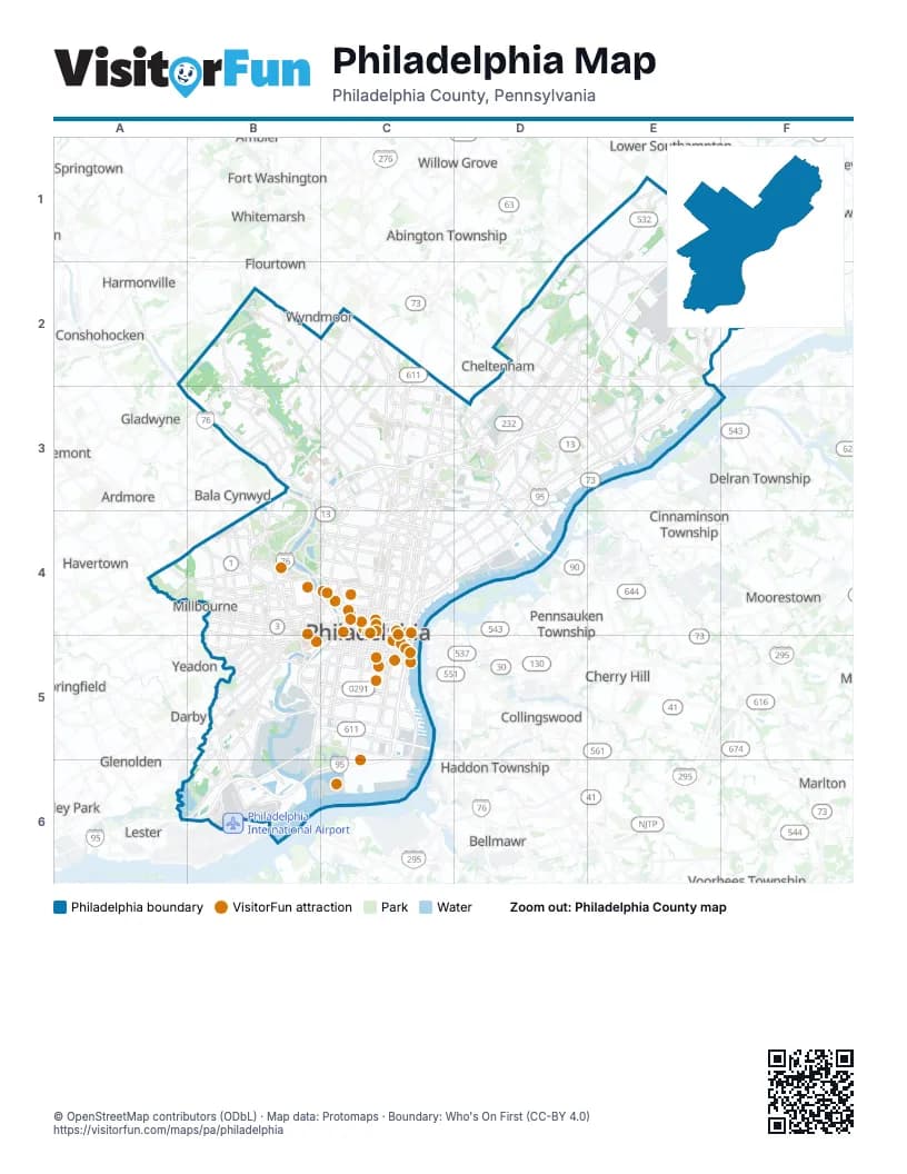
Street index of Philadelphia
Each street on the sheet and the grid squares it crosses.
- Red Lion RoadD1, E1, E2
- Welsh RoadD1, D2, E2
- Bustleton AvenueE1, D2, E2, D3
- Bustleton PikeE1
- Byberry RoadE1
- County Line RoadE1
- Evans StreetE1
- Lincoln HighwayE1
- Philmont AvenueE1
- Roosevelt BoulevardE1, D2, E2, C3, D3
- Verree RoadE1, D2, E2
- Woodhaven RoadE1, E2, F2
- Bethlehem PikeB2
- Cresheim Valley DriveB2
- East Mermaid LaneB2
- East Mount Airy AvenueB2, C2
- Emlen StreetB2, B3
- Germantown AvenueB2, C2, C3
- Henry AvenueB2, B3, C3
- Lincoln DriveB2, B3, C3
- Paper Mill RoadB2
- Ridge AvenueB2, B3, C3, C4
- Stenton AvenueB2, C2, C3
- West Allens LaneB2
- Cheltenham AvenueC2, C3
- East Washington LaneC2, C3
- Easton RoadC2
- North Broad StreetC2, C3, C4
- Ogontz AvenueC2, C3
- Old York RoadC2
- South Easton RoadC2
- Wadsworth AvenueC2
- Washington LaneC2
- West Cheltenham AvenueC2
- Castor AvenueD2, D3, D4
- Central AvenueD2
- Cottman AvenueD2, D3, E3
- Hasbrook AvenueD2
- Oxford AvenueD2, D3
- Rhawn StreetD2, E3
- Rising Sun AvenueD2, C3, D3
- Academy RoadE2, F2, E3
- Bristol PikeE2
- Delaware ExpresswayE2, D3, E3, C4, D4, C5, B6, C6
- Frankford AvenueE2, D3, E3, C4, D4
- Grant AvenueE2
- Haldeman AvenueE2
- Holme AvenueE2
- Knights RoadE2, F2
- Mill RoadE2
- Northeast BoulevardE2
- State RoadE2, D3, E3
- Willits RoadE2
- Belmont AvenueB3, B4
- Calumet StreetB3
- City AvenueB3, A4, B4
- Falls BridgeB3
- Falls RoadB3
- Ferry RoadB3
- Green LaneB3
- Kelly DriveB3, B4, C4
- Leverington AvenueB3
- Main StreetB3
- Martin Luther King Junior DriveB3, B4, C4
- Minerva StreetB3
- Neill DriveB3
- North Ferry RoadB3
- Presidential BoulevardB3
- Roosevelt ExpresswayB3, C3
- Schuylkill ExpresswayB3, B4, C4, B5, C5
- Shawmont AvenueB3
- Umbria StreetB3
- Wayne AvenueB3, C3
- B StreetC3, C4
- Belfield AvenueC3
- Berkley StreetC3
- Clarissa StreetC3
- East Erie AvenueC3, D3
- East Godfrey AvenueC3, D3
- East Hunting Park AvenueC3, D3
- East Venango StreetC3
- Erie AvenueC3
- Roberts AvenueC3
- Roosevelt Boulevard;Roosevelt Boulevard ExtensionC3
- Saint Lukes StreetC3
- West Allegheny AvenueC3, C4
- West Berkley StreetC3
- West Bristol StreetC3
- West Cayuga StreetC3
- West Erie AvenueC3
- West Glenwood AvenueC3, C4
- West Godfrey AvenueC3
- West Hunting Park AvenueC3, B4, C4
- West Venango StreetC3
- West Washington LaneC3
- West Wingohocking StreetC3
- Whitaker AvenueC3, D3
- Windrim AvenueC3
- Adams AvenueD3, D4
- Aramingo AvenueD3, C4, D4
- Bridge StreetD3, D4
- Crescentville RoadD3
- Devereaux AvenueD3
- East Cheltenham AvenueD3
- Harbison AvenueD3
- James StreetD3
- Keystone StreetD3
- Levick StreetD3
- Martins Mill RoadD3
- Oxford CircleD3
- Robbins AvenueD3
- Summerdale AvenueD3
- Tacony StreetD3
- Tacony–Palmyra BridgeD3, E3
- Tookany Creek ParkwayD3
- Torresdale AvenueD3, E3
- Bleigh AvenueE3
- Milnor StreetE3
- New State RoadE3
- Princeton AvenueE3
- Wissinoming StreetE3
- Haverford AvenueA4, B4
- Lansdowne AvenueA4, B4
- Belmont DriveB4
- Chestnut StreetB4, C4, C5
- Conshohocken AvenueB4
- Ford RoadB4
- Georges Hill DriveB4
- Greenland DriveB4, C4
- Lancaster AvenueB4
- Lansdowne DriveB4
- Mantua AvenueB4
- Market StreetB4, C4, C5
- Marshall RoadB4
- Montgomery DriveB4
- North 33rd StreetB4, C4
- North 34th StreetB4
- North 38th StreetB4
- North 52nd StreetB4
- North 63rd StreetB4
- North Cobbs Creek ParkwayB4
- Parkside AvenueB4
- Parkside Avenue NorthB4
- Powelton AvenueB4
- South 33rd StreetB4, B5
- South 34th StreetB4, B5
- South 38th StreetB4, B5
- South 52nd StreetB4, B5
- South Cobbs Creek ParkwayB4, B5
- Spring Garden StreetB4, C4
- Spruce StreetB4, B5, C5
- Strawberry Mansion DriveB4, C4
- Sweetbriar DriveB4
- Walnut StreetB4, C4, C5
- West Columbia AvenueB4
- West Girard AvenueB4, C4
- Arch StreetC4, C5
- Art Museum DriveC4
- Benjamin Franklin ParkwayC4
- Broad StreetC4
- Callowhill StreetC4
- Dauphin DriveC4
- Diamond StreetC4
- Eakins OvalC4
- East Allegheny AvenueC4, D4
- East Girard AvenueC4
- East Lehigh AvenueC4, D4
- East Penn SquareC4, C5
- Fairmount AvenueC4
- Independence Mall EastC4
- Independence Mall WestC4, C5
- John F. Kennedy BoulevardC4
- Logan CircleC4
- North 11th StreetC4, C5
- North 12th StreetC4, C5
- North 13th StreetC4
- North 15th StreetC4
- North 16th StreetC4
- North 20th StreetC4
- North 21st StreetC4
- North 22nd StreetC4
- North 24th StreetC4
- North 30th StreetC4
- North 3rd StreetC4, C5
- North 5th StreetC4, C5
- North 6th StreetC4
- North Christopher Columbus BoulevardC4, C5
- North Delaware AvenueC4
- North–South FreewayC4
- Pennsylvania AvenueC4
- Poplar DriveC4
- Poplar StreetC4
- Race StreetC4
- Richmond StreetC4, D4
- Schirra DriveC4
- Schuylkill AvenueC4, C5
- Sedgley DriveC4
- South 15th StreetC4, C5
- South 16th StreetC4, C5
- South 21st StreetC4, C5
- South 22nd StreetC4, C5
- South College AvenueC4
- South Penn SquareC4, C5
- Traffic CircleC4
- Vine StreetC4
- Vine Street ExpresswayC4
- West College AvenueC4
- West Diamond StreetC4
- West Lehigh AvenueC4
- West Sedgley AvenueC4
- West York StreetC4
- Betsy Ross BridgeD4
- Baltimore AvenueB5
- Civic Center BoulevardB5
- Essington AvenueB5, B6
- Grays AvenueB5
- Grays Ferry AvenueB5, C5
- Island AvenueB5, B6
- Lindbergh BoulevardB5, B6
- Oregon Avenue/Vare AvenueB5, C5
- Passyunk AvenueB5, C5
- Pattison AvenueB5, C5
- Penrose AvenueB5, C5, B6
- Snyder AvenueB5, C5
- South 26th StreetB5, B6
- South 49th StreetB5
- South 70th StreetB5
- South StreetB5, C5
- South University AvenueB5
- West Oregon Vare AvenueB5, C5
- Whitby AvenueB5
- Woodland AvenueB5
- 38th Parallel PlaceC5
- Christopher Columbus BoulevardC5
- Dock StreetC5
- East Oregon AvenueC5
- East Snyder AvenueC5
- North 2nd StreetC5
- Oregon AvenueC5
- Packer AvenueC5
- Pine StreetC5
- Pollock StreetC5
- South 11th StreetC5
- South 12th StreetC5
- South 20th StreetC5
- South 23rd StreetC5
- South 2nd StreetC5
- South 5th StreetC5
- South 6th StreetC5
- South 7th StreetC5
- South Broad StreetC5, C6
- South Christopher Columbus BoulevardC5
- South Front StreetC5
- Washington AvenueC5
- West Moyamensing AvenueC5
- Bartram AvenueA6, B6
- Girard Point BridgeB6, C6
- Langley AvenueB6, C6
- South 84th StreetB6
- League Island BoulevardC6
Things to do on the Philadelphia map
- Barnes Foundation
- Best Western Plus Philadelphia Convention Center Hotel
- Betsy Ross House
- Big Bus Tours Philadelphia
- Boathouse Row
- Discover Catholic
- Eastern State Penitentiary
- Elfreth's Alley
- Four Points by Sheraton Philadelphia City Center
- Geno's Steaks
- Ghost Tour of Philadelphia
- Historic Philadelphia
- Holiday Inn Express Philadelphia Penn's Landing
- Independence Hall
- Italian Market
- Jim's South St.
- Liberty Bell Center
- Lincoln Financial Field
- LOVE Park
- Museum of the American Revolution
- Mütter Museum
- National Constitution Center
- Pat's King of Steaks
- Penn Museum
- Pennsylvania Wine Country
- Philadelphia Marriott Old City
- Philadelphia Museum of Art
- Philadelphia Sightseeing Tours
- Philadelphia Zoo
- Philadelphia's Magic Gardens
- Please Touch Museum
- Reading Terminal Market
- Residence Inn Philadelphia Center City
- Rodin Museum
- Sheraton Philadelphia Downtown
- Spirit of Philadelphia
- Spruce Street Harbor Park
- The Franklin Institute
- Wheel Fun Rentals Boathouse Row
- Wyndham Philadelphia Historic District
Places on the map
- 6ABC/WPVI TV
- 990 Spring Garden
- Abbottsford Homes
- Abraham Lincoln High School
- Activities Center
- AdvanSix’s Frankford Facility
- Alden Park
- Algon Gardens
- Amazon Distribution Center
- Andorra
- Andorra Meadow
- Andorra Natural Area
- Andorra Shopping Center
- Aramingo Crossings
- Atlantic Aviation
- Awbury Arboretum
- Awbury Park
- Bachmann Industries Inc.
- Baker's Bay Condominiums
- Bakers Centre
- Bala Golf Course
- Bartram Village
- Bartram's Garden
- Beeber Junior High School
- Belmont Fields
- Benjamin Franklin Parkway
- Benjamin Rush State Park
- Beury Building
- Boulevard Plaza
- Building 21 Philadelphia
- Burholme Park
- Calderwood Gallery
- Cambridge Plaza
- Carpenter's Woods
- Carroll Park
- Case Paper
- Castor Ave Shopping Center
- Cathedral Village
- Cedar Hill Cemetery
- Cedarbrook
Next to Philadelphia
- Abington Township
- Ardmore
- Audubon Park
- Bala Cynwyd
- Bellmawr
- Bensalem Township
- Bryn Athyn
- Camden
- Cheltenham
- Cherry Hill
- Cinnaminson Township
- Collingswood
- Conshohocken
- Cornwells Heights
- Darby
- Delran Township
- Eddington
- Essington
- Flourtown
- Fort Washington
- Gladwyne
- Glenolden
- Glenside
- Haddon Township
- Haddonfield
- Harmonville
- Havertown
- Hulmeville
- Lansdowne
- Lester
- Lower Southampton
- Manoa
- Maple Shade
- Marlton
- Millbourne
- Moorestown
- Narberth
- Oreland
- Pennsauken Township
- Ridley Park
- Rosemont
- Spring Mill
- Springfield
- Springtown
- Swedesburg
- Trevose
- Voorhees Township
- Weldon
- Whitemarsh
- Willow Grove
- Wyndmoor
- Yeadon
© OpenStreetMap contributors (ODbL) · Map data: Protomaps · Boundary: Who's On First (CC-BY 4.0)