

California map
Los Angeles map
About 3,878,704 people live here (Census Bureau, 2024 estimate). The sheet's index lists 28 streets; San Diego Freeway, Golden State Freeway and Harbor Freeway cross the most grid squares. Things to do inside the boundary: Academy Museum of Motion Pictures, Amoeba Music Hollywood and Angels Flight Railway.
Open the map (PDF, US Letter)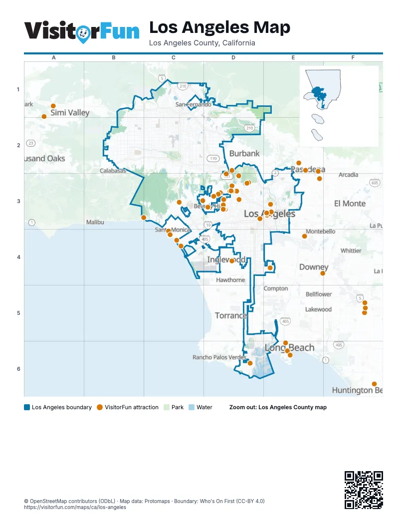
Street index of Los Angeles
Each street on the sheet and the grid squares it crosses.
- Ronald Reagan FreewayB1, C1
- Antelope Valley FreewayC1
- Foothill FreewayC1, D1, D2
- Golden State FreewayC1, C2, D2, D3, E3
- San Diego FreewayC1, C2, C3, C4, D4, D5
- Ventura FreewayB2, C2, D2, E2
- Colorado Street Freeway ExtensionD2
- Hollywood FreewayD2, D3, E3
- Route 101D2
- Santa Monica FreewayC3, D3, E3
- Glendale FreewayD3, E3
- Harbor FreewayD3, E3, D4, D5, D6
- Harbor TransitwayD3, D4, D5
- Arroyo Seco ParkwayE3
- East Aliso StreetE3
- East Arcadia StreetE3
- I-10 Metro ExpressLanesE3
- Long Beach FreewayE3
- Pomona FreewayE3
- Route 10E3
- San Bernardino FreewayE3
- Santa Ana FreewayE3, E4
- Marina FreewayC4, D4
- Century FreewayD4, E4
- I-110 Metro ExpressLanesD4
- Gardena FreewayD5
- Terminal Island FreewayE5, E6
- Seaside FreewayD6, E6
Things to do on the Los Angeles map
- Academy Museum of Motion Pictures
- Amoeba Music Hollywood
- Angels Flight Railway
- Catalina Express
- Chateau Marmont
- Crypto.com Arena
- Dodger Stadium
- Dolby Theatre
- Getty Villa
- Grand Central Market
- Greek Theatre
- Griffith Observatory
- Hollywood Bowl
- Hollywood Bus Tours
- Hollywood Pantages Theatre
- Hollywood Sign
- Hollywood Walk of Fame
- La Brea Tar Pits
- Los Angeles County Museum of Art (LACMA)
- Melrose Trading Post
- Olvera Street
- Original Farmers Market & The Grove
- Paramount Studio Tour
- Petersen Automotive Museum
- Ripley's Believe It or Not Hollywood
- TCL Chinese Theatre
- The Broad
- The Getty Center
- Venice Beach Boardwalk
- Walt Disney Concert Hall
- Watts Towers
Places on the map
- 4th Street Yard
- Aliso Canyon Park
- Angeles National Golf Club
- Arroyo Seco
- Balboa Municipal Golf Course
- Ballona Creek
- Ballona Lagoon
- Bank of America
- Bel-Air Country Club
- Bell Canyon Park
- Berths 206-209
- Big Tujunga Wash Open Space
- Braemar Country Club
- Brentwood Country Club
- Browns Creek Park
- Cabrillo Beach
- Corporate Pointe
- Deervale-Stone Canyon Park
- Dockweiler State Beach
- El Caballero Country Club
- Elysian Park
- Encino Municipal Golf Course
- Encino Reservoir
- Ernest E. Debs Regional Park
- Evergreen Container Terminal
- Fond Family Open Space
- Fryman Canyon Park
- G2 Parcel
- Getty View Park
- Griffith Park
- Hansen Dam Recreation Area
- Harding Golf Course
- Hermon Park (Arroyo Seco Park)
- Hillcrest at Porter Ranch
- Hillcrest Country Club
- Hilton Open Space
- Historic Filipinotown
- Hollywood Reservoir
- Joseph Jensen Treatment Plant
- Knollwood Country Club
Next to Los Angeles
- Agoura Hills
- Alhambra
- Altadena
- Arcadia
- Baldwin Park
- Bellflower
- Beverly Hills
- Buena Park
- Burbank
- Calabasas
- Carson
- Compton
- Culver City
- Cypress
- Downey
- Duarte
- El Monte
- Fountain Valley
- Gardena
- Glendale
- Hawthorne
- Huntington Beach
- Huntington Park
- Inglewood
- La Cañada Flintridge
- La Mirada
- La Puente
- Lakewood
- Lomita
- Long Beach map
- Los Alamitos
- Malibu
- Manhattan Beach
- Monrovia
- Montebello
- Monterey Park
- Norwalk
- Pasadena
- Pico Rivera
- Rancho Palos Verdes
- Redondo Beach
- Rosemead
- San Fernando
- Santa Fe Springs
- Santa Monica
- Seal Beach
- Sierra Madre
- Signal Hill
- Simi Valley
- South Gate
- Thousand Oaks
- Torrance
- West Hollywood
- Westminster
- Whittier
© OpenStreetMap contributors (ODbL) · Map data: Protomaps · Boundary: Who's On First (CC-BY 4.0)