

New York map
Downstate New York map
The sheet's index lists 35 highways; NY 27, I-87 and I-495 cross the most grid squares. Things to do inside the boundary: & Juliet, 9/11 Memorial & Museum and Adventureland. Also on it: Bay Shore, Brentwood and Brewster.
Open the map (PDF, US Letter)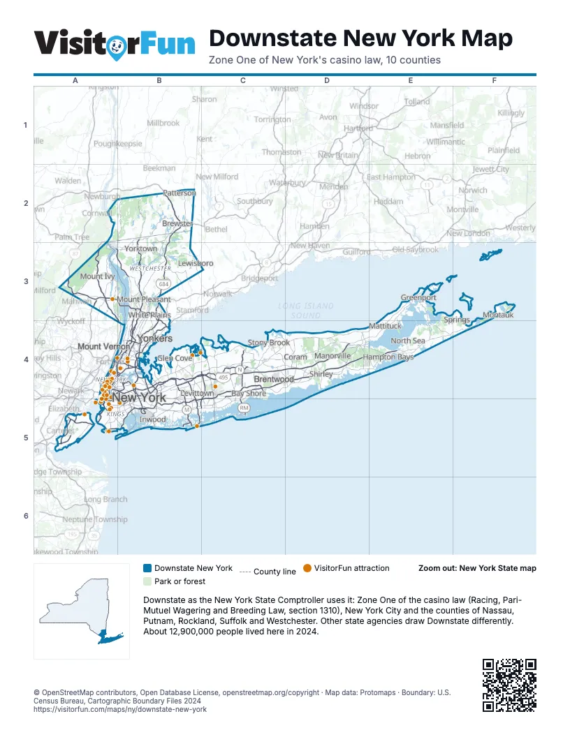
Highway index of Downstate New York
Each highway on the sheet and the grid squares it crosses.
- I-78A4
- I-84B2
- I-87A3, A4, B3, B4
- I-95A4, B4
- I-278A4, A5, B4
- I-287A3, B3, B4
- I-295B4
- I-495A4, B4, C4, D4
- I-678B4, B5
- I-684B2, B3
- I-695B4
- US 1A4, B4
- US 6A3
- US 9A3, A4, B2, B3
- US 9WA3
- US 202A3, B3
- NY 9AA4, B3, B4
- NJ 17A3
- NY 17A3
- NY 22B2
- NY 24D4
- NY 25A4, E3
- NY 25AD4
- NY 27A5, B5, C4, C5, D4, E4, F3, F4
- NY 35B3
- NY 100B3
- NY 118B3
- NY 135B5, C4, C5
- NY 303A3
- NY 347C4, D4
- NY 440A5
- NY 454C4, D4
- NJ 495A4
- NY 495A4
- NY 878B5
Things to do on the Downstate New York map
- & Juliet
- 9/11 Memorial & Museum
- Adventureland
- AKA New York
- Aladdin (Broadway)
- Aloft Manhattan Downtown - Financial District
- American Museum of Natural History
- Apollo Theater
- Applebee's Grill + Bar Times Square
- B&H Photo Video
- Barclays Center
- Best Western Plus Soho Hotel
- Big Bus Tours New York
- Birdland
- Blue Note Jazz Club
- Bronx Music Hall
- Bronx Zoo
- Brooklyn Botanic Garden
- Brooklyn Bridge
- Bryant Park
- Buena Vista Social Club
- Carnegie Hall
- Central Park
- Central Park Zoo
- Charging Bull
- Chelsea Market
- Chicago the Musical
- Chinatown
- Chrysler Building
- Circle Line Sightseeing Cruises
- Citi Field
- Coney Island
- Dallas BBQ Times Square
- Dave & Buster's Times Square
- DoubleTree by Hilton New York Downtown
- Dumbo
- Edge NYC
- Empire State Building
- Fifth Avenue
- Flatiron Building
- Fraunces Tavern Museum
- General Grant National Memorial
- Governors Island
- Grand Central Terminal
- Greenwich Village
- Hadestown (Broadway)
- Harlem
- Harry Potter and the Cursed Child
- Hilton New York Times Square
- Holiday Inn NYC - Lower East Side
- Hudson Yards
- Intrepid Museum
- Intrepid Sea, Air & Space Museum
- Jones Beach State Park
- Just in Time (Broadway)
- Katz's Delicatessen
- Lincoln Center
- Little Italy
- Little Shop of Horrors (Off-Broadway)
- Lower Manhattan
- Luna Park
- Macy's Herald Square
- Madame Tussauds New York
- Madison Square Garden
- Maybe Happy Ending
- Metropolitan Opera
- MJ The Musical (Broadway)
- Nathan's Famous
- New York Aquarium
- New York Botanical Garden
- New York City Ballet
- New York Public Library
- Oculus
- One Times Square
- One World Observatory
- Operation Mincemeat: A New Musical
- Palisades Center
- Peter Luger Steak House
- Prospect Park
- Radio City Music Hall
- Real's Tours NYC
- Rockefeller Center
- Sagamore Hill National Historic Site
- SIX: The Musical
- Snug Harbor Cultural Center & Botanical Garden
- SoHo
- Solomon R. Guggenheim Museum
- St. Patrick's Cathedral
- Staten Island Ferry
- Statue of Liberty & Ellis Island
- Stonewall National Monument
- Stranger Things: The First Shadow
- SUMMIT One Vanderbilt
- The Battery
- The Book of Mormon (Broadway)
- The Frick Collection
- The Great Gatsby (Broadway)
- The High Line
- The Lion King (Broadway)
- The Lost Boys: A New Musical
- The Met Cloisters
- The Metropolitan Museum of Art
- The Museum of Broadway
- The Museum of Modern Art (MoMA)
- The Outsiders (Broadway)
- The Play That Goes Wrong
- The Plaza
- The Rocky Horror Show (Broadway)
- The Tour at NBC Studios
- The WaterFront Center
- Titanique
- TKTS Times Square
- Top of the Rock Observation Deck
- Trinity Church
- TRYP by Wyndham New York City Times Square South
- Two Strangers (Carry a Cake Across New York)
- United Nations Headquarters
- Vessel
- Village Vanguard
- Wall Street
- Washington Square Park
- Welcome to Harlem
- Westgate New York Grand Central
- Whitney Museum of American Art
- Wicked (Broadway)
- Yankee Stadium Tours
Places on the map
- Bay Shore
- Brentwood
- Brewster
- Coram
- Glen Cove
- Greenport
- Hampton Bays
- Inwood
- Levittown
- Lewisboro
- Manorville
- Mattituck
- Montauk
- Mount Ivy
- Mount Pleasant
- Mount Vernon
- New York
- North Sea
- Patterson
- Shirley
- Springs
- Stony Brook
- White Plains
- Yonkers
- Yorktown
© OpenStreetMap contributors, Open Database License, openstreetmap.org/copyright · Map data: Protomaps · Boundary: U.S. Census Bureau, Cartographic Boundary Files 2024