

Wisconsin map
Milwaukee map
About 563,531 people live here (Census Bureau, 2024 estimate). The sheet's index lists 176 streets; North 60th Street, North Sherman Boulevard and North-South Freeway cross the most grid squares. Things to do inside the boundary: American Family Field, Discovery World and Edelweiss Cruise Lines.
Open the map (PDF, US Letter)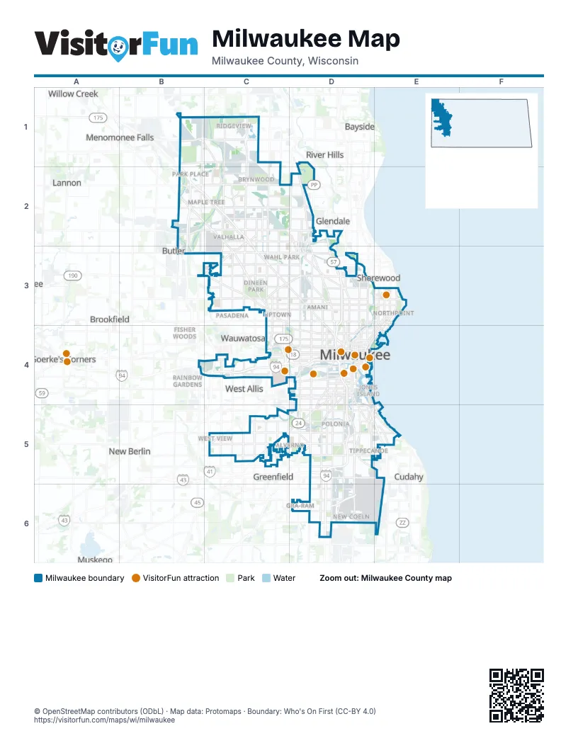
Street index of Milwaukee
Each street on the sheet and the grid squares it crosses.
- Main StreetB1
- North 124th StreetB1, B2
- West Brown Deer RoadB1, C1
- North 60th StreetC1, C2, C3, C4
- North 76th StreetC1, C2, C3
- North 91st StreetC1, C2, C3
- Wauwatosa RoadC1
- Appleton AvenueB2
- Fond du Lac FreewayB2, C2, C3
- Good Hope RoadB2
- North Lovers Lane RoadB2, B3
- State Highway 145B2
- West Appleton AvenueB2, C2, C3
- West Good Hope RoadB2, C2, D2
- West Silver Spring DriveB2, C2, D2
- Zoo FreewayB2, B3, C4
- North Sherman BoulevardC2, D2, C3, D3
- West Mill RoadC2, D2
- North 43rd StreetD2
- North Green Bay AvenueD2, D3
- North Hopkins StreetD2, D3
- North Teutonia AvenueD2, D3
- West Custer AvenueD2
- North Mayfair RoadB3, B4
- West Capitol DriveB3, C3, D3
- West Hampton AvenueB3, C3, D3
- North 100th StreetC3
- North 46th StreetC3
- North 51st BoulevardC3
- North 51st StreetC3
- North 55th StreetC3, C4
- North 92nd StreetC3
- North Swan RoadC3
- West Burleigh StreetC3, D3
- West Center StreetC3, D3
- West Fond du Lac AvenueC3, D3, D4
- West Lisbon AvenueC3, C4, D4
- West North AvenueC3, D3
- West Roosevelt DriveC3, D3
- East Capitol DriveD3
- East Center StreetD3
- East Hampton AvenueD3
- East Locust StreetD3, E3
- East North AvenueD3, E3
- North 12th StreetD3, D4
- North 20th StreetD3, D4
- North 27th StreetD3, D4
- North 31st StreetD3
- North 32nd StreetD3
- North 35th StreetD3, D4
- North 7th StreetD3
- North 8th StreetD3
- North Doctor Martin Luther King Junior DriveD3, D4
- North Halyard StreetD3, D4
- North Holton StreetD3, D4
- North Humboldt AvenueD3, D4
- North Humboldt BoulevardD3
- North Port Washington AvenueD3
- North Port Washington RoadD3
- North-South FreewayD3, D4, D5, D6
- West Atkinson AvenueD3
- West Garfield AvenueD3
- West Hopkins StreetD3
- West Keefe AvenueD3
- West Locust StreetD3
- East Bradford AvenueE3
- East Kenwood BoulevardE3
- North Downer AvenueE3
- North Farwell AvenueE3, D4, E4
- North Lake DriveE3, E4
- North Lincoln Memorial DriveE3, D4, E4
- North Oakland AvenueE3, E4
- North Prospect AvenueE3, D4, E4
- East-West FreewayB4, C4, D4
- West Bluemound RoadB4, C4
- Brewers BoulevardC4
- North 45th StreetC4
- North Glenview AvenueC4
- North Hawley RoadC4
- South 60th StreetC4, C5
- South 84th StreetC4
- South Hawley RoadC4
- West Greenfield AvenueC4, D4
- West Lloyd StreetC4
- West National AvenueC4, D4
- West State StreetC4, D4
- West Vliet StreetC4, D4
- West Wisconsin AvenueC4, D4
- East Brady StreetD4, E4
- East Clybourn StreetD4
- East Juneau AvenueD4
- East Kilbourn AvenueD4
- East Knapp StreetD4
- East Michigan StreetD4
- East Pittsburgh AvenueD4
- East Pleasant StreetD4
- East Saint Paul AvenueD4
- East State StreetD4
- East Wells StreetD4
- East Wisconsin AvenueD4
- John R. Plewa Memorial Lake ParkwayD4, E4, D5, E5
- Lake FreewayD4, E4
- North 16th StreetD4
- North 17th StreetD4
- North 6th StreetD4
- North BroadwayD4
- North Cambridge AvenueD4, E4
- North Franklin PlaceD4
- North Jackson StreetD4
- North Milwaukee StreetD4
- North Renee StreetD4
- North Van Buren StreetD4
- North Water StreetD4
- North Young StreetD4
- South 10th StreetD4
- South 11th StreetD4
- South 13th StreetD4, D5, D6
- South 16th StreetD4, D5
- South 1st StreetD4, D5
- South 35th StreetD4, D5
- South 6th StreetD4, D5
- South 9th StreetD4
- South Kinnickinnic AvenueD4, D5, E5
- South Layton BoulevardD4, D5
- South Muskego AvenueD4, D5
- South Water StreetD4
- West Clybourn StreetD4
- West Forest Home AvenueD4, C5, D5
- West Highland AvenueD4
- West Highland BoulevardD4
- West Juneau AvenueD4
- West Kilbourn AvenueD4
- West Lapham BoulevardD4
- West McKinley AvenueD4
- West Michigan StreetD4
- West Mineral StreetD4
- West Pleasant StreetD4
- West Tory Hill StreetD4
- West Walker StreetD4
- West Walnut StreetD4
- West Wells StreetD4
- West Windlake AvenueD4, D5
- West Winnebago StreetD4
- East Lafayette Hill RoadE4
- East Lafayette PlaceE4
- South 43rd StreetC5
- South 76th StreetC5
- South 92nd StreetC5
- West Beloit RoadC5
- West Oklahoma AvenueC5, D5
- Airport FreewayD5
- East Bay StreetD5
- East Becher StreetD5
- East Howard AvenueD5, E5
- East Layton AvenueD5, E5
- East Lincoln AvenueD5, E5
- East Oklahoma AvenueD5, E5
- South 27th StreetD5, D6
- South 5th PlaceD5
- South Bay StreetD5
- South Carferry DriveD5, E5
- South Chase AvenueD5
- South Clement AvenueD5
- South Howell AvenueD5, D6
- West Becher StreetD5
- West Howard AvenueD5
- West Layton AvenueD5
- West Lincoln AvenueD5
- West Loomis RoadD5
- East Russell AvenueE5
- South Lake DriveE5
- South Lincoln Memorial DriveE5
- South Superior StreetE5
- Airport SpurD6
- East College AvenueD6, E6
- West College AvenueD6
Things to do on the Milwaukee map
Places on the map
- 128th Air Refueling Wing
- 30th Street Corridor
- Alameda Place
- Alcott Park
- Alter Metal Recycling
- Alverno
- Amani
- Arlington Court
- Arlington Gardens
- Arlington Heights
- Aurora Sinai Medical Center
- Avenues West
- Ball Industrial
- Baran Park
- Bay View
- Bay View Historic District
- Beerline B
- Beerline Trail
- Berryland
- Bluemound Heights
- BMO Harris Building
- Borchert Field
- Bradley Estates
- Bradley Townhomes
- Brewers Hill
- Brewers Hill Historic District
- Brewery Silo
- BRIA of Trinity Village
- Brown Deer Park
- Brown Deer Park Golf Course
- Brynwood
- Burnham Park
- Butchel Park
- Calumet Farms
- Calvary Cemetery
- Cambridge Woods
- Cannon Park
- Capitol Heights
- Castle Manor
- Cathedral Church of All Saints
Next to Milwaukee
- Bayside
- Biwer's Woods
- Brookfield
- Butler
- Civic Center
- Cudahy
- Eckel Woods
- Fisher Woods
- Glendale
- Goerke's Corners
- Greenfield
- Greenfield Park
- Historic Heights
- Lannon
- Mayfair Park
- Menomonee Falls
- Muskego
- New Berlin
- Orchard Hills
- Pasadena
- Rainbow Gardens
- River Hills
- Saint Francis
- Shorewood
- South Milwaukee
- Wauwatosa
- West Allis
- Whitefish Bay
- Willow Creek
- Wood Dale
© OpenStreetMap contributors (ODbL) · Map data: Protomaps · Boundary: Who's On First (CC-BY 4.0)