

Ohio map
Cleveland Metro Area map
The sheet's index lists 30 highways; I-90, I-271 and SR 2 cross the most grid squares. Things to do inside the boundary: A Christmas Story House & Museum, B.A. Sweetie Candy Company and Beachcliff Market Square. Also on it: Ashtabula, Avon Lake and Brecksville.
Open the map (PDF, US Letter)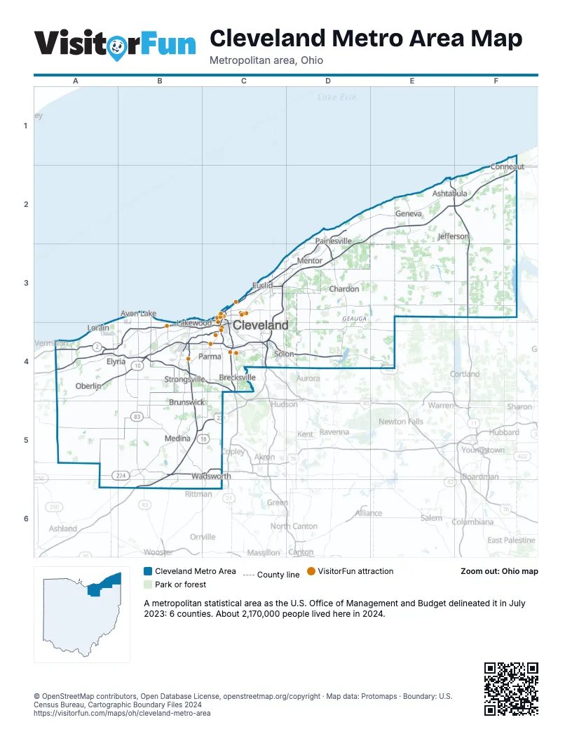
Highway index of Cleveland Metro Area
Each highway on the sheet and the grid squares it crosses.
- I-71B4, B5, B6, C4
- I-76B5, C5
- I-77C3, C4
- I-80A4, B4, C4
- I-90A4, B4, C3, C4, D2, D3, E2, F2
- I-271B5, C3, C4, C5, D3
- I-480B4, C4
- I-480NC4
- I-490C4
- US 6C3
- US 20A4, B4, C3
- US 42B5
- US 224A5, B5, C5
- US 422C4, D4, E4
- SR 2A4, B4, C3, D2, D3
- SR 3B5
- SR 10B4, C3, C4
- SR 11E2, F2, F3
- SR 14C4
- SR 18B5, C5
- SR 44D2, D3
- SR 57A4, B4, B5, C5, C6
- SR 83B4, B5, B6
- SR 113A4, B4
- SR 176C4
- SR 237B4
- SR 252B5
- SR 283C3
- SR 301A4, B4
- SR 303B5
Things to do on the Cleveland Metro Area map
- A Christmas Story House & Museum
- B.A. Sweetie Candy Company
- Beachcliff Market Square
- Children's Museum of Cleveland
- Chippewa Lake Park
- Cleveland Botanical Garden
- Cleveland Cultural Gardens
- Cleveland History Center
- Cleveland Lakefront Nature Preserve
- Cleveland Mall
- Cleveland Metroparks Zoo
- Cleveland Museum of Art
- Cleveland Museum of Natural History
- Comfort Inn Cleveland Airport
- Comfort Inn Downtown
- Common Ground Canopy Tour
- Cuyahoga Valley Scenic Railroad
- Dave & Buster's Westlake - Cleveland
- David Berger National Memorial
- Drury Plaza Hotel Cleveland Downtown
- Goodtime III Sightseeing Cruise
- Great Lakes Brewing Company
- Great Lakes Science Center
- Greater Cleveland Aquarium
- Hogback Ridge Metropolitan Park
- Italian American Museum of Cleveland
- JACK Cleveland Casino
- James A. Garfield Memorial
- James A. Garfield National Historic Site
- Lady Caroline
- Lady Caroline Cruises
- Lake Metroparks Farmpark
- Lake View Cemetery
- Legacy Village
- Maltz Museum of Jewish Heritage
- Museum of Contemporary Art Cleveland (moCa)
- Playhouse Square
- Pymatuning State Park (Ohio)
- Ramada by Wyndham Cleveland Independence
- Rock & Roll Hall of Fame
- Severance Music Center
- Sir Troy's Toy Kingdom
- SouthPark Mall
- Steelyard Commons
- The Arcade Cleveland
- The Funny Bus Cleveland
- USS Cod Submarine Memorial
- West Side Market
- Western Reserve Historical Society
Places on the map
- Ashtabula
- Avon Lake
- Brecksville
- Brunswick
- Chardon
- Cleveland
- Conneaut
- Elyria
- Euclid
- Geneva
- Jefferson
- Lakewood
- Lorain
- Medina
- Mentor
- Oberlin
- Painesville
- Parma
- Solon
- Strongsville
- Wadsworth
© OpenStreetMap contributors, Open Database License, openstreetmap.org/copyright · Map data: Protomaps · Boundary: U.S. Census Bureau, Cartographic Boundary Files 2024