

Florida map
Miami-Fort Lauderdale-West Palm Beach Metro Area map
The sheet's index lists 32 highways; US 1, US 27 and I-75 cross the most grid squares. Things to do inside the boundary: AMR Homestead-Miami Motorplex, Aqua Adventure Tours and Art Deco Historic District & Ocean Drive. Also on it: Belle Glade, Boca Raton and Boynton Beach.
Open the map (PDF, US Letter)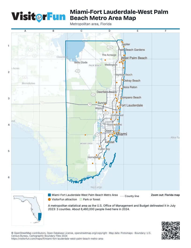
Highway index of Miami-Fort Lauderdale-West Palm Beach Metro Area
Each highway on the sheet and the grid squares it crosses.
- I-75B3, C3, D3, D4
- I-95D1, D2, D3, D4
- I-195D4
- I-395D4
- I-595D3
- US 1C5, C6, D4, D5, D6
- US 27B1, C2, C3, D3, D4
- US 41C4, D4
- US 98C1, C2, D2
- US 441C1, C2, D2
- SR 9D4
- SR 15C1, C2
- SR 80B1, C2, D2
- SR 112D4
- SR 708D1
- SR 710D1
- SR 820D4
- SR 823D3, D4
- SR 826D4, D5
- SR 836D4
- SR 838D3
- SR 856D4
- SR 869D3
- SR 870D3
- SR 874D4, D5
- SR 878D5
- SR 887D4
- SR 907D4
- SR 924D4
- SR 953D4
- SR 997C4, C5, D4
- SR 998C5
Things to do on the Miami-Fort Lauderdale-West Palm Beach Metro Area map
- AMR Homestead-Miami Motorplex
- Aqua Adventure Tours
- Art Deco Historic District & Ocean Drive
- Aventura Mall
- Aviation Museum On The Beach
- Bal Harbour Shops
- Ball & Chain
- Bayfront Park
- Bayside Marketplace
- Best Western Palm Beach Lakes
- Big Bus Tours Miami
- Biscayne National Park
- Bloomingdale's Aventura
- Blue Water Boat Rentals
- Bluefoot Pirate Adventures
- Boca Raton History Museum
- Boca Raton Museum of Art
- Bonnet House Museum & Gardens
- Boynton Beach Mall
- Brickell City Centre
- Butterfly World
- Charles Deering Estate
- Club Wyndham Palm-Aire
- Club Wyndham Royal Vista
- Collins Park
- Coral Castle
- Cox Science Center & Aquarium
- Cultural Council for Palm Beach County
- Dania Pointe
- Delray Yacht Cruises
- Escapology
- Everglades Alligator Farm
- Everglades Day Safari
- Everglades Holiday Park
- Everglades National Park
- Everglades Safari Park
- Everglades Swamp Tours
- Fairchild Tropical Botanic Garden
- Fetched Up Charters
- Fishing Headquarters
- Flagler Museum
- Flamingo Gardens
- Fontainebleau Miami Beach
- Girls' Club Foundation
- Gulfstream Park
- Gumbo Limbo Environmental Complex
- Hard Rock Stadium
- Haulover Park
- Hilton Garden Inn West Palm Beach I95 Outlets
- Hilton Palm Beach PBI
- History Fort Lauderdale
- Holocaust Memorial Miami Beach
- iSkydive Miami
- Island Queen Cruises, Millionaire's Row Cruise
- Joe's Stone Crab
- Jungle Island
- Jungle Queen Riverboat
- Jupiter Beach Resort & Spa
- Jupiter Inlet Lighthouse & Museum
- Kravis Center for the Performing Arts
- Lincoln Road
- Lion Country Safari
- Little Havana & Calle Ocho (Domino Park)
- Loggerhead Marinelife Center
- Luminosa at Jungle Island
- Lummus Park
- Mai Kai Restaurant
- Maurice A. Ferré Park
- Miami Children's Museum
- Morikami Museum and Japanese Gardens
- Mounts Botanical Garden
- Museum of Miami
- North Miami Museum of Contemporary Art
- Palm Beach Kennel Club
- Palm Beach Zoo & Conservation Society
- Pérez Art Museum Miami
- Phillip and Patricia Frost Museum of Science
- Sandoway Discovery Center
- Sawgrass Mills
- Sawgrass Recreation Park
- Sea Experience
- Sea Mist III
- Sea Rocket
- Seminole Casino Coconut Creek
- Seminole Hard Rock Hotel & Casino Hollywood
- Shark Valley Observation Tower
- Shark Valley Tram Tours
- Sheraton Suites Fort Lauderdale at Cypress Creek
- Skyviews Miami Observation Wheel
- South Pointe Park
- Southland Mall
- Sunny Miami Tours
- The Barnacle Historic State Park
- The Bass Museum of Art
- The Escape Game Miami
- The Galleria at Fort Lauderdale
- The Gardens Mall
- The Kampong
- The Mall at Wellington Green
- The Shops at Sunset Place
- Therapy IV Deep Sea Fishing
- Thriller Miami Speedboat Adventures
- Town Center at Boca Raton
- Treetop Trekking Miami
- Venetian Pool
- Versailles Restaurant
- Visit Palm Beach Visitor Information & Adventure Center
- Vizcaya Museum & Gardens
- Water Taxi Fort Lauderdale
- Wynwood Walls
- Xtreme Action Park
- Zoo Miami
Places on the map
- Belle Glade
- Boca Raton
- Boynton Beach
- Cutler Bay
- Deerfield Beach
- Delray Beach
- Doral
- Fort Lauderdale
- Hollywood
- Homestead
- Jupiter
- Kendall
- Miami
- North Miami
- Palm Beach Gardens
- Pompano Beach
- Sunrise
- The Acreage
- Wellington
- West Palm Beach
- Weston
© OpenStreetMap contributors, Open Database License, openstreetmap.org/copyright · Map data: Protomaps · Boundary: U.S. Census Bureau, Cartographic Boundary Files 2024