

Texas map
Houston map
About 2,390,125 people live here (Census Bureau, 2024 estimate). The sheet's index lists 55 streets; Northwest Freeway, US 59 (Eastex Freeway) HOV/HOT lane and Hardy Toll Road cross the most grid squares. Things to do inside the boundary: Buffalo Bayou Park, Children's Museum Houston and Downtown Aquarium Houston.
Open the map (PDF, US Letter)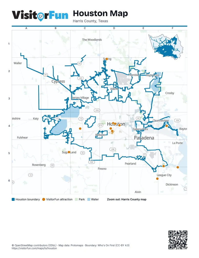
Street index of Houston
Each street on the sheet and the grid squares it crosses.
- Northwest FreewayA2, B2, B3, C3, D4
- Grand ParkwayC2
- Tomball ParkwayC2, C3
- Tomball TollwayC2
- Hardy Toll RoadD2, D3, D4
- Hardy Toll Road Airport ConnectorD2
- North FreewayD2, D3, D4
- Eastex FreewayE2, D3, D4
- US 59 (Eastex Freeway) HOV/HOT laneE2, D3, E3, D4
- North Sam Houston Tollway WestC3, D3
- West Sam Houston Tollway NorthC3, C4
- North Sam Houston Parkway EastD3, E3
- North Sam Houston Parkway WestD3
- Katy FreewayB4, C4, D4
- Katy TollwayB4, C4, D4
- West Grand Parkway NorthB4
- West Grand Parkway SouthB4
- Southwest FreewayC4, D4, C5
- US 59 (Southwest Freeway) HOV/HOT laneC4, D4, C5
- West Sam Houston Tollway SouthC4, C5
- Westpark TollwayC4
- Westpark Tollway RampC4
- Alvin FreewayD4
- East FreewayD4, E4, F4
- Gulf FreewayD4, E4, E5
- North LoopD4
- North Loop EastD4, E4
- North Loop WestD4
- Pierce ElevatedD4
- South FreewayD4, D5
- South Loop EastD4, E4, D5
- West Loop NorthD4
- West Loop SouthD4, D5
- Crosby FreewayE4
- East Loop NorthE4
- East Loop SouthE4
- East Sam Houston Tollway NorthE4
- East Sam Houston Tollway SouthE4, E5
- La Porte FreewayE4
- Pasadena FreewayE4
- Chimney Rock RoadC5
- Fort Bend Parkway Toll RoadC5
- Fort Bend Toll RoadC5
- South Post Oak RoadC5, D5
- South Sam Houston Parkway WestC5
- South Sam Houston Tollway WestC5, D5
- West Sam Houston Parkway SouthC5
- Sam Houston Tollway EastD5
- South Loop WestD5
- South Sam Houston Tollway EastD5, E5
- East Sam Houston Parkway SouthE5
- Monroe Pr One DriveE5
- Monroe Pr Two DriveE5
- South Sam Houston Parkway EastE5
- NASA BypassF6
Things to do on the Houston map
Places on the map
- Addicks Reservoir
- Afton Oaks
- Alexander Deussen Park
- Almeda Plaza
- America Plaza
- American Shooting Center
- Antoine Greenspace
- Ayrshire
- Barker Reservoir
- Barrington Kingwood
- Baybrook Mall
- Bayou Estates
- Bayou Pond
- Bayou Woods
- Bear Creek Golf World
- Bear Creek Woods
- Beltway 8 Corporate Centre
- Binglewood
- Blue Ridge (County) Park
- BraeBurn Country Club
- Braeburn Glen
- Braeburn Valley West
- Braes Heights
- Briargrove
- Brock Adventure Park
- Brooke Smith
- City Gate
- City Park West
- Clearwater
- Clinton Park
- Coolgreen Park
- Corinthian Pointe
- Crestmont
- Crestmont Park
- Cypress Mill Plaza
- Dwight D. Eisenhower Park
- East End Park
- East River
- Eco-Park
- El Franco Lee Park
Next to Houston
- Aldine
- Alvin
- Baytown
- Bellaire
- Brookshire
- Channelview
- Crosby
- Dickinson
- Fresno
- Friendswood
- Fulshear
- Galena Park
- Humble
- Jersey Village
- Katy
- La Porte
- League City
- Manvel
- Missouri City
- Pasadena
- Pearland
- Rosenberg
- South Houston
- Spring
- Sugar Land
- The Woodlands
- Waller
© OpenStreetMap contributors (ODbL) · Map data: Protomaps · Boundary: Who's On First (CC-BY 4.0)