

Texas map
Harris County map
About 5,009,302 people live here (Census Bureau, 2024 estimate). The sheet's index lists 67 streets; Northwest Freeway, North Grand Parkway East and Hardy Toll Road cross the most grid squares. Things to do inside the boundary: Buffalo Bayou Park, Children's Museum Houston and Downtown Aquarium Houston.
Open the map (PDF, US Letter)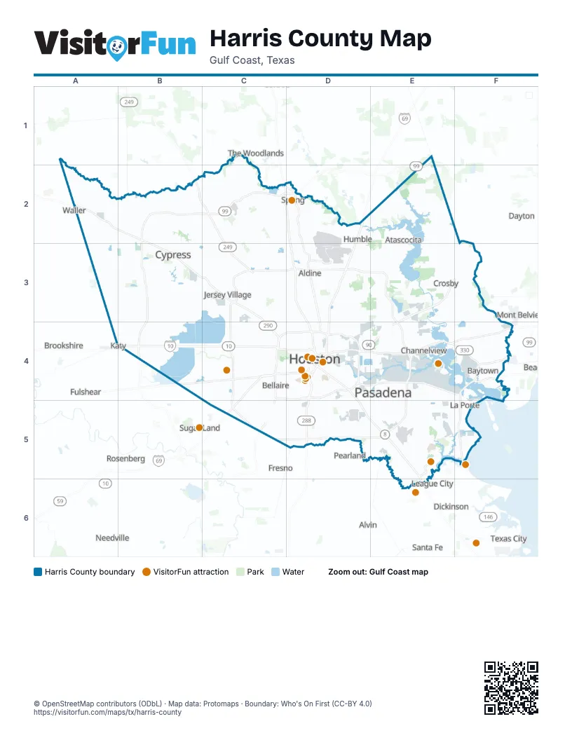
Maps inside Harris County
1 map inside, from the street map of Harris County down.
Street index of Harris County
Each street on the sheet and the grid squares it crosses.
- North Grand Parkway EastE1, C2, D2, E2
- Northwest FreewayA2, B2, B3, C3, C4
- Grand ParkwayB2, C2
- North Grand Parkway WestB2, C2
- Tomball TollwayB2, C2
- West Grand Parkway NorthB2, B3, B4
- Hardy Toll RoadC2, D2, D3, D4
- North FreewayC2, D2, D3, D4
- Tomball ParkwayC2, C3
- Eastex FreewayD2, D3, D4
- US 59 (Eastex Freeway) HOV/HOT laneD2, D3, D4
- North Sam Houston Parkway WestC3, D3
- North Sam Houston Tollway WestC3, D3
- West Sam Houston Tollway NorthC3, C4
- Hardy Toll Road Airport ConnectorD3
- North Sam Houston Parkway EastD3
- North Sam Houston Tollway EastD3, E3
- Crosby FreewayE3, F3, D4, E4
- East Sam Houston Tollway NorthE3, E4
- Fort Bend Westpark TollwayB4
- Katy FreewayB4, C4, D4
- Katy TollwayB4, C4
- West Grand Parkway SouthB4
- Westpark TollwayB4, C4
- North Loop WestC4, D4
- South Loop WestC4, D4
- Southwest FreewayC4, D4, C5
- US 59 (Southwest Freeway) HOV/HOT laneC4, D4, C5
- West Loop NorthC4
- West Loop SouthC4
- West Sam Houston Parkway SouthC4, C5
- West Sam Houston Tollway SouthC4
- Westpark Tollway RampC4
- Alvin FreewayD4
- East FreewayD4, E4, F4
- East Loop NorthD4
- East Loop SouthD4
- Gulf FreewayD4, D5, E5, E6
- La Porte FreewayD4, E4, F4
- North LoopD4
- North Loop EastD4
- Pierce ElevatedD4
- South FreewayD4, D5
- South Loop EastD4
- Decker DriveE4, F4
- East Sam Houston Parkway NorthE4
- East Sam Houston Tollway SouthE4, E5
- Pasadena FreewayE4
- East Grand Parkway SouthF4
- Fred Hartman BridgeF4
- North Robert C Lanier FreewayF4
- South Robert C Lanier FreewayF4
- Chimney Rock RoadC5
- Fort Bend Toll RoadC5
- South Post Oak RoadC5
- South Sam Houston Parkway WestC5
- South Sam Houston Tollway WestC5, D5
- Brazoria County ExpresswayD5
- Monroe Pr One DriveD5
- Monroe Pr Two DriveD5
- Sam Houston Tollway EastD5
- South Sam Houston Tollway EastD5, E5
- East Sam Houston Parkway SouthE5
- NASA BypassE5
- South Sam Houston Parkway EastE5
- Bayport BoulevardF5
- North Gulf FreewayE6
Things to do on the Harris County map
Places on the map
- Addicks Reservoir
- Afton Oaks
- Airline
- Alden Woods
- Alder Trails
- Aldine
- Aldine North
- Alexander Deussen Park
- Almeda Plaza
- Altura Cogen Gas Power Plant
- America Plaza
- American Shooting Center
- Amira
- Antoine Greenspace
- Arkema Innovative Chemistry
- Armand Bayou Nature Center
- Ashford Grove
- Atasca Woods
- Atascocita Forest
- Atascocita Landfill
- Atascocita North
- Atascocita South
- Atascocita Trace
- Atascocita Trails
- Auburn Lakes Reserve
- Augusta Pines Golf Course
- Autumn Creek
- Autumn Lakes
- Ayrshire
- Barker Lake
- Barker Reservoir
- Barrington Kingwood
- Barwood
- Bauer Landing
- Bay Area Business Park
- Bay Area Shooters Club
- Bay Forest Golf Club
- Baybrook Mall
- Bayou Estates
- Bayou Pond
Next to Harris County
- Alvin
- Brookshire
- Dayton
- Dickinson
- Fresno
- Friendswood
- Fulshear
- Katy
- La Marque
- League City
- Manvel
- Missouri City
- Mont Belvieu
- Needville
- Pearland
- Rosenberg
- Santa Fe
- Sugar Land
- Texas City
- The Woodlands
- Waller
© OpenStreetMap contributors (ODbL) · Map data: Protomaps · Boundary: Who's On First (CC-BY 4.0)