

New York map
Buffalo-Cheektowaga Metro Area map
The sheet's index lists 22 highways; I-90, NY 16 and I-190 cross the most grid squares. Things to do inside the boundary: Anchor Bar, Aquarium of Niagara and Buckhorn Island State Park. Also on it: Amherst, Buffalo and East Aurora.
Open the map (PDF, US Letter)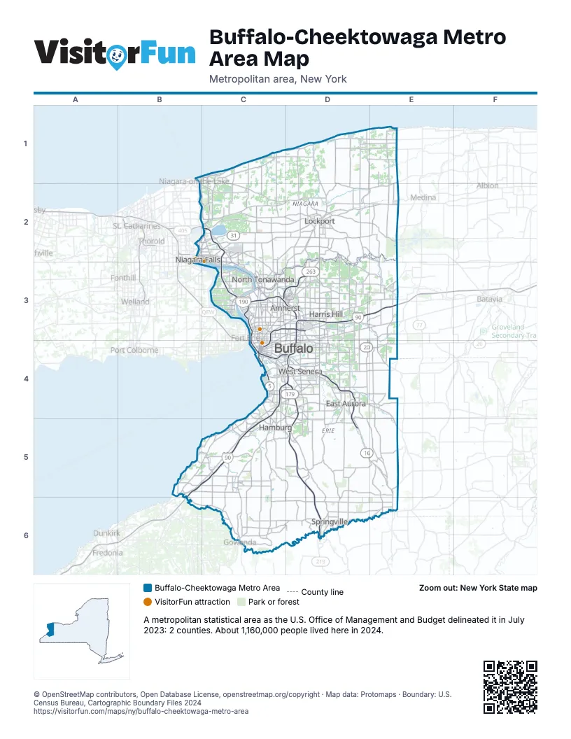
Highway index of Buffalo-Cheektowaga Metro Area
Each highway on the sheet and the grid squares it crosses.
- I-90B5, C4, C5, D3, D4, E3
- I-190C2, C3, C4, D4
- I-290C3, D3
- I-990C3, D3
- US 20D4, E4
- US 219D4, D5, D6
- NY 5C4
- NY 16C4, D4, D5, E5, E6
- NY 31C2, D2, E2
- NY 33C3, C4, D3
- NY 39D6, E6
- NY 78D2, D3, D4
- NY 93D2
- NY 130D4
- NY 179C4, D4
- NY 198C3
- NY 263D2, D3
- NY 277D4
- NY 324C3
- NY 384B2, C3
- NY 400D4, D5
- NY 429C2
Things to do on the Buffalo-Cheektowaga Metro Area map
- Anchor Bar
- Aquarium of Niagara
- Buckhorn Island State Park
- Buffalo AKG Art Museum
- Buffalo Harbor State Park
- Buffalo History Museum
- Buffalo Zoo
- Castellani Art Museum
- Cave of the Winds
- Cazenovia Park
- Chestnut Ridge Park
- Como Lake Park
- De Veaux Woods State Park
- Evangola State Park
- Fashion Outlets of Niagara Falls
- Golden Hill State Park
- Herschell Carrousel Factory Museum
- Maid of the Mist
- Martin Luther King Jr. Park
- McKinley Mall
- Museum of Disability History
- Niagara Amusement Park and Splash World
- Niagara Falls State Park
- Niagara Falls Underground Railroad Heritage Center
- Rainbow Air
- Reservoir State Park
- Seneca Niagara Resort & Casino
- Theodore Roosevelt Inaugural National Historic Site
- Walden Galleria
- Whirlpool State Park
- Wilson-Tuscarora State Park
- Woodlawn Beach State Park
Places on the map
- Amherst
- Buffalo
- East Aurora
- Hamburg
- Harris Hill
- Lockport
- Niagara Falls
- North Tonawanda
- Springville
- West Seneca
© OpenStreetMap contributors, Open Database License, openstreetmap.org/copyright · Map data: Protomaps · Boundary: U.S. Census Bureau, Cartographic Boundary Files 2024