

Louisiana map
New Orleans-Metairie Metro Area map
The sheet's index lists 16 highways; LA 23, I-10 and US 61 cross the most grid squares. Things to do inside the boundary: Airboat Adventures, Antoine's Restaurant and Audubon Aquarium of the Americas. Also on it: Gretna, Kenner and LaPlace.
Open the map (PDF, US Letter)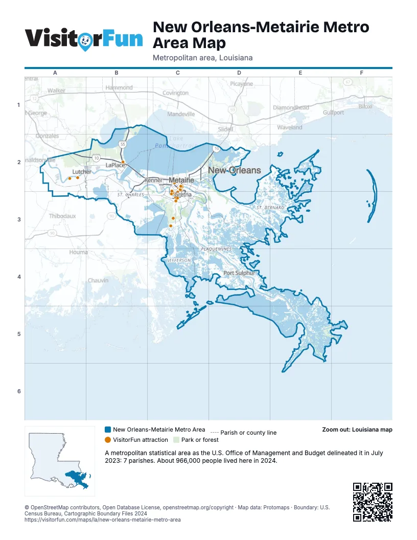
Highway index of New Orleans-Metairie Metro Area
Each highway on the sheet and the grid squares it crosses.
- I-10A2, B2, C2, D2
- I-55B1, B2
- I-310B2, B3
- I-510C2
- I-610C2
- US 51B1, B2
- US 61A2, B2, C2
- US 90B3, C2, C3
- LA 18C3
- LA 23C3, C4, D4, E4, E5
- LA 47C2
- LA 70A2
- LA 3046C2
- LA 3139C2
- LA 3152C2
- LA 3188B2
Things to do on the New Orleans-Metairie Metro Area map
- Airboat Adventures
- Antoine's Restaurant
- Audubon Aquarium of the Americas
- Audubon Park
- Audubon Zoo
- Bayou Segnette State Park
- Bourbon Street
- Caesars New Orleans
- Caesars Superdome
- Cafe Beignet
- Cafe du Monde
- Cajun Encounters Swamp Tours
- Cajun Pride Swamp Tours
- Cemetery Tours NOLA
- Central Grocery
- City Park
- Commander's Palace
- Confederate Memorial Hall
- Crescent City Brewhouse
- French Market
- French Quarter
- French Quarter Phantoms
- Frenchmen Street
- Friends of the Cabildo Walking Tours
- Galatoire's
- Garden District
- Godchaux–Reserve Plantation
- Gray Line New Orleans
- Haunted History Tours
- Hotel Monteleone
- Jackson Square
- JAMNOLA
- Jean Lafitte National Historical Park and Preserve
- Laura Plantation
- Longue Vue House and Gardens
- Louis Armstrong Park
- Louisiana Tour Company
- Madame John's Legacy
- Magazine Street
- Mardi Gras World
- Museum of the Southern Jewish Experience
- New Orleans African American Museum
- New Orleans Airboat Tours
- New Orleans City Sightseeing
- New Orleans Historic Voodoo Museum
- New Orleans Museum of Art
- New Orleans Native Tours
- New Orleans School of Cooking
- New Orleans Storyville Museum
- Newcomb Art Museum
- Oak Alley Plantation
- Oak Street
- Oakwood Center
- Oceana Grill
- Ogden Museum of Southern Art
- Old Ursuline Convent Museum
- Pat O'Brien's
- Perino's Boiling Pot
- Preservation Hall
- Royal Street
- Sazerac House
- Southern Style Tours
- St. Charles Avenue Streetcar
- St. Louis Cathedral
- St. Louis Cemetery No. 1
- Steamboat Natchez
- The Mortuary Haunted Mansion
- The National WWII Museum
- The Outlet Collection at Riverwalk
- Tipitina's
- Unique NOLA Tours
- Whitney Plantation
- Wild Louisiana Tours
Places on the map
- Gretna
- Kenner
- LaPlace
- Lutcher
- Metairie
- New Orleans
- Port Sulphur
© OpenStreetMap contributors, Open Database License, openstreetmap.org/copyright · Map data: Protomaps · Boundary: U.S. Census Bureau, Cartographic Boundary Files 2024