

Pennsylvania map
Philadelphia-Camden-Wilmington Metro Area map
The sheet's index lists 48 highways; US 1, US 13 and I-95 cross the most grid squares. Things to do inside the boundary: Independence Hall, Philadelphia Museum of Art and Reading Terminal Market. Also on it: Abington Township, Camden and Chester.
Open the map (PDF, US Letter)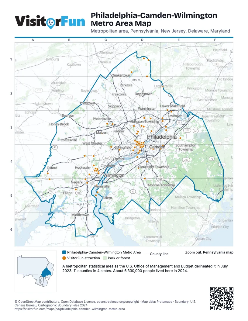
Highway index of Philadelphia-Camden-Wilmington Metro Area
Each highway on the sheet and the grid squares it crosses.
- I-76B3, C3, D3, D4
- I-95A5, B5, C4, C5, D3, D4, E3
- I-276C3, D3, E3
- I-295C4, C5, D4, E2, E3, E4
- I-476C1, C2, C3, C4, D3
- I-495C4, C5
- I-676D3, D4
- US 1A4, A5, B4, C3, C4, D3, E2, E3
- US 9F5
- US 13B5, B6, C4, C5, C6, D3, E2, E3
- US 30B3, C3, D3, D4, E4, E5
- US 40A5, B5, C5, D5, E5
- US 130C4, D3, D4, E3
- US 202C3, C4, C5, D2, D3, E2
- US 206E3, E4
- US 222A4, A5
- US 301B5, B6
- US 322B3, C3, C4, D4, D5, E5
- US 422B2, C2, C3
- DE 1B5, B6, C5, C6
- PA 3C3, D3
- DE 7B4, B5, C4
- DE 9C5
- NJ 38D4, E3, E4
- DE 41B4
- PA 41B3, B4
- NJ 42D4, D5
- DE 48B4, C4
- NJ 49C5
- NJ 55D4, D5
- PA 63D3, E3
- NJ 68E3
- NJ 70D4, E4, F4
- DE 71B5
- NJ 72F4
- NJ 73D3, D4, E4, E5
- NJ 90D3
- PA 100B2, B3, C2, C3
- DE 141C4, C5
- PA 263D2, D3
- MD 279B5
- PA 291D4
- PA 309C1, C2, D2, D3
- PA 332E2
- PA 413D2, E2, E3
- PA 532E2
- PA 611D1, D2, D3
- DE 896B5
Things to do on the Philadelphia-Camden-Wilmington Metro Area map
- Independence Hall
- Philadelphia Museum of Art
- Reading Terminal Market
- Betsy Ross House
- Boathouse Row
- Geno's Steaks
- Historic Philadelphia
- Jim's South St.
- Liberty Bell Center
- Lincoln Financial Field
- Longwood Gardens
- LOVE Park
- National Constitution Center
- Pat's King of Steaks
- Philadelphia Sightseeing Tours
- Philadelphia's Magic Gardens
- Valley Forge
- Academy of Natural Sciences of Drexel University
- Athenaeum of Philadelphia
- Barnes Foundation
- Bartram's Garden
- Benjamin Franklin National Memorial
- Big Bus Tours Philadelphia
- Brandywine Museum of Art
- Carpenters' Hall
- Core Creek Park
- Curtis Arboretum
- Delaware Canal State Park
- Eastern State Penitentiary
- Edgar Allan Poe National Historic Site
- Elfreth's Alley
- Fairmount Water Works
- Franklin Court
- Ghost Tour of Philadelphia
- Glencairn Museum
- Gloria Dei (Old Swedes') Church
- Herr's Snack Factory Tour
- Historic RittenhouseTown
- Independence National Historical Park
- Ishkabibble's
- Italian Market
- James A. Michener Art Museum
- Johnson House Historic Site
- Live! Casino & Hotel Philadelphia
- Logan Circle
- McGillin's Olde Ale House
- Mercer Museum
- Museum for Art in Wood
- Museum of the American Revolution
- Mütter Museum
- National Iron & Steel Heritage Museum
- Neshaminy Mall
- Neshaminy State Park
- Nockamixon State Park
- Paoli Battlefield
- Parkway Central Library
- Parry Mansion
- Parx Casino
- Penn Museum
- Penn Treaty Park
- Pennsylvania Academy of the Fine Arts
- Pennsylvania Wine Country
- Philadelphia Zoo
- Please Touch Museum
- Ralph Stover State Park
- Richard Wall House Museum
- Ringing Rocks County Park
- Rittenhouse Square
- Rivers Casino Philadelphia
- Rodin Museum
- Roosevelt Mall
- Sesame Place Philadelphia
- Simeone Foundation Automotive Museum
- Spirit of Philadelphia
- Springfield Mall
- Spruce Street Harbor Park
- Sweet Nina's
- Thaddeus Kosciuszko National Memorial
- The Franklin Institute
- Tyler Arboretum
- Weitzman National Museum of American Jewish History
- Wheel Fun Rentals Boathouse Row
- Willow Grove Park Mall
- Woodmere Art Museum
Places on the map
- Abington Township
- Camden
- Chester
- Claymont
- Coatesville
- Doylestown
- Elkton
- Elverson
- Franconia
- Gloucester Township
- Hockessin
- Honey Brook
- Levittown
- Lower Makefield
- Malvern
- Middletown
- Monroe Township
- Newark
- Oxford
- Pennsville
- Perkasie
- Philadelphia
- Phoenixville
- Pottstown
- Quakertown
- Radnor
- Salem
- Skippack
- Southampton Township
- Springfield
- Warminster
- West Chester
- Wilmington
© OpenStreetMap contributors, Open Database License, openstreetmap.org/copyright · Map data: Protomaps · Boundary: U.S. Census Bureau, Cartographic Boundary Files 2024















