

Connecticut map
Western Connecticut map
The sheet's index lists 19 highways; US 7, US 202 and I-95 cross the most grid squares. Things to do inside the boundary: Aldrich Contemporary Art Museum, American Museum of Tort Law and Black Rock State Park. Also on it: Bridgeport, Brookfield and Danbury.
Open the map (PDF, US Letter)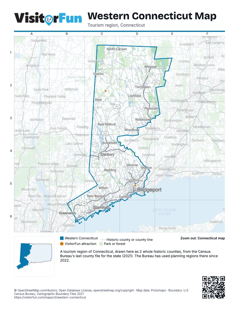
Highway index of Western Connecticut
Each highway on the sheet and the grid squares it crosses.
- I-84C4, D4
- I-95B6, C5, C6, D5
- I-684B6
- US 6C4, D3, D4, E3
- US 7C1, C3, C4, C5, C6
- US 44C1, D1, E1, E2
- US 202C3, C4, D2, D3, E2
- CT 4D2
- CT 8D1, D2, D3, D5
- CT 15B6, C5, C6, D5
- CT 25C4, D4, D5
- CT 33C5
- CT 41C1
- CT 67C3
- CT 72E3
- CT 106C5
- CT 183D1
- CT 222D3
- CT 272D1
Things to do on the Western Connecticut map
- Aldrich Contemporary Art Museum
- American Museum of Tort Law
- Black Rock State Park
- Bruce Museum
- Burr Pond State Park
- Collis P. Huntington State Park
- Connecticut Audubon Society Birdcraft Museum and Sanctuary
- Connecticut's Beardsley Zoo
- Danbury Fair
- Danbury Museum and Historical Society
- Dennis Hill State Park
- Earthplace
- Fairfield Museum and History Center
- Housatonic Meadows State Park
- Indian Well State Park
- John A. Minetto State Park
- Kent Falls State Park
- Lake Waramaug State Park
- Lockwood-Mathews Mansion
- Lovers Leap State Park
- Macedonia Brook State Park
- Mount Tom State Park
- Peoples Forest Museum
- Putnam Memorial State Park
- Seth Low Pierrepont State Park Reserve
- Sherwood Island State Park
- SHU Discovery Science Center & Planetarium
- Squantz Pond State Park
- Stamford Museum & Nature Center
- Stamford Town Center
- The Glass House
- Topsmead State Forest
- Waveny Park
- Weir Farm National Historical Park
Places on the map
- Bridgeport
- Brookfield
- Danbury
- Fairfield
- Greenwich
- Kent
- Litchfield
- Monroe
- New Canaan
- New Milford
- North Canaan
- Plymouth
- Redding
- Sharon
- Shelton
- Stamford
- Torrington
- Trumbull
- Watertown
- Wilton
- Winsted
- Woodbury
Next to Western Connecticut
- Central Connecticut map
- Western Massachusetts
- Hudson Valley
© OpenStreetMap contributors, Open Database License, openstreetmap.org/copyright · Map data: Protomaps · Boundary: U.S. Census Bureau, Cartographic Boundary Files 2021