

Georgia map
Atlanta-Sandy Springs-Roswell Metro Area map
The sheet's index lists 48 highways; US 19, GA 3 and I-20 cross the most grid squares. Things to do inside the boundary: Amicalola Falls State Park, Archibald Smith Plantation Home and ATL-Cruzers Electric Car & Segway Tours. Also on it: Adairsville, Alpharetta and Atlanta.
Open the map (PDF, US Letter)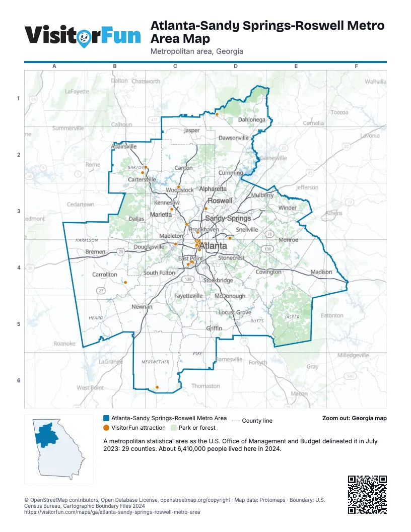
Highway index of Atlanta-Sandy Springs-Roswell Metro Area
Each highway on the sheet and the grid squares it crosses.
- I-20A4, B4, C4, D4, E4, F4
- I-75B2, C2, C3, C4, D4, D5
- I-85B5, C3, C4, C5, D3, E3
- I-285C3, C4, D3, D4
- I-575C2, C3
- I-675D4
- I-985D3
- US 19C3, C4, C5, C6, D1, D2, D3, D4, D5, D6
- US 23C4, D3, D4
- US 27A3, B3, B4, B5
- US 29C4, D3, D4, E3
- US 41B2, C3, C4, D4, D5
- US 78C4, D3, D4, E3
- US 129D1, E4, F4
- US 278B3, C3, C4, D4
- US 411B2, C2
- US 441E4, F4
- GA 1A3, B3, B4, B5
- GA 3B2, C3, C4, C5, C6, D4, D5, D6
- GA 5C1, C2, C3
- GA 6B3, C3, C4
- GA 8C4, D3, D4, E3
- GA 9C3, C4, D1, D3
- GA 10C4, D3, D4, E3
- GA 11D1
- GA 12D4
- GA 13C3, C4
- GA 14C4
- GA 16B4
- GA 20B2, C2, D2, D3, D4, D5
- GA 24E4, F4
- GA 42C4, D4
- GA 53C2
- GA 54C4
- GA 60D1, D2
- GA 61B2, C2
- GA 100B5
- GA 120B3, C3, D3
- GA 124D3, D4
- GA 138C4, D4, E3, E4
- GA 141C3, D2, D3
- GA 154C4
- GA 166B4, C4
- GA 316D3, E3
- GA 360B3, C3
- GA 400C3, D2, D3
- GA 410D3
- GA 515C1, C2
Things to do on the Atlanta-Sandy Springs-Roswell Metro Area map
- Amicalola Falls State Park
- Archibald Smith Plantation Home
- ATL-Cruzers Electric Car & Segway Tours
- Atlanta BeltLine Eastside Trail
- Atlanta Botanical Garden
- Atlanta History Center
- Austell Museum
- Bartow History Museum
- Booth Western Art Museum
- Centennial Olympic Park
- Center for Puppetry Arts
- Chastain Memorial Park
- Chattahoochee River National Recreation Area
- Children's Museum of Atlanta
- College Football Hall of Fame
- Commemorative Air Force Airbase Georgia Warbird Museum
- Dahlonega Gold Museum State Historic Site
- Delta Flight Museum
- Embassy Suites by Hilton Atlanta Midtown
- Etowah Indian Mounds State Historic Site
- Euharlee Welcome Center & History Museum
- Fernbank Museum of Natural History
- Fox Theatre
- Freeman's Mill Park
- Georgia Aquarium
- Gone with the Wind Museum
- Heritage Hall
- High Museum of Art
- Hiram Rosenwald School Museum
- Historic Banning Mills
- Historic Fourth Ward Park
- Indian Springs State Park
- Jimmy Carter Presidential Library & Museum
- Kennesaw Mountain National Battlefield Park
- Krog Street Market
- LEGO Discovery Center Atlanta
- Lenox Square
- Mall of Georgia
- Marietta Confederate Cemetery
- Marietta Fire Museum
- Marietta National Cemetery
- Marietta/Cobb Museum of Art
- Martin Luther King, Jr. National Historical Park
- Mercedes-Benz Stadium
- Michael C. Carlos Museum
- Millennium Gate Museum
- Mimms Museum of Technology and Art
- Monroe Museum
- Museum of Contemporary Art of Georgia
- Museum of History and Holocaust Education
- National Center for Civil and Human Rights
- Noble Hill-Wheeler Memorial Center
- Panola Mountain State Park
- Perimeter Mall
- Phipps Plaza
- Pickett's Mill Battlefield State Historic Site
- Piedmont Park
- Ponce City Market
- Renaissance Atlanta Airport Gateway Hotel
- Rhodes Hall
- Road To Tara Museum
- Robert C. Williams Paper Museum
- Roosevelt's Little White House
- Rose Lawn Museum
- Savoy Automobile Museum
- Screaming Eagle Ziplines
- Six Flags Over Georgia
- SkyView Atlanta
- Smith-Gilbert Gardens
- Sonesta Atlanta Airport North
- Southlake Mall
- State Farm Arena
- Stone Mountain Park
- Sweetwater Creek State Park
- Tellus Science Museum
- The Outlet Shoppes at Atlanta
- The Varsity
- Truist Park
- West Georgia Museum
- William Root House Museum & Garden
- World of Coca-Cola
- Zoo Atlanta
Places on the map
- Adairsville
- Alpharetta
- Atlanta
- Bremen
- Brookhaven
- Canton
- Carrollton
- Cartersville
- Covington
- Cumming
- Dahlonega
- Dallas
- Dawsonville
- Douglasville
- East Point
- Fayetteville
- Griffin
- Jasper
- Kennesaw
- Locust Grove
- Mableton
- Madison
- Marietta
- McDonough
- Monroe
- Mulberry
- Newnan
- Roswell
- Sandy Springs
- Snellville
- South Fulton
- Stockbridge
- Stonecrest
- Winder
- Woodstock
© OpenStreetMap contributors, Open Database License, openstreetmap.org/copyright · Map data: Protomaps · Boundary: U.S. Census Bureau, Cartographic Boundary Files 2024