

District of Columbia map
Washington-Arlington-Alexandria Metro Area map
The sheet's index lists 48 highways; US 15, I-66 and US 17 cross the most grid squares. Things to do inside the boundary: 9:30 Club, Abraham Hall Historic Site and Acorn Park. Also on it: Alexandria, Arlington and Ballenger Creek.
Open the map (PDF, US Letter)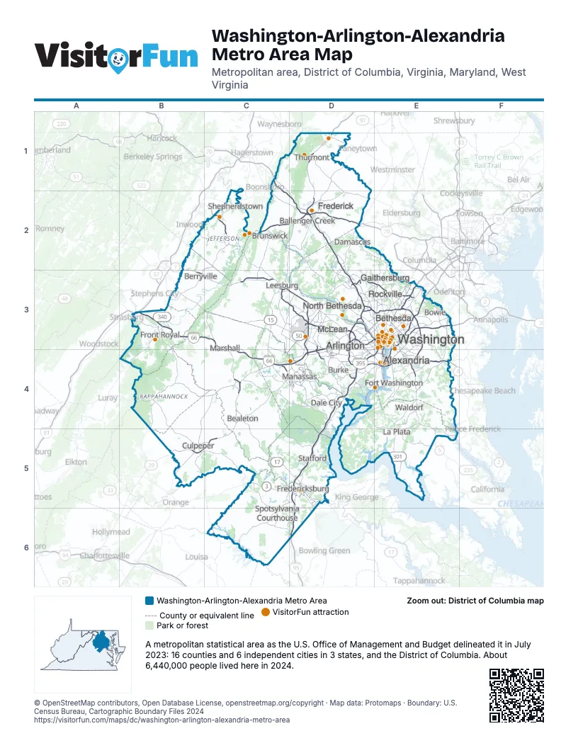
Highway index of Washington-Arlington-Alexandria Metro Area
Each highway on the sheet and the grid squares it crosses.
- I-66B3, C3, C4, D3, D4, E3
- I-70C1, C2, D2
- I-81B3
- I-95D4, D5, D6, E3, E4
- I-270D2, D3
- I-295E3, E4
- I-370D3
- I-395D4, E3, E4
- I-495D3, D4, E3, E4
- I-695E3
- US 1D4, D5, E3, E4
- US 15B5, C2, C3, C4, C5, D1, D2
- US 17B3, C3, C4, C5, D5, D6
- US 29B5, C4, C5, E3
- US 40D2
- US 50B3, C3, D3, E3
- US 211B4, C4
- US 301E3, E4, E5
- US 340B2, B3, C2, D2
- US 522B3, B4, B5
- MD 3E3
- VA 3B5, C5, D5
- MD 4E3, E4
- MD 5E4, E5
- VA 7B2, B3, C3, D3
- VA 9C2, C3
- WV 9C2
- VA 20C5
- MD 27D2
- VA 27E3
- VA 28C4, D3, D4
- WV 51C2
- VA 55C3, C4
- VA 110E3
- VA 123D4
- MD 140D1
- MD 200D3, E3
- MD 201E3
- MD 210E4
- MD 228E4
- VA 234C4, D4
- VA 267C3, D3
- VA 286D3, D4
- VA 294D4
- DC 295E3
- MD 337E4
- MD 450E3
- SR 638D4
Things to do on the Washington-Arlington-Alexandria Metro Area map
- 9:30 Club
- Adams Morgan
- Admiral David G. Farragut Memorial
- African American Civil War Memorial
- American University Museum
- Anacostia Community Museum
- Arena Stage
- Art Museum of the Americas
- Basilica of the National Shrine of the Immaculate Conception
- Battery Kemble Park
- Belmont–Paul Women's Equality National Monument
- Ben's Chili Bowl
- Butt–Millet Memorial Fountain
- Capital One Arena
- Capitol Hill Hotel
- Congressional Cemetery
- Constitution Gardens
- Crispus Attucks Park
- DAR Museum
- DC USA
- District of Columbia War Memorial
- Dumbarton Oaks
- Dupont Circle
- Dwight D. Eisenhower Memorial
- East Potomac Park
- Eastern Market
- Emancipation Memorial
- Embassy Row
- Enid A. Haupt Garden
- Farragut Square
- First Division Monument
- Folger Shakespeare Library
- Ford's Theatre
- Fort Reno Park
- Fort Stevens
- Franklin Delano Roosevelt Memorial
- Franklin Square
- Frederick Douglass National Historic Site
- George Mason Memorial
- George Washington Memorial Parkway
- Glover Archbold Park
- Henry Wadsworth Longfellow Memorial
- Hillwood Estate, Museum & Gardens
- Hilton Garden Inn Washington DC/U.S. Capitol
- Hirshhorn Museum and Sculpture Garden
- Holodomor Memorial
- House of the Temple
- Interior Museum
- International Spy Museum
- James A. Garfield Monument
- Japanese American Memorial to Patriotism During World War II
- John Ericsson National Memorial
- Kahlil Gibran Memorial Garden
- Kenilworth Park and Aquatic Gardens
- Key Bridge Boathouse
- Korean War Veterans Memorial
- Kreeger Museum
- Lady Bird Johnson Park
- Lafayette Square
- Library of Congress, Thomas Jefferson Building
- Lillian & Albert Small Capital Jewish Museum
- Lincoln Memorial
- Lincoln Park
- Lyndon Baines Johnson Memorial Grove on the Potomac
- Martin Luther King, Jr. Memorial
- Mary McLeod Bethune Council House National Historic Site
- McPherson Square
- Meridian Hill Park
- Museum of the Bible
- National Archives Museum
- National Building Museum
- National Cherry Blossom Festival
- National Children's Museum
- National Gallery of Art
- National Law Enforcement Officers Memorial
- National Mall
- National Museum of African American History and Culture
- National Museum of African Art
- National Museum of American Jewish Military History
- National Museum of Asian Art
- National Museum of the American Indian
- National Museum of Women in the Arts
- National Portrait Gallery
- National Postal Museum
- Old Town Trolley Tours of Washington DC
- Peace Monument
- Pennsylvania Avenue National Historic Site
- Renwick Gallery
- Rock Creek Park
- Saint John Paul II National Shrine
- Smithsonian American Art Museum
- Smithsonian National Air and Space Museum
- Smithsonian National Museum of American History
- Smithsonian National Museum of Natural History
- Smithsonian's National Zoo
- Supreme Court of the United States
- The Phillips Collection
- The Textile Museum
- The Westin Washington, D.C. City Center
- The White House
- Theodore Roosevelt Island
- Thomas Jefferson Memorial
- Tidal Basin
- Tudor Place
- U.S. Capitol & Capitol Visitor Center
- Ulysses S. Grant Memorial
- Union Market
- Union Station
- United States Botanic Garden
- United States Holocaust Memorial Museum
- United States National Arboretum
- United States Navy Memorial
- Victims of Communism Memorial
- Vietnam Veterans Memorial
- Washington Monument
- Women's Titanic Memorial
- World War II Memorial
- Zero Milestone
Places on the map
- Alexandria
- Arlington
- Ballenger Creek
- Bealeton
- Berryville
- Bethesda
- Bowie
- Brunswick
- Burke
- Culpeper
- Dale City
- Damascus
- Fort Washington
- Frederick
- Fredericksburg
- Front Royal
- Gaithersburg
- La Plata
- Leesburg
- Manassas
- Marshall
- McLean
- North Bethesda
- Rockville
- Shepherdstown
- Spotsylvania Courthouse
- Stafford
- Thurmont
- Waldorf
- Washington
© OpenStreetMap contributors, Open Database License, openstreetmap.org/copyright · Map data: Protomaps · Boundary: U.S. Census Bureau, Cartographic Boundary Files 2024